
Nestos (river)
This articleneeds additional citations forverification.(December 2009) |
| Nestos (Νέστος), Mesta (Места) | |
|---|---|
 | |
| Location | |
| Countries | BulgariaandGreece |
| Physical characteristics | |
| Source | |
| • location | Rila Mountains,Bulgaria |
| • coordinates | 42°07′10″N23°35′10″E/ 42.11944°N 23.58611°E |
| • elevation | 2,240 m (7,350 ft) |
| Mouth | |
• location | Aegean SeaoppositeThasos,Greece |
• coordinates | 40°50′51″N24°48′15″E/ 40.84750°N 24.80417°E |
| Length | 230 km (140 mi) |
| Basin size | 5,184 km2(2,002 sq mi) |
| Discharge | |
| • location | Hadzhidimovo,Bulgaria |
| • average | 29.85 m3/s (1,054 cu ft/s) |
TheNestos(Greek:Νέστος[ˈnestos]),Mesta(Bulgarian:Места[ˈmɛstɐ]) is a river inBulgariaandGreece.It rises in theRila Mountainsand flows into theAegean Seanear the island ofThasos.It plunges down towering canyons toward the Aegean Sea through mostly metamorphic formations. At the end, the main stream spreads over the coastal plain ofChrysoupolisand expands as adeltaicsystem withfreshwaterlakes and ponds forming the Nestos delta. The length of theriveris 230 km (140 mi), of which 126 km (78 mi) flow throughBulgaria[1]and the rest inGreece.Its drainage area is 5,184 km2(2,002 sq mi), of which 66% is in Bulgaria.[2]It forms some gorges inRilaandPirin.The longest gorge between Pirin to the west and theRhodope Mountainsto the east is the 25-km longMomina Klisurain Bulgaria.
The Mesta's longest tributary is theDospat(or Despatis). The banks of the river are covered mainly by deciduous trees that extend into halfway between Bulgaria and Greece where it forms the modern boundary ofGreek MacedoniaandThrace,as well as the boundary between theKavalaand theXanthiregional units, having first crossed theDrama regional unit.The river later forms a delta to the north where swamplands, wetlands and a lagoon once existed except in the east.
History[edit]
In theGeographyof ClaudiusPtolemy,the river is referred to as Nestus (Νέστος), and is said to form the boundary between ancient Macedonia and Thrace.[3]
Because of its flow betweencanyonsand inaccessiblemountainareas, Nestos was not navigable in antiquity and also did not offer a natural terrestrial road along theriverbed.Concerning the horizontal communication from the East to the West, the river had only two passes, one in the middle and the other in the lower watercourse, which were controlled respectively by the cities ofNicopolisand Topeiros. The first pass, near Nicopolis, allowed the communication between the valleys of the riversStrymonandHebros(Evros), while through the second pass, near Topeiros, passed an ancient road (and later theRoman roadofVia Egnatia) that served the communication between the East and the West. In Nestos' valley (east bank) north of the south pass, theDiiused to live, whileSatraewere living to the south. Finally, Nestos played an important role in theurbanand economic history of the inhabitants of theestuary,where the city ofAbderaand laterTopeiros,founded by the EmperorTrajan.This is presumed by the deification of the river and its depiction oncoinsof the imperial period.[4]
Honour[edit]
Mesta PeakonLivingston Islandin theSouth Shetland Islands,Antarcticais named afterMestaRiver.
Gallery[edit]
-
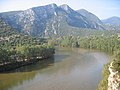 Nestos in Greece
 -
 TheMomina Klisuragorge along the Mesta in Bulgaria


References[edit]
- ^Statistical Yearbook 2017,National Statistical Institute (Bulgaria),p. 17
- ^"Preliminary Flood Risk Assessment"(in Greek). Ministry of Environment, Energy and Climate Change. p. 90. Archived fromthe originalon 15 February 2020.
- ^Geography of Claudius Ptolemy, Book 3, Chapter 11
- ^D. C. Samsaris, Historical Geography of Western Thrace during the Roman Antiquity (in Greek),Thessaloniki2005, p. 33-36
- Rivers of Bulgaria
- Rivers of Greece
- Nestos basin
- Geography of Thrace
- International rivers of Europe
- Landforms of Blagoevgrad Province
- Landforms of Smolyan Province
- Landforms of Pazardzhik Province
- Rivers of Eastern Macedonia and Thrace
- Landforms of Kavala (regional unit)
- Landforms of Xanthi (regional unit)
- Landforms of Drama (regional unit)