
Neukloster
Neukloster | |
|---|---|
 Town hall | |
 Coat of arms | |
Location of Neukloster within Nordwestmecklenburg district  | |
 Neukloster  Neukloster | |
| Coordinates:53°52′N11°41′E/ 53.867°N 11.683°E | |
| Country | Germany |
| State | Mecklenburg-Vorpommern |
| District | Nordwestmecklenburg |
| Municipal assoc. | Neukloster-Warin |
| Government | |
| •Mayor | Frank Meier |
| Area | |
| • Total | 27.49 km2(10.61 sq mi) |
| Elevation | 30 m (100 ft) |
| Population (2022-12-31)[1] | |
| • Total | 4,014 |
| • Density | 150/km2(380/sq mi) |
| Time zone | UTC+01:00(CET) |
| • Summer (DST) | UTC+02:00(CEST) |
| Postal codes | 23992 |
| Dialling codes | 038422 |
| Vehicle registration | NWM |
| Website | neukloster.de |
Neuklosteris a town in the east of the district ofNordwestmecklenburg,Mecklenburg-Western Pomerania,Germany.This town is the administrative center of the bureau Neukloster-Warin, which includes eight more communes.
Neukloster is close to the cities ofLübeck,WismarandSchwerinand is part of theHamburg Metropolitan Region.
Geography
[edit]Neukloster is located at the Neuklostersee (Lake Neukloster), which originates from the Ice Age. The area around Neukloster belongs to the outmost north-western part of theSternberger Seenlandschaft(Seascape of Sternberg). Neukloster is approx. 45 km (28 mi) away fromRostockand approx. 20 km (12 mi) away fromWismar.
The villagesLübberstorf,Glasin,Zurow,BenzandZüsowborder on Neukloster.
History
[edit]The history of Neukloster goes back to the Middle Ages, like most of the other places around. In 1170 the Kussinger Burg (Kussinger Castle) already existed in today's city limits of Neukloster. It is supposed that the center of the castle was located in the center of today's city center.
In the Middle Ages the Kloster Sonnenkamp (Sonnenkamp Convent) was located in the smaller village of Parchow. During this period, that area was hard-fought and it was exposed to the violence of the Middle Ages. The convent was relocated to Neukloster. This convent in Neukloster was first mentioned in 1219. The castle tumbled down with time, nevertheless the convent developed into a cultural and commercial center for this region. The convent was closed in the year of 1555. Its wealth and real estate went to the property of the Lords ofMecklenburg.
AfterThirty Years' War,in 1648, Neukloster,Wismarand some closer places, fell under the lordship of Sweden. During this period of time, Neukloster was confronted with impecuniousness and balefulness, but after all, Neukloster endured this time until 1803. In that year, the Swedish occupation decided to lease Neukloster (and all other areas in Mecklenburg) toMecklenburg-Schwerinfor 100 years. After these 100 years, Neukloster and all other leased areas around, were annexed toMecklenburg.
Neukloster became more important for the region, when the "Lehrerseminar" (seminar for teachers) moved fromLudwigslustto that small town, in 1862. Two years later, the "Landesblindenanstalt" (state's home for the blind) was founded in Neukloster. The population increased quickly, trade and industry were booming. In 1887, Neukloster was linked to the local railroad network.
In 1938, Neukloster received its town charter; the population doubled in the years afterWorld War II,from 2,500 to almost 5,000 inhabitants. During theGerman Democratic Republic,1949–1990, the landscape of Neukloster changed dramatically. Neukloster got a small town appearance. Many buildings were built, i.e. a campground, a movie theater, an old people's home, a stadium, schools, a kindergarten, the building of the Catholic Church and the market place.
Within the "Städebauförderung" (urban development sponsorship), Neukloster has been renovated since 1991.
Transport connection
[edit]Neukloster is connected with theBundesautobahn 20(interstate #20). The Bundesstraße 192 (highway #192) (Wismar–Neubrandenburg) is only 3 km (1.9 mi) away from Neukloster. The railroad station is closed. To go farer distances, it is recommended to take the railroad station inBad KleinenorRostock.
-
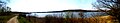 Lake Neukloster
References
[edit]
| International | |
|---|---|
| National | |