Nilópolis
22°48′28″S43°24′50″W/ 22.80778°S 43.41389°W
Nilópolis | |
|---|---|
| Município de Nilópolis | |
 A view of the city | |
| Motto: "Terra da Azul e Branca" | |
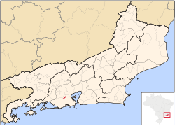
 Location of Nilópolis in theState of Rio de Janeiro | |
| Coordinates:22°48′19″S43°24′55.91″W/ 22.80528°S 43.4155306°W | |
| Country | |
| Region | Southeast |
| State | |
| Founded | August 21, 1947 |
| Government | |
| •Mayor | Abraãozinho David Neto (PL) |
| Area | |
| • Total | 19.157 km2(7.397 sq mi) |
| [1] | |
| Elevation | 14 m (46 ft) |
| Population (2020[2]) | |
| • Total | 162,693 |
| • Density | 8,500/km2(22,000/sq mi) |
| Time zone | UTC-3 |
| Postal Code | 28000-000 |
| Area code | +55 21 |
| Website | nilopolis.rj.gov.br |


Nilópolis(Portuguese pronunciation:[niˈlɔpoliʃ],[niˈlɔpɔliʃ],[niˈlɔpuliʃ]) is amunicipalityinBrazil,located in theRio de Janeiro state's southwestern region, borderingSão João de Meriti,MesquitaandRio de Janeiro.It is the smallest municipality in Rio de Janeiro state, with a total area of 19.39 km2.The population of 162,693 inhabitants living in an area of 9 km2and the remaining area corresponds to the Gericinó's Natural Park. Officially, the population density exceeds 8,120 inhabitants/km2,but if calculated just 9 km2occupied, it becomes the most densely populated city in Brazil with more than 17.400 inhabitants/km2.Currently,São João de Meritihas the highest population density, with 12,897 inhabitants/km2.
The city was named afterNilo Peçanha,aPresident of Brazil.
Beija Flor
[edit]Nilópolis is famous for itsGrêmio Recreativo Escola de Samba Beija-Flor de Nilópolis,one of the most successful and luxuriousSamba schoolsand usually a top contender for winning the carnival parade in Rio.[citation needed]
References
[edit]External links
[edit]- (in Portuguese)Prefeitura de Nilópolis (Nilópolis City Hall)
- (in Portuguese)Baixada Fácil (Nilópolis history)


