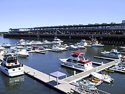
Old Port of Montreal
| Old Port of Montreal Vieux-Port de Montréal(French) | |
|---|---|
 The Old Port of Montreal | |
 Click on the map for a fullscreen view | |
| Location | |
| Country | Canada |
| Location | Montreal,Quebec |
| Details | |
| Opened | 1830 |
| Operated by | Old Port of Montreal Corporation,Canada Lands Company |
| Statistics | |
| Website http:// oldportofmontreal / | |
TheOld Port of Montreal(French:Vieux-Port de Montréal) is the historicportofMontreal,Quebec,Canada.Located adjacent toOld Montreal,it stretches for over 2 km (1.2 mi) along theSaint Lawrence River.It was used as early as 1611, when Frenchfur tradersused it as atrading post.
In 1976, Montreal's Port activities were moved east to the presentPort of Montrealin the borough ofMercier–Hochelaga-Maisonneuve.[1]
The Old Port was redeveloped in the early 1990s, under the direction of architectsAurèle CardinalandPeter Rose.[2]It is today a recreational and historical area and draws six milliontouristsannually.[1]
Attractions[edit]
The historical Old Port offers Montrealers and visitors alike access to a wide variety of activities, including theMontréal Science Centre,with anIMAXTheatre, and theMontreal Clock Tower.It offers riverfront access for walking, cycling, roller-blading, quadricycle, pedalo andSegwayrentals. It is also located at the eastern end of theLachine Canal,which has itself been extensively refurbished as a popular destination for cycling, roller-blading and pleasure boating. Cultural events include theFestival Montréal en lumière,Igloofestand theMatsuri Japonfestival.
In June 2012, anurban beach,called thePlage de l'Horloge(Clock Tower Beach), opened adjacent to theClock Tower.[3][4]
The Old Port of Montreal changed its name to The Quays of the Old Port of Montreal in 2005. Approximately every two years theCirque du Soleillaunches a new show from the Jacques Cartier Quay.[5]
The Old Port was rejected as the site of a proposedaerial gondola.[6][7]
The Old Port was also known as one of the most famous fishing spots in the greater Montreal area. A popular shore fishing position isParc de la Cité-du-Havre,which provides a fishing spot with a wide range of fish species. In the winter, ice fishing events were held on the ice inside the old port.
TheGrande roue de MontréalFerris Wheel opened in 2017 at the Old Port. It is the tallest ferris wheel in Canada.[8]
Management[edit]
The Old Port is managed by the Old Port of Montreal Corporation, a subsidiary ofCanada Lands Company.The Old Port of Montreal reports directly to Canada Lands Company.[9]
See also[edit]
References[edit]
- ^ab"History of the Old Port".Old Port of Montreal Corporation inc.Retrieved18 September2012.[permanent dead link]
- ^Affleck, Gavin."IN FULL VIEW: PUBLIC SPACE IN MONTREAL".Canadian Architect..
- ^{aMKOAKZM3EJ3DNF RJL3K4M2E1,.DEFMRReid, Evelyn (June 12, 2012)."The Old Port's Clock Tower Beach: Montreal's Other Urban Beach".About.Archived fromthe originalon May 30, 2015.RetrievedMay 29,2015.
- ^Riga, Andy (March 2, 2012)."Montreal's Old Port beach: sand, boardwalk, umbrellas – but no swimming and it won't be free".Montreal Gazette.Archived fromthe originalon March 5, 2012.RetrievedMarch 2,2012.
- ^Fodor's (2013-02-26).Fodor's Montreal & Quebec City 2013.Travel Distribution.ISBN9780891419402.
- ^Brownstein, Bill (31 December 2008)."One family's dream would be our trippy view of the city, river and mountain".Canada.Retrieved9 September2015.[permanent dead link]
- ^Burnett, Richard(11 December 2008)."Montreal Aerial Gondola: Up in the air".Hour.Archived fromthe originalon 4 March 2016.Retrieved9 September2015.
- ^Castilloux, Charlotte."La Grande roue du Vieux-Port enfin ouverte".Le Journal de Montréal(in French).
- ^"Canada Lands to oversee Old Port of Montreal after expense scandal".
