
Ovalau
This articleneeds additional citations forverification.(September 2014) |
 Ovalau and nearby islands in the 19th century, with the coast ofViti Levuin the west. | |
 Ovalau Location in Fiji | |
| Geography | |
|---|---|
| Location | Fiji |
| Coordinates | 17°41′17″S178°47′26″E/ 17.68806°S 178.79056°E |
| Archipelago | Lomaiviti |
| Adjacent to | Koro Sea |
| Total islands | 1 |
| Major islands | 1 |
| Area | 106.4 km2(41.1 sq mi)[1] |
| Area rank | 6th |
| Length | 13.7 km (8.51 mi) |
| Highest elevation | 626 m (2054 ft)[2] |
| Administration | |
Fiji | |
| Division | Eastern |
| Province | Lomaiviti Province |
| District | Ovalau |
| Largest settlement | Levuka(pop. 2500) |
| President | George Konrote |
| Demographics | |
| Demonym | Fi gian s |
| Population | 9100 (2014) |
| Pop. density | 85.526/km2(221.511/sq mi) |
| Ethnic groups | Native Fi gian s,Indo-Fi gian s;other (Asian,Europeans,otherPacific Islander) |
Ovalau(pronounced[oβaˈlau]) is the sixth largest island inFiji.It is located inLomaiviti Archipelago.Situated at 17.70° South and 178.8° East, (60 km north east from the national capitalSuvaand 20 km off the east coast ofViti Levu), the island is about 13 kilometers long and 10 kilometers wide. It covers a total area of 106.4 square kilometers and has a population of around 9,100, approximately half of the population of Lomaiviti Province over the 1956–2007 period.[3]Levuka,Fiji's formercapital,is the largest of 24 towns and villages on the island, and is the only urban area in Lomaiviti.[3]All settlements are coastal, except Lovoni in the interior of the island.[4]
Ovalau is characterized by its ruggedtopography,[2]with little flat land apart from theLovoni Valleyin the centre of the island. The island is an eroded volcanic crater with a narrow belt of flat to undulating country between the encircling lagoon and the steep crater sides. The highest peaks areNadelaiovalau,with an elevation of 625 meters, in the east, andTomuna,526 meters, in the south.Moturikiis just off the southwest coast of Ovalau. To the north-west isNaigani,and to the east isWakaya.
Transport around Ovalau
[edit]There is one road which circles the island. However, between the villages of Rukuruku and Buresala the road is little more than a track, as travel between these points is uncommon, most traffic being directed from these two villages toLevuka.Levuka Airfield,which handles twice-dailyAir Fijiflights to and fromSuvais located on the west of the island, next to the Bureta District School compound. There is one flight in the morning, and one in the evening, with only the evening service operating on Sundays. Flights cost around FJ$150 return.
Ferry services also connect Ovalau toViti Levu- thePatterson Brothers Shipping Company LTDferry company runs a service between Levuka, Buresala,Natovi,andSuvadepending on the day.
Transport around the island is mainly by carrier. There is one bus service, which runs once daily from the west of Ovalau to Levuka in the morning, and returns at 5pm, and is mainly used by schoolchildren andPAFCOworkers.
-
 Sacred Heart Church,Levuka,Ovalau
 -
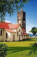
 St John's Church, Ovalau
 -
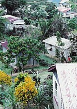 LovoniVillage, Ovalau
 -
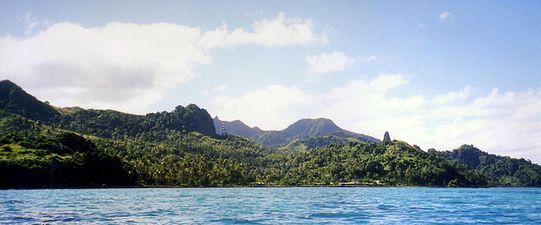 The south western side of Ovalau


In popular culture
[edit]A fictionalized Ovalau appears in the 2013tactical shootervideo gameArma 3,specifically in theArma 3: Apexdownloadable contentexpansion pack,as the archipelago of "Tanoa", part of theisland countryof the "Horizon Islands Republic". In the game, the island itself is oriented sideways and includes avolcano,Moturiki is split into multiple islands, thebarrier islandsoff the southeast coast are larger and now off the east coast, and additional islands have been added off the western and southern coasts.
References
[edit]- ^Gillespie, Rosemary G.; D. A. Clague (2009).Encyclopedia of Islands.University of California Press. p. 299.ISBN0520256492.
- ^abPub. 126 Sailing Directions (Enroute) Pacific Islands(12 ed.). Springfield, Virginia:National Geospatial-Intelligence Agency.2017. p. 88.Retrieved24 July2023.
- ^ab"Lomaiviti - A Profile of the Demographic and Socio-economic Characteristics of the Population of the Province Based on 1996 and 2007 Census Data".Fiji Bureau of Statistics.2013.Retrieved24 July2023.
- ^Ramoli, A.; Nunn, Patrick D. (2001)."Naigani Island and its historical connections with Ovalau and Moturiki Islands: convergences between legend and fact"(PDF).Domodomo (Scholarly Journal of the Fiji Museum).13:19–28.ISSN0257-1668.Retrieved26 July2023.
External links
[edit] Ovalautravel guide from Wikivoyage
- Levuka Fiji