
Padiham
| Padiham | |
|---|---|
 | |
 Padiham Shown within Burnley Borough  Padiham Location withinLancashire | |
| Area | 2.46 sq mi (6.4 km2)[1] |
| Population | 10,098(2011)[1] |
| •Density | 4,105/sq mi (1,585/km2) |
| OS grid reference | SD7933 |
| Civil parish |
|
| District | |
| Shire county | |
| Region | |
| Country | England |
| Sovereign state | United Kingdom |
| Post town | BURNLEY |
| Postcode district | BB12 |
| Dialling code | 01282 |
| Police | Lancashire |
| Fire | Lancashire |
| Ambulance | North West |
| UK Parliament | |


Padiham(/ˈpædiəm/PAD-i-əm) is a market town andcivil parishon theRiver Calder,in theBorough of BurnleyinLancashire,England. It is located north west ofBurnley,and north east of the towns ofClayton le MoorsandGreat Harwood.It is edged by the foothills ofPendle Hillto the north-west and north-east. TheUnited Kingdom Census 2011gave a parish population of 10,098,[1]estimated in 2019 at 10,138.[2]
History
[edit]Early forms of the name include "Padingham", with the last element probably from theOld Englishwordhām,meaning home andingin this sense meaning "of the". Its first is generally thought to be a personal name (Bedelisted Padda as one of the priests who assistedBishop Wilfridin the late 7th Century).[3][4]
No prehistoric orRomansites have been found in the built-up area. Padiham, though a name ofAnglo-Saxonorigin, is not recorded in the 1086Domesday Book.[5]Padiham was never a separatemanor,its lands largely being held bycopyholdtenants of the Manor of Ightenhill, a part of theHonour of Clitheroe.In 1258 there was a single free tenant, one Gilbert de Padiham. The Lord of Clitheroe had established a water-powered corn mill here by 1311.[6]It remained for centuries as a market town, where produce fromPendlesidewas bought and sold. The town expanded and was redeveloped during theIndustrial Revolution.The centre is now aconservation area.
Padiham's population peaked around 1921 at about 14,000, declining to 10,000 in the early 1960s and 8,998 at the time of the 2001 census.[7][8]This reflected how people were moving to the south of England in search of work, after the decline in the traditional cotton, coal and engineering manufacturing industries.
Queen Elizabeth IIandPrince Philipfirst visitedBurnley,Nelsonand the oldMullardvalve factory atSimonstonenear Padiham on their post-Coronationtour of Lancashire in 1955.[9]
Governance
[edit]Padiham, once atownshipin the parish of Whalley, became acivil parishin 1866.[7]Anurban districtcovered the town from 1894 until 1974, but over this time, some rural areas mainly to the north became a new civil parish, Northtown, as part ofBurnley Rural District.[10]The Padiham Green area, hitherto part of Hapton,[a]joined Padiham, with another small area following in 1935.[7]Since 1974 Padiham has formed part of theBorough of Burnley.Initially part of anunparished area,a new Padiham civil parish was formed in late 2001, covering a similar area to the old urban district.[12]ATown Councilwas instituted in 2002.[13]Further boundary changes in 2004 saw the parish gain more territory in the south from Hapton.[14]
Councillors for Padiham onBurnley Borough Councilare elected to theGawthorpe Ward,which covers most of Padiham, but notGawthorpe Hall,[15]with southern and eastern areas covered by Hapton with Park Ward.[16]The two wards each electthree councillors, John Harbour and Alun Lewis of theLabour Partyand Karen Ingham (Conservative) currently serving Gawthorpe and Joanne Broughton, Alan Hosker, and Jamie McGowan, all of theConservativesin Hapton with Park.[17]The parish is represented onLancashire County Councilas part of the Padiham & Burnley Westdivision,represented since2017by Alan Hosker.[18]The Parliamentary Constituency,Burnley,is currently represented byOliver Ryanfor the Labour Party.
Demography
[edit]According to theUnited Kingdom Census 2011,the parish had a population of 10,098,[1]an increase from 8,998 in the 2001 census.[19]The town forms part of a widerurban area,which had a population of 149,796 in 2001.[20]A similar but larger,Burnley Built-up areadefined in the 2011 census had a population of 149,422.[21]
The racial composition of the town in 2011 was 98.1% White (96.6% White British), 1.1% Asian, 0.1% Black, 0.5% Mixed and 0.1% Other. The largest religious groups were Christian (70.0%) and Muslim (0.6%). 68.3% of adults between the ages of 16 and 74 were classed as economically active and in work.[1]
| Year | 1901 | 1911 | 1921 | 1931 | 1939 | 1951 | 1961 | 2001 | 2011 | ||||||||||||
|---|---|---|---|---|---|---|---|---|---|---|---|---|---|---|---|---|---|---|---|---|---|
| Population | 12,205 | 13,635 | 12,471 | 11,633 | 10,011 | 10,041 | 9,899 | 8,998 | 10,098 | ||||||||||||
| UD(pre-1974)[22]CP(2001 onwards)[19][1] | |||||||||||||||||||||
Economy
[edit]In the 19th century, Padiham's industry was based oncoal-miningandweaving.Helm Mill on Factory Lane was the first mill built in 1807. By 1906 there were twentycotton mills[23]though the best preserved, now converted into flats, is Victoria Mill in Ightenhill Street, built in 1852–1853 and extended in 1873.[23]Many cotton workers belonged to thePadiham Weavers' Association,whose membership peaked in 1907 at over 6,000.[24][25]
Industrial development was helped by proximity to theLeeds and Liverpool Canal,about 2 miles (3.2 km) to the south. By 1848, Padiham had many coal pits around the town, including two large collieries and a number of smaller workings. Availability of coal and water nearby helped to boost the cotton industry.[5]Industry benefited further from the arrival of the railway atHaptonin 1840 and Padiham itself in 1877.[5]The last pit closed about 1870,[26]although mining continued in areas outside the town into the 1950s, andopen cast miningtook place in the 1960s east of the town close to Gawthorpe Hall, north of the River Calder off Grove Lane.
Since the 1960s, the remaining cotton mills have continued a decline that began in the 1930s. So too has Padiham's role as a manufacturing base since the 1990s. The town's last major employer in the sector,Baxi,closed its factory in March 2007, with a loss of 500 jobs.[27]A modern business park,Shuttleworth Mead,[28]opened in 2001 on the western edge of the town wherePadiham Power Stationhad stood until 1993.[29]The business park has been supported by £2.2 million from theEuropean Regional Development Fundand £2 million from theNorth West Development Agency.[30]Tenants include Supanet, an internet service provider (ISP) and Graham & Brown, a wall coverings company.
In 2007 Fort Vale Engineering developed a new purpose-built factory, where the oldMullard/Philips site at Calder Vale Park,Simonstonehad closed in 2004. Fort Vale Engineering employs some 280 local people and has brought business to other local employers.
Landmarks
[edit]There are five significant mansions in the local area:Huntroyde Hall,[31]dating from 1576, andSimonstone Hall,dating from 1660, in nearbySimonstone,are still privately owned.Gawthorpe Hallwas donated to theNational Trustin 1970, but is jointly managed withLancashire County Councilunder a 99-year lease. Gawthorpe is in theIghtenhilldistrict.[32] The National Trust also runs an office and a tearoom in the courtyard of the property.[33][34]Gawthorpe was owned by the Shuttleworth family, which heldShuttleworth Hallnear Hapton from the 12th century.[35][36]The current building dates from 1639 and is still a working farm.Read Hall and Parkis in the nearby village ofRead,about 1 mile (1.6 km) west of Padiham on theA671.

St Leonard's Parish Church dates from 1866 to 1869 and is aGrade II listed building.[37]It occupies the site of earlier churches dating back to 1451 or earlier.[38]The original churchyard was smaller in extent than today, being expanded to the northern edge in 1835.[5]
Padiham Town Hallin Burnley Road, built in 1938 to designs byBradshaw Gass & Hope,is a Grade II listed building.[39]
Padiham Memorial Park at the top of Church Street, was designed byThomas Mawson,a prolific landscape designer.[40][41][42]It was officially opened in 1921 as a memorial to those of the town who gave their lives in theFirst World War.It now commemorates victims of the Second World War as well.
The park covers 12 acres (4.9 ha) on two sites divided by the River Calder. The upper section is mainly formal, dominated by Knight Hill House, currently used as anAge UK(formerlyAge Concern) day centre, and has a rose garden, lawns and two memorials. The lower section, off Park Street, has two bowling greens, tennis courts, skate park and Padiham Leisure Centre. The park is aGreen Flag awardwinner.[43]The park still had remains of some Second World Warair raid sheltersin 2008.[44]

Another locally listed building is the former Padiham Building Society headquarters. A detached building over two storeys with large underground vault on Burnley Road, constructed between 1955-1958 and officially opened in 1959. The building was recently renovated by local businessman Liam Veitch and converted into individual office spaces.
Padiham War Memorial itself is at the main park entrance in Blackburn Road.[45]There is a second memorial at All Saints' with St John the Baptist off the A671, Padiham Road, opposite the George IV pub.[46]A local man, Thomas Clayton, funded the park in his will; public subscription provided additional money for the park's many features.[47]
Near the war memorial, the Air Crash Memorial recalls several local young people killed on 3 July 1970, when a Dan Airde Havilland Cometdeviated from its course and crashed into the high ground of theMontseny Rangein north-eastern Spain – see:Dan-Air Flight 1903.[48]The aircraft, destroyed on impact and by subsequent ground fire, contained three flight crew, four cabin crew and 105 passengers, all of whom died. It was the airline's first fatal accident involving fare-paying passengers.[49]The tour operator,Clarksons Holidays,was at the time Britain's largestpackage holidaycompany.[50]
Several other buildings in the area are also of historic interest. Hargrove can be seen from a public footpath off the Padiham by-pass just north of the town and the 1950s council housing estate north of Windermere Road. For over 400 years it was the home of the Webster family ofyeomanfarmers.[51]The house is probably 17th century and part of the Huntroyed estate. Coal from a localoutcropheated the house for many years. Stockbridge House in Victoria Road was occupied by the Holts, a farming family, in 1802 and has aJacobeanchimney.[51]High Whitaker Farm is north-east of Hargrove, accessible by public footpath from Higham Road and from Grove Lane. The building is 16th century and said to have been used tohide Catholicsduring the reign ofHenry VIII.[51]Other houses of note are Priddy Bank Farm and Foulds House Farm, both off Sabden Road, andArbory Lodgeon Arbory Drive.[51]
Media
[edit]Local news and television programmes are provided byBBC North WestandITV Granada.Television signals are received from theWinter HillTV transmitter and the local relay TV transmitter located in theForest of Pendle.[52][53]
Local radio stations areBBC Radio Lancashire,Heart North West,Smooth North West,Central Radio North West,Greatest Hits Radio LancashireandCapital Manchester and Lancashire(formerly2BR).[54]
The town is served by the local newspapers,Burnley ExpressandLancashire Telegraph.
Transport
[edit]Rail
[edit]Padiham railway stationwas on a branch line (known as theGreat Harwoodloop) of theEast Lancashire Linefrom Burnley toBlackburn.It opened in 1877, but was closed on 2 December 1957 and the station later demolished. The line was retained for deliveries of coal toPadiham Power Stationuntil that closed in 1993. The nearest railway station now is atHapton,about 2 miles (3.2 km) south. The old line was converted into a footpath/bridleway/cycleway calledPadiham Greenway,completed in June 2010.
Buses
[edit]The town is served byBurnley Bus Companyservices fromAccrington,Burnley,Nelson,Colneand beyond,[55]and by aBlackburn Bus Companyservice 152 fromBurnley,BlackburnandPreston.[56]
Road
[edit]Junctions 8 and 10 of theM65are both some 2 miles (3 km) from the town centre. Junction 8 of the M65 also gives access to theA56dual carriagewayleading to theM66and access to theManchestermotorway network.
Air
[edit]The nearest airport,Manchester,is 50 minutes' drive.[57]The best route by public transport is via Blackburn, then train. It takes some 2¼ hours.[58]
Historic maps
[edit]The 1845[5][59]map (1) shows the town of Padiham in the early days of the Lancashirecotton industryinVictorian times,with three mills marked. Most of the town at that stage was north of the river. The top left-hand corner shows part of theHuntroyde Demesne.[31]The River Calder, on the right of the map, flows to the north, having been diverted in the early 19th century from its original route, away from Gawthorpe Hall (shown in pink), because of pollution. In the 1960s the river was re-routed to its original course to accommodateopen-cast coal mining.[38]
The 1890Ordnance Surveymap (2) shows the cotton-industry growth of the cotton industry in the later 19th century. The 1–25,000 scale OS map (3) is a partial extract from the two maps indicated. Several historic locations shown includeRead Hall(A2) andRead(B2); Martholme, just east ofMartholme Viaduct(A3);Simonstoneand Simonstone Hall (C3);Huntroydand grounds (D1–D2);Padiham Power Station(D3) with the connecting line for fuel; post-war housing north of the town off Slade Lane (E2); High Whitaker (F1); the River Calder on the old course from Gawthore Hall and grounds (F2);Pendle Hall(G1);IghtenhillManor House (G2); and theLeeds and Liverpool Canalin Burnley (J1). The railway line through Padiham also appears.
-
 1: Map of Padiham c. 1844
 -
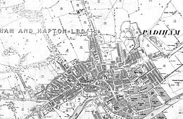 2: Ordnance Survey map dated 1890
 -
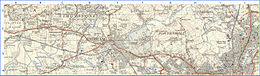 3: Extract from OS 1-25,000 scale maps SD73 (west section pub 1955) and SD83 (east section published 1954) showing historical locations around Padiham. Grid lines are 1 km.


Notable people
[edit]- Bill Blackadder(1899–1977), professional footballer
- William Blezard(1921–2003), composer born in Padiham, who worked withJoyce Grenfelland others
- Thomas Birtwistle(1833–1912), trade unionist involved in Padiham weavers' strikes in 1859
- Richard Bradshaw(fl. 1900s) footballer born in Padiham, played forBlackpool F.C.
- Maurice Green(1906–1987), editor ofThe Financial TimesandThe Daily Telegraph,was born in Padiham.
- Cyril Harrison(1901–1980), managing director ofEnglish Sewing Cotton Company,was educated at PadihamWesleyanSchool.
- Harry Hastie(fl. 1920), footballer[60]
- Harry Hill(1916–2009), born in Padiham, was abronze medallistat the1936 Summer OlympicsinBerlin.[61]Too poor to get to London any other way, Hill cycled the 200 miles fromSheffieldon the bike he used in the Olympics.[62]
- Sir James Kay-Shuttleworth, 1st Baronet(1804–1877), husband of Janet Kay-Shuttleworth of Gawthorpe Hall, foundedteacher trainingand independent school inspection in England and what is now theUniversity of St Mark & St John.
- Ughtred James Kay-Shuttleworth,1st Baron Shuttleworth (1844–1939), Liberal politician, son of Sir James Kay-Shuttleworth.Under-Secretary of State for IndiaandChancellor of the Duchy of LancasterunderWilliam Gladstonein 1886 andParliamentary and Financial Secretary to the Admiraltyunder Gladstone andLord Roseberyin 1892–1895. He inherited Gawthorpe on his mother's death in 1872.
- Charles Kay-Shuttleworth, 5th Baron Shuttleworth(born 1948),Lord Lieutenant of Lancashirefor 1997
- John Starkie(1830–1888), landowner atAshton Hall,Thurnham, Lancashire
- Le Gendre Starkie (1799–1865)andLe Gendre Starkie (1828–1899),landowners at Huntroyde
- William Thompson(1866–1920), cricketer
- Alfred Tysoe(1874–1901), Padiham-born athlete and winner of twogold medalsin the 800m and 5,000m team races at the1900 Olympic Games[63]
- Andy Payton(born 1967), professional footballer, nicknamed the Padiham Predator.
Freedom of the Town
[edit]The following have received theFreedom of the Townof Padiham.
Individuals
[edit]See also
[edit]References
[edit]Notes
- ^The old township boundary withHaptonfollowed theRiver Calderand its tributary,Green Brook.[11]
Citations
- ^abcdefUK Census(2011)."Local Area Report – Padiham Parish (1170214988)".Nomis.Office for National Statistics.Retrieved8 February2018.
- ^City Population cite. Retrieved 5 December 2020.
- ^Bede(1903).
 Ecclesiastical History of the English People.Vol. 4. Translated by Jane, L.C. (Temple Classics ed.). London: J. M. Dent & Company. p. 14.
- ^Ekwall, Eilert (1922).The place-names of Lancashire.Manchester University Press. pp. 12, 14, 22, 79–80.Retrieved13 August2023.
- ^abcdeHistoric Town Assessment Report, Padiham, Lancashire County Council, May 2005, includes several old maps of the town and location of buildings – accessed 18 August 2011Archived1 October 2012 at theWayback Machine
- ^Farrer, William; Brownbill, John, eds. (1911),The Victoria History of the County of Lancaster Vol 6,Victoria County History, Constable & Co, pp. 492–496,OCLC832215477
- ^abc"Padiham Ch/CP through time".visionofbritain.org.uk.GB Historical GIS/University of Portsmouth.Retrieved18 October2013.
- ^2001 census data.Accessed 8 December 2007.
- ^British Pathé Newsreel 1995 Accessed 2014_02_01
- ^"Northtown CP through time".visionofbritain.org.uk.GB Historical GIS/University of Portsmouth.Retrieved18 October2013.
- ^Lancashire and Furness(Map) (1st ed.). 1: 10,560. County Series.Ordnance Survey.1848.
- ^"The Burnley (Parish) Order 2001"(PDF).Secretary of State for the Environment, Transport and the Regions.20 December 2001.Retrieved11 April2021.
- ^"Padiham Town Council – About us".Padiham Town Council. Archived fromthe originalon 19 October 2013.Retrieved13 October2013.
- ^"Burnley (Parishes) Order 2004"(PDF).Office of the Deputy Prime Minister. 27 January 2004. Archived fromthe original(PDF)on 16 January 2018.Retrieved27 February2021.
- ^"Gawthorpe".Ordnance Survey Linked Data Platform.Ordnance Survey.Retrieved6 January2016.
- ^"Hapton with Park".Ordnance Survey Linked Data Platform.Ordnance Survey.Retrieved6 January2016.
- ^"Your Councillors".burnley.moderngov.co.uk.Burnley Borough Council.Retrieved5 August2023.
- ^"County Councillors by Local Community".Lancashire County Council.Retrieved5 August2023.
- ^ab"Parish headcount"(PDF).Lancashire County Council.Archived fromthe original(PDF)on 10 December 2006.Retrieved25 July2009.
- ^Table KS01 Usual resident population,Office for National Statistics, archived fromthe originalon 23 July 2004,retrieved9 August2014
- ^UK Census(2011)."Local Area Report – Burnley Built-up area (E34004743)".Nomis.Office for National Statistics.Retrieved6 March2021.
- ^"Padiham UD through time".visionofbritain.org.uk.GB Historical GIS / University of Portsmouth.Retrieved22 March2021.
- ^abPevsner, Nikolaus; Hartwell, Clare (revision) (2009).The Buildings of England – Lancashire: North.London and New Haven: Yale University Press. pp. 490–496.ISBN978-0-300-12667-9.
{{cite book}}:CS1 maint: multiple names: authors list (link) - ^Marsh, Arthur; Ryan, Victoria; Smethurst, John B. (1994).Historical Directory of Trade Unions.Vol. 4. Farnham: Ashgate. pp.114.ISBN9780859679008.
- ^Report on Trade Unions in 1905–1907.London: Board of Trade. 1909. pp. 82–101.
- ^Padiham LifeArchived28 August 2008 at theWayback Machine
- ^'Job Threat After Factory Closure',BBC News website 15 March 2007. Accessed 14 January 2008.
- ^Shuttleworth Mead Business Park.Accessed 5 September 2008.
- ^Lancashire County Council proposals for public footpath July 2009, Accessed 11 February 2010Archived4 August 2012 atarchive.today
- ^North West Regional Development Agency.Accessed 6 September 2008
- ^abParks and Gardens UK – based on the English Heritage Register of Parks and Gardens of Special Historic InterestArchived26 February 2012 at theWayback Machine
- ^National Trust Website, accessed 2 October 2008Archived21 September 2008 at theWayback Machine
- ^Searchable guide to country houses, includes Gawthorpe and other houses owned by the Shuttleworths – accessed 18 April 2010Archived4 February 2004 at theWayback Machine
- ^genuki.org.ukAccessed 13 November 2007.
- ^Grimshaw and Shuttleworth family origin website, accessed 15 January 2011Archived28 December 2012 at theWayback Machine
- ^Pevsner, Nikolaus; Hartwell, Clare (revision) (2009).The Buildings of England – Lancashire: North.London and New Haven: Yale University Press. p. 321.ISBN978-0-300-12667-9.
{{cite book}}:CS1 maint: multiple names: authors list (link) - ^Lancashire Family History & Heraldry Society.Accessed 13 November 2007.
- ^abArmstrong, Duncan (1985)."Owd Padiham" – a pictorial history.Padiham: Mercer Print.
- ^Lancashire County Council Library and Information ServiceArchived19 April 2008 at theWayback MachineAccessed 25 February 2008.
- ^Burnley Borough Council report on restoration of Padiham Memorial ParkArchived15 June 2011 at theWayback Machine.Accessed 28 July 2009
- ^Parks and Gardens register UK – the park had not been surveyed at the time the data was accessed − 3 February 2010.Archived11 March 2012 at theWayback Machine
- ^Lancashire Gardens Trust. Accessed 17 April 2010.
- ^Green Flag Award SchemeArchived7 February 2008 at theWayback MachineAccessed 27 February 2008.
- ^"World War II Air Raid shelters in Memorial Park".Retrieved19 January2009.
- ^"World War I Cemeteries, Padiham War memorial (includes WWII)".Archived fromthe originalon 4 October 2008.Retrieved19 January2009.
- ^"World War memorial at All Saints with St John the Baptist, BB12 6PA (includes WWII)".Archived fromthe originalon 5 October 2008.Retrieved19 January2009.
- ^Burnley Borough CouncilArchived14 September 2007 at theWayback Machine.Accessed 28 February 2008.
- ^"Air Crash Memorial, Padiham Memorial Park looking west in the direction of Blackburn".Retrieved19 January2009.
- ^"Dan Air, air crash, northern Spain, Friday, 3 July 1970".Retrieved19 January2009.
- ^"BBC on this day, Friday, 3 July 1970".BBC News.3 July 1970.Retrieved19 January2009.
- ^abcdNadin, Jack; Armstrong, Duncan (2009)."Padiham in Old Photographs" – contains additional histories of properties mentioned.The History Press. pp. 10–16.ISBN978-0-7524-5188-6.
- ^"Full Freeview on the Winter Hill (Bolton, England) transmitter".UK Free TV. May 2004.Retrieved1 January2024.
- ^"Full Freeview on the Pendle Forest (Lancashire, England) transmitter".UK Free TV. May 2004.Retrieved1 January2024.
- ^"North West Radio Stations".Retrieved1 January2024.
- ^Mainline bus servicesArchived22 August 2007 at theWayback Machine
- ^Lancashire United Bus Service
- ^theaa The AA route planning. Accessed 8 February 2010.
- ^Journey planner direct websiteArchived13 June 2014 at theWayback Machine
- ^Detailed version of map at the Lancashire County Council website
- ^Michael Joyce, 2004,Football League Players' Records 1888–1939.
- ^Sports Reference, accessed 28 September 2010.
- ^"Goodbye to a true cycling superstar".Radcliffe.Bury Times. 5 February 2009.
- ^Sports Reference website, accessed 28 September 2010.
- ^Plunkett, Susan (29 June 2021)."Well loved 'Mr Padiham' receives surprise Freedom of the Town award at ceremony to mark 100th anniversary of park".Burnley Express.Retrieved29 June2021.
- ^Plunkett, Susan (29 June 2021)."In pictures: Freedom of Town honour for 'Mr Padiham' at unveiling of memorial stone to mark 100th birthday of popular park".Burnley Express.Retrieved29 June2021.
External links
[edit]- Burnley Borough Council
- Church of England Parish of Padiham and Hapton
- Padiham Town Council
- Visit Padiham
- Padiham Urban District Council archive catalogue
- Padiham Heritage Appraisal 2015
- Map sourcesfor Padiham
Geography of theBorough of Burnley | |||||||
|---|---|---|---|---|---|---|---|
| Towns |  | ||||||
| Villages & suburbs | |||||||
| Parishes | |||||||
| Topography |
| ||||||
| International | |
|---|---|
| National | |
| Geographic | |