Patallacta(possibly fromQuechuapataelevated place / above, at the top / edge, bank (of a river), shore,llaqtaplace (village, town, city, country, nation),[1]"settlement on a platform"[2]pronounced "pahta-yakta" ),Llactapata[3]orQ'ente Marka(possibly from Quechuaq'intihummingbird,markavillage, "hummingbird village" ) is an archaeological site inPerulocated in theCusco Region,Urubamba Province,Machupicchu District.It is situated southeast of the siteMachu Picchu,at the confluence of the riversCusichacaandVilcanotaon a mountain named Patallacta.[4]
On his way toMachu Picchu(at:13°13′57″S72°25′30″W/ 13.2325095°S 72.424922°W/-13.2325095; -72.424922)Hiram Bingham,discoverer of many Incan sites, passed Patallacta,[5]sometimes given the name of Llaqtapata as evidenced by the photograph of a sign from a check-point along the Inca trail.[6]His associate Mr. Herman Tucker reported that the name of the town wasPatallactacontaining about one hundred houses. Above it were several important sites includingHuayllabamba.[7]This site is located 1.5 km (1 mi) away from the start of the "Classic Inca Trail".[8]
This site housed many occupants, including travellers and soldiers who manned the nearby "hill fort" ofWillkaraqay,and a shrine with rounded walls known as Pulpituyuq that had religious and ceremonial functions.[9]
Patallacta was burned byManco Inca Yupanqui,who destroyed a number of settlements along theInca road systemduring his retreat fromCuscoin 1536 to discourage Spanish pursuit. In part due to these efforts, the Spanish never discovered theInca Trail to Machu Picchuor any of its settlements.[10]
^Teofilo Laime Ajacopa, Diccionario Bilingüe Iskay simipi yuyayk'ancha, La Paz, 2007 (Quechua-Spanish dictionary)
^Diccionario Quechua - Español - Quechua, Academía Mayor de la Lengua Quechua, Gobierno Regional Cusco, Cusco 2005 (Quechua-Spanish dictionary): seePatallaqta


 Patallacta
 Sign at check-point near Willkaraqay identifying Patallacta as Llactapata
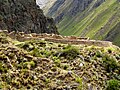 Willkaraqay ruins on hill above Patallacta
 Workers are dwarfed by terraces, which are in turn dwarfed by the surrounding mountains


