
Petrich
Petrich
Петрич | |
|---|---|
 | |
 Coat of arms | |
 Petrich Location of Petrich | |
| Coordinates:41°23′43″N23°12′25″E/ 41.39528°N 23.20694°E | |
| Country | Bulgaria |
| Province (Oblast) | Blagoevgrad |
| Government | |
| • Mayor | Dimitar Bruchkov |
| Area | |
| • Total | 80.421 km2(31.051 sq mi) |
| Elevation | 168 m (551 ft) |
| Population (2021)[1] | |
| • Total | 26,778 |
| • Density | 330/km2(860/sq mi) |
| Time zone | UTC+2(EET) |
| • Summer (DST) | UTC+3(EEST) |
| Postal Code | 2850 |
| Area code | (+359) 0745 |
| Website | Official website |
Petrich(Bulgarian:Петрич[ˈpɛtrit͡ʃ])is a towninBlagoevgrad Provincein southwesternBulgaria,located inSandanski–Petrich Valleyat the foot of theBelasicaMountains in theStrumeshnitsaValley. According to the 2021 census, the town has 26,778 inhabitants.[1]
It is the seat ofPetrich Municipality.
Petrich is located close to the borders withGreeceandNorth Macedonia.The crossing into North Macedonia is known asNovo Selo-Petrich,as the first settlement across the border isNovo Selo.
Petrich PeakonLivingston Islandin theSouth Shetland Islands,Antarcticais named for Petrich.
History
[edit]
Petrich was included in the territory of theBulgarian Stateduring the reign of KnyazBoris I(r. 852–889). During theMiddle Agesit was a Bulgarian fortress of importance during TsarSamuil's wars (r. 997–1014) withByzantium.DuringOttomanrule, it formed part of theRumeli Eyalet,and in the 19th century became akazaof theSanjak of Serresin theSalonica Vilayet.From 19 January 1892, Petrich and its district were included in theBulgarian Exarchate,before being included in Bulgaria following theBalkan Warsin 1912–13.
In October 1925 it was the site of a brief conflict between Greece and Bulgaria sometimes called theWar of the Stray Dog.
Antiquity
[edit]Petrich is one of the old towns in the valley of the middleStruma.According to local historians, the present-day town of Petrich is the heir to the ancient Thracian settlement located at the southern foot of theKozhuh hill.In this area, located 10 km northeast of the modern city, in the 4th century BC, a Thracian settlement of theMeditribe emerged. In the 1st century BC. theRomansconquered the lands of the Medes and then the small settlement near Kozhuh became a well-fortifiedRoman city- a fortress that protected the middle reaches of theStrumaand Rupel gorge. According to the interpretation of the Roman historian Titus Livy, it is assumed that this city was called Petra. Archaeological excavations show that it existed until the 6th century, when it was burned by theSlavs.It is assumed that the remaining living inhabitants left the burned town and settled at the foot of the nearby mountainBelasitsa,which marked the beginning of today's town of Petrich, adding to the old name the Slavic ending "-ich".
Recent archaeological research and the location of the ancient city ofHeraclea Sinticain theKozhuharea prove that there is no continuity between this city, located in the lands of the Thracian Sinti tribe, and modern Petrich, but a hiatus of several centuries. The earliest settlements on the site of the city appear only in the X - XI century. Petrich was formed as a significant settlement and regional center only at the end of the XII - XIV century.[2]
The Middle Ages
[edit]The Petrich region was annexed to theBulgarianstate in 837 as a result of the war of the Bulgarian KhanPresianagainst Byzantium. At the end of the 10th and the beginning of the 11th century, the lands around Petrich occupied an important military-strategic place inSamuel's state. In 1014, not far from today's town, in the so-called Kleidion gorge, a decisivebattletook place between the Bulgarian troops led byTsar Samueland the troops of the Byzantine EmperorBasil II.The remains of Samuel'sfortressstill remind of the blinding of the captured 14,000 Bulgarian soldiers. For this act theByzantineemperor Basil II received the nicknameBulgarian Assassin.
During the period XII - XIV century Petrich became a strong fortress - part of the fortification system in southwesternBulgaria.This is evidenced by the remains of the medieval fortressGyaur Kalesi,around which the city originally arose. At least in the XIII - XIV century the city consists of two parts - a fortress, i.e. fortified city core and unfortified outer city, but with entrance-exit arteries guarded by towers.[3]
Petrich was first mentioned in written sources in the deeds of the Serbian magnatesJovan DragašandKonstantin Dragaš,who in 1376 - 1377 donated local properties to the Russian monastery "St. Pantaleimon"inMount Athos. The town fell under Ottoman rule after 1395, when together with its surroundings it was included in theKyustendil Sanjakas a center of independentNahiyah.[4]
In the Ottoman Empire
[edit]During the years ofOttomanrule, Petrich acquired aMuslim appearance.The Bulgarians fled to the oppositeOgrazhden mountainto stay away from the arbitrariness of theTurks.The Ottoman travelerEvliya Çelebivisited Petrich in 1652 and reported that the palanquin had 240 not very well-developed houses with gardens. There are all two neighborhoods with amosque,achapel,two inns and only one bathroom. The center is a kaaza with 80 villages. There are 50 shops, which suggests the level ofcraftsandtrade.[5]
Revival struggles
[edit]During theBulgarian National Revival,Petrich rose to a new life. It fueled a stubborn struggle against Greekism to impose the Bulgarian language in schools and the church. In 1855 a Bulgarian monk fromHilendarwas appointed a teacher in the town, who, seeing that no one in Petrich spokeGreek,began teaching inBulgarian,but was soon dismissed. After 1856Pancho Popmihovopened a private school, where he taught Greek and Bulgarian.[6]In 1857, with the labor and funds of the entire Christian population of the city, the Church of the Assumption was built. A service in Greek was introduced in the temple, and a Greek school was opened in its yard. It is housed in the house of Ivan Popmanolev, donated by his wife to the Church of the Assumption.[6]
Geography
[edit]Climate
[edit]| Petrich (2004-2016) | ||||||||||||||||||||||||||||||||||||||||||||||||||||||||||||
|---|---|---|---|---|---|---|---|---|---|---|---|---|---|---|---|---|---|---|---|---|---|---|---|---|---|---|---|---|---|---|---|---|---|---|---|---|---|---|---|---|---|---|---|---|---|---|---|---|---|---|---|---|---|---|---|---|---|---|---|---|
| Climate chart (explanation) | ||||||||||||||||||||||||||||||||||||||||||||||||||||||||||||
| ||||||||||||||||||||||||||||||||||||||||||||||||||||||||||||
| ||||||||||||||||||||||||||||||||||||||||||||||||||||||||||||
Petrich has amediterranean climate(Köppen Climate ClassificationCsa) with an average annual temperature of 15.6 °C (60 °F). The town experiences some continental influence, especially in winter, which is cool, but warm for Bulgarian standards.
Petrich is the sunniest city inBulgariaslightly ahead ofSandanskiwith yearly sunshine hours exceeding 2,700 on average.
Summer is hot and sunny and it is the longest season in Petrich, lasting from May through September, even as late as October. The average summer temperature is around 25 °C. In July, the sunniest month, Petrich receives 373 hours of sunshine, making it one of the sunniest places inContinental Europe. Winter season, around two months, starts in late December and lasts until early February. Average winter temperature is one of the highest in the country with average around 5 °C. In December, the darkest month, there are 103 hours of sunshine, on average.
Climate table:
| Climate data for Petrich (2004-2016) | |||||||||||||
|---|---|---|---|---|---|---|---|---|---|---|---|---|---|
| Month | Jan | Feb | Mar | Apr | May | Jun | Jul | Aug | Sep | Oct | Nov | Dec | Year |
| Mean daily maximum °C (°F) | 9.5 (49.1) |
11.1 (52.0) |
15.6 (60.1) |
20.5 (68.9) |
26.0 (78.8) |
30.5 (86.9) |
33.5 (92.3) |
33.5 (92.3) |
28.1 (82.6) |
21.7 (71.1) |
15.5 (59.9) |
10.5 (50.9) |
21.2 (70.2) |
| Daily mean °C (°F) | 4.0 (39.2) |
5.5 (41.9) |
10.2 (50.4) |
14.8 (58.6) |
20.1 (68.2) |
24.0 (75.2) |
27.0 (80.6) |
27.0 (80.6) |
22.0 (71.6) |
16.1 (61.0) |
10.3 (50.5) |
5.1 (41.2) |
15.5 (59.9) |
| Mean daily minimum °C (°F) | 0.7 (33.3) |
1.6 (34.9) |
4.5 (40.1) |
9.1 (48.4) |
14.0 (57.2) |
17.5 (63.5) |
19.6 (67.3) |
19.6 (67.3) |
15.5 (59.9) |
10.9 (51.6) |
5.8 (42.4) |
2.6 (36.7) |
10.3 (50.5) |
| Averageprecipitationmm (inches) | 38 (1.5) |
38 (1.5) |
38 (1.5) |
38 (1.5) |
48 (1.9) |
39 (1.5) |
32 (1.3) |
28 (1.1) |
25 (1.0) |
38 (1.5) |
59 (2.3) |
50 (2.0) |
471 (18.5) |
| Mean monthlysunshine hours | 113 | 139 | 211 | 215 | 286 | 331 | 373 | 344 | 273 | 206 | 147 | 103 | 2,733 |
| Source:[7] | |||||||||||||
Economy
[edit]The town is an agricultural centre for fruit, vegetables and tobacco. It has three factories, making water level detectors, details for cranes and a furniture factory.
Broadcasting station
[edit]There is a 500 kW mediumwave broadcasting station working on 747 kHz. It uses as antenna a 205-metre-tallguyed mastinsulated with an additionalcage antenna.This mast was built in 1977.
International relations
[edit]- Twin towns - Sister cities
 Serres,Greece
Gallery
[edit]-
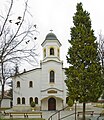 "St Bogoroditsa" Church
 -
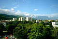
 Central Petrich
 -
 Petrich andBelasica
 -
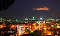 Petrich at night
 -
 Petrich andPirin Mountains
 -
 The house ofVangain Petrich


References
[edit]- ^ab"Население по градове и пол".
- ^Georgi Mitrev (2005)."Again on the Letter of Galerius and Caesar Maximinus Daya to the Heracles and the Location of Heraclea Cynthia".Archeology Magazine.Vol. XLVI, no. 1–4. pp. 181–187.
- ^Tsvetkov, Boris. "The settlement network in the valley of Sredna Struma during the Middle Ages, IX - XVIII century", Sofia, 2002, p. 62]
- ^Matanov, Hristo. "Southwestern Bulgarian lands in the XIV century", Sofia, 1986
- ^Evliya Tchelebi (1972),Travelogue,Sofia, pp. 280–282
{{citation}}:CS1 maint: location missing publisher (link) - ^abTasev, Hristo (1987), "Struggle for national education in the Melnik region",Narodna prosveta,Sofia, p. 29
- ^"Архив-Бг3 »".
External links
[edit]- Petrich.bg
- Petrich, information and photos
- Petrich municipality at Domino.bg
- Guide to Petrich municipality – cities, villages, regions


| International | |
|---|---|
| National | |
| Geographic | |