Plougastel Bridge
You can helpexpand this article with text translated fromthe corresponding articlein French.(September 2012)Click [show] for important translation instructions.
|
Plougastel Bridge Pont Albert-Louppe | |
|---|---|
 | |
| Coordinates | 48°23′14″N4°23′59″W/ 48.38722°N 4.39972°W |
| Crosses | L'Élorn |
| Characteristics | |
| Design | Arch bridge fixed at two levels |
| Material | Reinforced concrete |
| Total length | 888m |
| Width | 9m |
| Height | 27.5m |
| History | |
| Architect | Eugène Freyssinet |
| Constructed by | Direction départementale de l'Équipement du Finistère |
| Fabrication by | Entreprises Limousin |
| Construction start | 1926 |
| Construction end | 1930 |
| Inaugurated | 1930 |
| Location | |
 | |
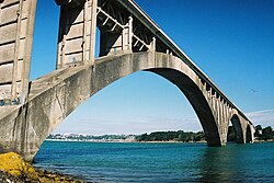
ThePlougastel Bridge,orAlbert-Louppe Bridge,is abridgeover the riverÉlornnearBrest,France,connectingPlougastel-DaoulasandLe Relecq-Kerhuon.
Construction on the Plougastel Bridge started in 1926 and was completed on 9 October 1930. Part of it was destroyed by theGermanarmy in 1944, and shortly after was closed for repair. It was reopened after the widening and construction five years later. Between 1991 and 1994 another bridge, thePont de l'Iroise,was built parallel to this bridge. Today the Plougastel carries tractor, pedestrian and bicycle traffic and is a landmark on the route of theParis–Brest–Parisbicycle event.
The Plougastel Bridge is anarch bridge,or has a fixed,double deck structure.The arches are composed of concrete and have a total length of around 888m. The three major spans are 188 m[1]but sometimes said to be 186 m.[2]
The engineer who constructed the bridge was namedEugène Freyssinet,and the president of the committee managing the project wasAlbert Louppe,an explosives engineer who pursued a parallel career in politics, becoming theSenatorforFinistèrein 1921. Louppe died in 1927, one year after work on constructing the bridge finally began.
References
[edit]- ^Plougastel BridgeatStructurae
- ^"Pont de l'Harteloire".brueckenweb.de(in German).
External links
[edit]
