Pohuwato Regency
Pohuwato Regency
Kabupaten Pohuwato | |
|---|---|
 | |
| Coordinates: 0° 31 59 N, 121° 49 30 E | |
| Country | Indonesia |
| Province | Gorontalo |
| Capital | Marisa |
| Area | |
| • Total | 1,638.74 sq mi (4,244.31 km2) |
| Population (mid 2023 estimate) | |
| • Total | 160,187 |
| • Density | 98/sq mi (38/km2) |
| [1] | |
| Time zone | UTC+8:00 |
| • Summer (DST) | UTC+8:00 |
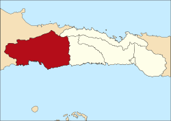
Pohuwatois aregencyofGorontalo Province,Indonesia.It is located on the northern (or Minahasa) peninsula of the island ofSulawesi.It was established on 25 February 2003 under Law Number (Undang-Undang Nomor) 6/2003 by splitting off from the western part ofBoalemo Regency.It has an area of 4,244.31 km2,and had a population of 128,748 at the 2010 Census[2]and 146,432 at the 2020 Census;[3]the official estimate as at mid 2023 was 160,187 (comprising 81,612 males and 78,575 females).[1]The seat of the regency administration is in the town ofMarisa.
History
[edit]On 21 September 2023, Pohuwato regent office and Regional People's Representative Council building were burned by local miners. They demanded PT Pani Gold Project (PGP) or PT Puncak Emas Tani Sejahtera (PETS, a subsidiary ofMerdeka Copper Gold[4]) to return the ancestral land they worked on. Previously, the protesters have raided the company's office on the same day.[5][6]The offices were later demolished on 4 December 2023.[7]
Administrative Districts
[edit]Pohuwato Regency is divided into thirteendistricts(kecamatan), tabulated below with their areas and their populations at the 2010 Census[2]and the 2020 Census,[3]together with the official estimates as at mid 2023.[1]The table also includes the locations of the district administrative centres, the number ofadministrative villagesin each district (totaling 101 ruraldesaand 3 urbankelurahan- the latter all in Paguat District), and its postal codes.
| Kode Wilayah |
Name of District (kecamatan) |
Area in km2 |
Pop'n Census 2010 |
Pop'n Census 2020 |
Pop'n Estimate mid 2023 |
Admin centre |
No. of villages |
Post codes |
|---|---|---|---|---|---|---|---|---|
| 75.04.01 | Popayato(a) | 90.92 | 9,169 | 10,313 | 11,367 | Popayato | 10 | 96466 |
| 75.04.13 | Popayato Barat (West Popayato) |
578.24 | 6,670 | 7,327 | 8,328 | Dudewulo | 7 | 96467 |
| 75.04.12 | Popayato Timur (East Popayato) |
723.74 | 7,712 | 8,372 | 9,132 | Maleo | 7 | 96467 |
| 75.04.02 | Lemito(b) | 619.50 | 10,488 | 11,306 | 12,099 | Lemito | 8 | 96468 |
| 75.04.11 | Wanggarasi | 188.08 | 4,573 | 5,304 | 5,907 | Limbula | 7 | 96465 & 96469 |
| western half | 2,200.48 | 38,612 | 42,622 | 46,833 | 39 | |||
| 75.04.04 | Marisa(c) | 34.65 | 17,680 | 21,260 | 23,271 | Botubilatahu Indah | 8 | 96365 |
| 75.04.06 | Patilanggio | 298.82 | 8,686 | 9,763 | 10,605 | Suka Makmur | 6 | 96366 |
| 75.04.09 | Buntulia | 375.64 | 10,494 | 11,792 | 13,199 | Buntulia Utara | 7 | 96363 |
| 75.04.10 | Duhiadaa | 39.53 | 10,662 | 12,793 | 14,150 | Buntulia Barat | 8 | 96364 |
| 75.04.03 | Randangan | 331.90 | 14,995 | 16,959 | 19,078 | Motolohu | 13 | 96469 |
| 75.04.07 | Taluditi | 159.97 | 7,248 | 8,813 | 9,299 | Panca Karsa II | 7 | 96464 |
| 75.04.05 | Paguat(d) | 560.93 | 14,967 | 16,165 | 17,096 | Bohu Jaya | 11(e) | 96362 |
| 75.04.08 | Dengilo | 242.39 | 5,404 | 6,265 | 6,656 | Popaya | 5 | 96361 |
| eastern half | 2,043.83 | 90,135 | 103,810 | 113,354 | 65 | |||
| Totals | 4,244.31 | 128,748 | 146,432 | 160,187 | Marisa | 104 |
Notes: (a) including 17 offshore islands. (b) including 25 offshore islands. (c) including 3 offshore islands. (d) including 3 offshore islands. (e) comprising 3kelurahan(Libuo, Pentadu and Siduan) and 8desa.
References
[edit]- ^abcBadan Pusat Statistik, Jakarta, 28 February 2024,Kabupaten Pohuwato Dalam Angka 2024(Katalog-BPS 1102001.7504)
- ^abBiro Pusat Statistik, Jakarta, 2011.
- ^abBadan Pusat Statistik, Jakarta, 2021.
- ^"Nilai Investasi MDKA Rp10 Triliun di Pohuwato, Ternyata Gunung Pani Punya Emas Sebanyak Ini".hulondalo.id.Retrieved2023-09-21.
- ^"Penambang Pohuwato Serbu Kantor PT PETS, Fasilitas dan Mobil Perusahaan Dirusak".tribunnews.Retrieved2023-09-21.
- ^"4 Fakta Unjuk Rasa di Kabupaten Pohuwato, Gorontalo Berakhir Ricuh, Ini Duduk Perkaranya".liputan6.Retrieved2023-09-21.
- ^"Gedung Kantor Bupati Pohuwato yang Dibakar Penambang Akhirnya Dibongkar".abstrak.id.Retrieved2023-09-06.
0°31′59″N121°49′30″E/ 0.53306°N 121.82500°E

