
Pont Royal
Pont Royal | |
|---|---|
 Pont Royal | |
| Coordinates | 48°51′36.35″N02°19′47.56″E/ 48.8600972°N 2.3298778°E |
| Carries | Motor vehicles, pedestrians, and bicycles |
| Crosses | The Seine River |
| Locale | Paris,France |
| Next upstream | Pont du Carrousel |
| Next downstream | Passerelle Léopold -Sédar-Senghor |
| Characteristics | |
| Design | Arch Bridge |
| Total length | 110 m |
| Width | 17 m[1] |
| History | |
| Construction start | 1685 |
| Construction end | 1689 |
| Statistics | |
| Toll | Free both ways |
| Location | |
 | |
ThePont Royalis abridgecrossing the riverSeineinParis.It is the third oldest bridge in Paris, after thePont Neufand thePont Marie.
Location
[edit]The Pont Royal links theRight Bankby thePavillon de Florewith theLeft Bankof Paris betweenrue du Bacand therue de Beaune.The bridge is constructed with five elliptical archesen plein cintre.A hydrographic ladder, indicating floods' highest level in Paris, is visible on the last pier nearest each bank.

Access
[edit]| Located near theMétro station:Tuileries. |
History
[edit]In 1632, the entrepreneurPierre Pidoudirected the construction of a wooden toll-bridge which would be calledPont Sainte-Anne(in deference toAnne of Austria) orPont Rouge(due to its color). It was designed to replace the Tuileries ferry upon which therue du Bac(bacmeaningferryin French) owes its name. The ferry had been offering crossings since 1550. Fragile, this bridge of fifteen arches would be repaired for the first time in 1649, completely redone two years later, burnt in 1654, flooded in 1656, completely rebuilt in 1660, propped up in 1673 and finally carried away by a flood in February 1684.Madame de Sévignéreported that this last incident caused the loss of eight of the bridge's arches.
The bridge was finally reconstructed between 25 October 1685 and 13 June 1689, this time withstone,receiving complete financing from KingLouis XIV.It was the king who gave it the namePont Royal.Louvois,director of theBâtiments du Roi,chargedJacques Gabriel,Jules Hardouin-MansartandFrançois Romainwith the construction project. In the 18th century, the bridge was a popular meeting place for various festivities and celebrations.

At the time of theFrench Revolution,in the period following the fall of the monarchy on 10 August 1792 and the beginning of theFirst French Empirein 1804 - the name of Pont Royal was changed to Pont National. During that period, GeneralNapoléon Bonaparte(future Napoléon I,Emperor of the French) had cannons installed on the bridge in order to protect theConvention Nationaleand theCommittee of Public Safety,housed in theTuileriesPalace.
During the First French Empire (1804-1814), Napoléon I renamed the bridge thePont des Tuileries,a name that was kept until theRestorationin 1814 whenLouis XVIIIgave back to the bridge its royal name.
The bridge underwent a last reconstruction in 1850. In 1939, it was classified as amonument historique.[2]
In 2005, thePont Royalwas illuminated by lights at night as one of theParis Olympic Bidhighlights.
Gallery
[edit]-
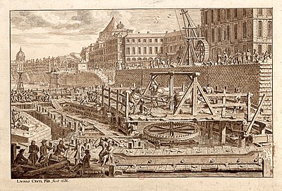 Construction of the bridge in 1686
 -
 Construction of the bridge in 1687
 -
 The bridge and thePavillon de Florein 1814
 -
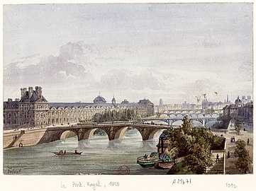 The Pont Royal in 1850
 -
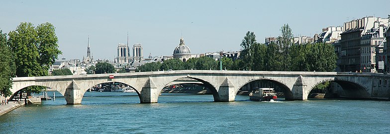
 View from thePasserelle Solférino
 -
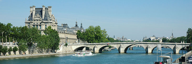
 Pont Royal and Musée d'Orsay
 -

-
-


See also
[edit]References
[edit]- ^Structure data
- ^Base Mérimée:PA00086000,Ministère français de la Culture.(in French)Pont-Royal
This article was mainly derived from theFrench Articleof the same name.
External links
[edit]- Deck arch bridges
- Bridges over the River Seine in Paris
- Monuments historiques of Paris
- Tourist attractions in Paris
- Buildings and structures in the 1st arrondissement of Paris
- Buildings and structures in the 7th arrondissement of Paris
- Stone bridges in France
- Bridges completed in the 17th century
- Transport infrastructure completed in 1632
- Former toll bridges in France
- 1632 establishments in France