Portal:Weather
The weather portal
Weatheris the state of theatmosphere,describing for example the degree to which it is hot or cold, wet or dry, calm or stormy, clear orcloudy.OnEarth,most weather phenomena occur in the lowest layer of the planet'satmosphere,thetroposphere,just below thestratosphere.Weather refers to day-to-day temperature,precipitation,and other atmospheric conditions, whereasclimateis the term for the averaging of atmospheric conditions over longer periods of time. When used without qualification, "weather" is generally understood to mean the weather of Earth.
Weather is driven byair pressure,temperature,andmoisturedifferences between one place and another. These differences can occur due to theSun's angleat any particular spot, which varies withlatitude.The strong temperature contrast between polar and tropical air gives rise to the largest scaleatmospheric circulations:theHadley cell,theFerrel cell,thepolar cell,and thejet stream.Weather systems in themiddle latitudes,such asextratropical cyclones,are caused by instabilities of the jet streamflow. Because Earth'saxis is tiltedrelative to itsorbital plane(called theecliptic),sunlightis incident atdifferent anglesat different times of the year. On Earth's surface, temperatures usually range ±40 °C (−40 °F to 104 °F) annually. Over thousands of years, changes in Earth'sorbitcan affect the amount and distribution ofsolar energyreceived by Earth, thus influencing long-term climate and globalclimate change.
Surface temperature differences in turn cause pressure differences. Higher altitudes are cooler than lower altitudes, as most atmospheric heating is due to contact with the Earth's surface while radiative losses to space are mostly constant.Weather forecastingis the application of science and technology to predict the state of theatmospherefor a future time and a given location. Earth's weather system is achaotic system;as a result, small changes to one part of the system can grow to have large effects on the system as a whole. Human attempts tocontrol the weatherhave occurred throughout history, and there is evidence thathuman activitiessuch as agriculture and industry have modified weather patterns.
Studying how the weather works on other planets has been helpful in understanding how weather works on Earth. A famous landmark in theSolar System,Jupiter'sGreat Red Spot,is ananticyclonic stormknown to have existed for at least 300 years. However, the weather is not limited to planetary bodies. Astar's coronais constantly being lost to space, creating what is essentially a very thin atmosphere throughout the Solar System. The movement of mass ejected from theSunis known as thesolar wind.(Full article...)
Selected article
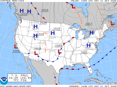
Asurface weather analysisis a type ofweather mapwhich provides a view of weather elements at a specified time based on information from ground-based weather stations. Weather maps are created by plotting or tracing the values of relevant quantities such assea level pressure,temperature,andcloud coveronto ageographical mapto help findsynoptic scalefeatures such asweather fronts.
The first weather maps in the 19th century were drawn well after the fact to help devise a theory on storm systems. After the advent of the telegraph, simultaneous observations of weather became possible for the first time, and beginning in the late 1840s, theSmithsonian Institutionbecame the first organization to draw real-time surface analyses. Use of surface analyses began first in the United States, spreading worldwide during the 1870s. Use of the Norwegian cyclone model for frontal analysis began in the late 1910s across Europe, with its use finally spreading to the United States during World War II.
Surface weather analyses have special symbols which show frontal systems, cloud cover,precipitation,or other important information. For example, anHmay representhigh pressure,implying good and fair weather. AnLon the other hand may representlow pressure,which frequently accompanies precipitation. Various symbols are used not just for frontal zones and other surface boundaries on weather maps, but also to depict the present weather at various locations on the weather map. The surface weather analysis is useful for visualizing general trends in the weather across a relatively large geographic area.
Recently selected articles:Snow in Florida,Great Lakes Storm,More...
Did you know(auto-generated)-

- ... thatextreme event attributionestimates how muchclimate changecauses weather events, such as the2021 Western North America heat wave?
- ... that Japanese actor Kouhei Higuchi prepared for his role on the television drama adaptation ofMy Personal Weathermanby learning from a weather forecaster?
- ... thatthe weather forecastforHD 189733 bis "Westerly winds at 2000 m/s, with molten glass showers"?
- ... thatan attempted British-Norwegian attackon theGerman battleshipTirpitzwas abandoned after twoChariot manned torpedoeswere lost due to bad weather?
- ... that in the 1980s, "Sherman Bonner, The Human Thermometer" presented the weather onan Arkansas TV station?
- ... that after Irish post office clerkMaureen Flavin Sweeneyreported worsening weather conditions,Dwight D. Eisenhoweragreed to postpone D-Day by 24 hours?
Selected image

Flakes ofsnowhighly magnified by a low-temperaturescanning electron microscope(SEM). The colors are called "pseudo colors"; they are computer generated and are a standard technique used with SEM images.
Recently selected pictures:Sun dog,Pyrocumulus clouds,Cloud-to-cloud lightning,More...
More did you know...
...that theFlying riveris the name given to the transport ofwater vaporfrom theAmazon rainforestto southernBrazil?
...thathurricane shuttersare required for all homes inFloridaunless impact-resistant glass is used?
...that theJoint Institute for Marine and Atmospheric Researchis a combined weather and ocean research institute with the cooperation of theOffice of Oceanic and Atmospheric Researchand theUniversity of Hawaiʻi?
...that theSS Central Americawas sunk by ahurricanewhile carrying more than 30,000 pounds (13,600 kg) of gold, contributing to thePanic of 1857?
...that ahurricane force wind warningis issued by theUnited StatesNational Weather Servicefor storms that are nottropical cyclonesbut are expected to produce hurricane-force winds (65 knots (75 mph; 120 km/h) or higher)?
...that theAutomated Tropical Cyclone Forecasting Systemis a software package fortropical cycloneforecastingdeveloped in 1988 that is still used today bymeteorologistsin various branches of theUS Government?
Recent and ongoing weather
- Wikinews weather portal
- March 26,2021:Tropical moisture ceases to cause severe floods in South East Australia
- February 19,2021:Winter storms hammer Texas, fatalities reported
- December 28,2021:Typhoon Phanfone strikes Philippines
- February 1,2022:Deadly floods in Brazil after heavy rainfall
- April 15,2022:South African floods kill at least 300 people
- Weather of 2024
- 2024 Atlantic hurricane season
- 2020–21 North American winter
- 2024 Pacific typhoon season
- Tornadoes of 2024
This week in weather history...
July 5
1805:Robert FitzRoy,captain of theHMSBeagleand a pioneering Britishmeteorologist,was born inSuffolk,England.
July 6
2013:Hurricane Erickreached peak intensity as it passed 100 miles (160 km) offshore ofLázaro Cárdenas, Michoacán,Mexico.Though the storm did not makelandfall,flooding rains lead to the deaths of at least two people.
July 7
1991:Amajor derechoraced fromSouth DakotatoNew York,killing one person and causing over $100 million in damage.
July 8
1980:Aeroflot Flight 4225crashed shortly after takeoff fromAlmaty International AirportinSoviet Kazakhstandue toturbulencecaused bythermalsduring aheat wave,killing all 166 people on board.
July 9
1986:Typhoon Peggymade landfall in northernLuzon,Philippines,killing more than 300 people.
July 10
2005:Hurricane Dennisreached peak intensity with a central pressure of 930 millibars (27.46 inHg), making it the strongestAtlantic hurricaneto form prior to August. This record was broken byHurricane Emilyonly 6 days later.
July 11
1892:TheTête Rousse Glacieron theMont Blanc massifunleashed anoutburst floodof meltwater, killing at least 200 people in the valley nearSaint-Gervais-les-Bains,France.
Selected biography
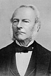
Sir George Gabriel Stokes, 1st Baronet,FRS(⫽stoʊks⫽;13 August 1819 – 1 February 1903) was anIrishphysicistandmathematician.Born inCounty Sligo,Ireland, Stokes spent all of his career at theUniversity of Cambridge,where he was theLucasian Professor of Mathematicsfrom 1849 until his death in 1903. As a physicist, Stokes made seminal contributions tofluid mechanics,including theNavier–Stokes equations;and tophysical optics,with notable works onpolarizationandfluorescence.As a mathematician, he popularised "Stokes' theorem"invector calculusand contributed to the theory ofasymptotic expansions.Stokes, along withFelix Hoppe-Seyler,first demonstrated the oxygen transport function ofhaemoglobin,and showed colour changes produced by the aeration of haemoglobin solutions.
Stokes was made abaronetby the British monarch in 1889. In 1893 he received theRoyal Society'sCopley Medal,then the most prestigious scientific prize in the world, "for his researches and discoveries in physical science". He representedCambridge Universityin theBritish House of Commonsfrom 1887 to 1892, sitting as aConservative.Stokes also served as president of the Royal Society from 1885 to 1890 and was briefly theMasterofPembroke College, Cambridge.Stokes's extensive correspondence and his work as Secretary of the Royal Society has led him to be referred to as a gatekeeper of Victorian science, with his contributions surpassing his own published papers. (Full article...)
Previously selected biographies:Clement Lindley Wragge,Robert Case,More...
Related portals
Quality content
Other candidates:
- Featured Article Review:2005 Atlantic hurricane season(Discussion)
- Featured List Removal Candidate:List of storms in the 2005 Atlantic hurricane season(Discussion)
Subcategories
WikiProjects
The scope ofWikiProject Weatheris to have a single location for all weather-related articles on Wikipedia.
WikiProject Meteorologyis a collaborative effort by dozens of Wikipedians to improve the quality ofmeteorology- andweather-related articles. If you would like to help, visit theproject talk page,and see what needs doing.
WikiProject Severe weatheris a similar project specific to articles aboutsevere weather.Their talk page is locatedhere.
WikiProject Tropical cyclonesis a daughter project of WikiProject meteorology. The dozens of semi-active members and several full-time members focus on improving Wikipedia's coverage oftropical cyclones.
WikiProject Non-tropical stormsis a collaborative project to improve articles related to winter storms, wind storms, and extratropical cyclones.
Wikipedia is a fully collaborative effort by volunteers. So if you see something you think you can improve,be boldand get to editing! We appreciate any help you can provide!
Associated Wikimedia
The followingWikimedia Foundationsister projects provide more on this subject:
-
Commons
Free media repository -
Wikibooks
Free textbooks and manuals -
Wikidata
Free knowledge base -
Wikinews
Free-content news -
Wikiquote
Collection of quotations -
Wikisource
Free-content library -
Wikiversity
Free learning tools -
Wiktionary
Dictionary and thesaurus

