
Posadas, Misiones
This articleneeds additional citations forverification.(May 2013) |
Posadas | |
|---|---|
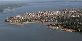
 (From top to bottom; from left to right) Panoramic view of the city;San Roque Bridge;Misiones Government House; Posadas Plaza Shopping Centre and the Malvinas Monument | |
 Flag | |
 Posadas Location of Posadas in Argentina  Posadas Posadas (Argentina) | |
| Coordinates:27°22′S55°54′W/ 27.367°S 55.900°W | |
| Country | |
| Province | |
| Department | Capital |
| Founded | 1870 |
| Government | |
| •Intendant | Leonardo Stelatto (Frente Renovador) |
| Elevation | 120 m (390 ft) |
| Population (2010 census & 2017 estimates) | |
| •Urban | 275,028 |
| •Metro | 359,609 |
| Time zone | UTC−3(ART) |
| CPA base | N3300 |
| Dialing code | +54 376 |
| Website | posadas |
Posadas(Spanish pronunciation:[poˈsaðas]) is the capital city of theArgentineprovinceofMisiones,in its south, at the far north-west of the country on theleft bankof theParaná River,oppositeEncarnación, Paraguay.The city has an area of 965 square kilometres (373 sq mi) and a population of 324,756 (2010census[INDEC]), and the Greater Posadas area has a population of over 359,609 according to a 2017 estimate ("IPEC".26 April 2018.).
Posadas is the provincial centre of the government, culture and the economy. Furniture, tobacco, food, textiles and construction are its most important industries. Other important economic activities are commerce and services.
Posadas is connected to theParaguayancity of Encarnación by theSan Roque González de Santa Cruz Bridge.The port, once of great economical importance, is used for sport vessels, carrier of passengers and some boats for sand transport. The city is located onNational Route 12,some 1,300 kilometres (810 mi) fromBuenos Aires.TheGeneral José de San Martín Airport(IATA:PSS,ICAO:SARP), at coordinates27°22′S55°58′W/ 27.367°S 55.967°W,is seven kilometres from the city, and features regular flights to Buenos Aires.
History[edit]
FatherRoque González y de Santa Cruzestablished a town called Anunciación de Itapúa on 25 March 1615, but ten years later the settlement was moved to the other side of theParaná Riverto the present location ofEncarnación, Paraguay.
The first settlement was not completely abandoned, and a new San José reduction was settled there in 1628. In 1867, during theParaguayan War,the Brazilians set up the Trinchera de San José military base there. Following the end of the war, Paraguay renounced all claims to the area, and in 1879, the town was renamed afterGervasio Antonio de Posadas,the Supreme Director of theArgentine Confederation(1814).
On 22 December 1881, the limits of the Misiones Federation were drawn, leaving Posadas within the territory of currentCorrientes Province.On 30 July 1884 theNational Congressdecided to give Posadas to Misiones Province, and name it its capital. TheNational University of Misioneswas established at Posadas in 1973, and in 1990, the city's cultural and economic links to Encarnación were strengthened with the completion of theSan Roque González de Santa Cruz Bridge.
Public transportation[edit]
The average amount of time people spend commuting with public transit in Posadas, for example to and from work, on a weekday is 57 min. 10% of public transit riders, ride for more than 2 hours every day. The average amount of time people wait at a stop or station for public transit is 16 min, while 26% of riders wait for over 20 minutes on average every day. The average distance people usually ride in a single trip with public transit is 4.3 km, while 2% travel for over 12 km in a single direction.[1]
Climate[edit]
| Posadas | ||||||||||||||||||||||||||||||||||||||||||||||||||||||||||||
|---|---|---|---|---|---|---|---|---|---|---|---|---|---|---|---|---|---|---|---|---|---|---|---|---|---|---|---|---|---|---|---|---|---|---|---|---|---|---|---|---|---|---|---|---|---|---|---|---|---|---|---|---|---|---|---|---|---|---|---|---|
| Climate chart (explanation) | ||||||||||||||||||||||||||||||||||||||||||||||||||||||||||||
| ||||||||||||||||||||||||||||||||||||||||||||||||||||||||||||
| ||||||||||||||||||||||||||||||||||||||||||||||||||||||||||||
Posadas has ahumid subtropical climate(KöppenCfa). Summers are hot and humid with lows around 21 °C (69.8 °F), highs around 31.5 °C (88.7 °F), daily mean 26.0 °C (78.8 °F), and frequent thunderstorms. Winters are warm with lows around 12 °C (53.6 °F) and highs around 22.5 °C (72.5 °F), daily mean 17 °C (62.6 °F). The highest temperature ever recorded was 42.1 °C (107.8 °F) and the coldest was −2.8 °C (27.0 °F).[2]
| Climate data forPosadas Airport(1991–2020, extremes 1961–present) | |||||||||||||
|---|---|---|---|---|---|---|---|---|---|---|---|---|---|
| Month | Jan | Feb | Mar | Apr | May | Jun | Jul | Aug | Sep | Oct | Nov | Dec | Year |
| Record high °C (°F) | 42.5 (108.5) |
40.7 (105.3) |
39.5 (103.1) |
36.2 (97.2) |
34.8 (94.6) |
31.3 (88.3) |
33.0 (91.4) |
38.2 (100.8) |
39.3 (102.7) |
40.6 (105.1) |
41.7 (107.1) |
42.1 (107.8) |
42.5 (108.5) |
| Mean daily maximum °C (°F) | 33.0 (91.4) |
32.4 (90.3) |
31.0 (87.8) |
28.0 (82.4) |
23.9 (75.0) |
22.2 (72.0) |
22.0 (71.6) |
24.5 (76.1) |
25.9 (78.6) |
28.5 (83.3) |
30.4 (86.7) |
32.3 (90.1) |
27.8 (82.0) |
| Daily mean °C (°F) | 27.2 (81.0) |
26.5 (79.7) |
25.1 (77.2) |
22.3 (72.1) |
18.6 (65.5) |
17.1 (62.8) |
16.3 (61.3) |
18.2 (64.8) |
20.0 (68.0) |
22.6 (72.7) |
24.4 (75.9) |
26.5 (79.7) |
22.1 (71.8) |
| Mean daily minimum °C (°F) | 22.1 (71.8) |
21.7 (71.1) |
20.4 (68.7) |
17.7 (63.9) |
14.4 (57.9) |
13.1 (55.6) |
11.8 (53.2) |
13.3 (55.9) |
15.0 (59.0) |
17.6 (63.7) |
18.9 (66.0) |
21.1 (70.0) |
17.3 (63.1) |
| Record low °C (°F) | 10.5 (50.9) |
10.3 (50.5) |
5.7 (42.3) |
4.3 (39.7) |
0.6 (33.1) |
−1.5 (29.3) |
−2.8 (27.0) |
−1.8 (28.8) |
1.3 (34.3) |
4.8 (40.6) |
6.9 (44.4) |
9.6 (49.3) |
−2.8 (27.0) |
| Averageprecipitationmm (inches) | 168.7 (6.64) |
136.9 (5.39) |
171.0 (6.73) |
179.0 (7.05) |
138.4 (5.45) |
128.6 (5.06) |
94.1 (3.70) |
87.1 (3.43) |
132.8 (5.23) |
253.4 (9.98) |
178.8 (7.04) |
204.4 (8.05) |
1,873.2 (73.75) |
| Average precipitation days(≥ 0.1 mm) | 9.5 | 9.2 | 9.3 | 8.9 | 8.8 | 8.5 | 8.1 | 7.6 | 9.9 | 11.5 | 8.9 | 9.7 | 110.0 |
| Averagerelative humidity(%) | 68.1 | 70.4 | 71.9 | 74.4 | 77.3 | 77.5 | 73.9 | 68.3 | 67.9 | 69.6 | 65.4 | 66.3 | 70.9 |
| Mean monthlysunshine hours | 192.2 | 186.5 | 179.8 | 174.0 | 155.0 | 126.0 | 158.1 | 179.8 | 147.0 | 153.0 | 183.0 | 176.7 | 2,011.1 |
| Mean dailysunshine hours | 6.2 | 6.6 | 5.8 | 5.8 | 5.0 | 4.2 | 5.1 | 5.8 | 4.9 | 5.1 | 6.1 | 5.7 | 5.5 |
| Percentpossible sunshine | 59 | 58 | 45 | 57 | 55 | 46 | 48 | 46 | 31 | 50 | 54 | 54 | 50 |
| Source 1:Servicio Meteorológico Nacional[3][4][5] | |||||||||||||
| Source 2: UNLP (percent sun only)[6] | |||||||||||||
Notable people[edit]
- José Acasuso(born 1982), tennis player
- Germán Cano(born 1988), soccer player
- Alberto Mancini(born 1969), tennis player
- Mariano Messera(born 1978), soccer player
- Daniel Vancsik(born 1977), golf player
- Lucina von der Heyde(born 1997), field hockey player
Sports[edit]
The city's mainfootballteams are:CD Guaraní Antonio Franco,CA Bartolomé Mitre,CA PosadasandCD Jorge Gibson Brown.
Gallery[edit]
-
 Posadas, Argentina
 -
 Posadas, Argentina
 -
 Posadas, Argentina


Sister cities[edit]
- Bergamo,Italy[7]
- Encarnación,Paraguay[8]
References[edit]
- ^"Posadas Public Transportation Statistics".Global Public Transit Index by Moovit.Retrieved19 June2017.
 Material was copied from this source, which is available under aCreative Commons Attribution 4.0 International License.
- ^"Datos Estadísticos (Período 1981–1990)"(in Spanish). National Meteorological Service of Argentina.Retrieved23 August2012.
- ^"Estadísticas Climatológicas Normales – período 1991–2020"(in Spanish). Servicio Meteorológico Nacional.Retrieved8 April2023.
- ^"Estadísticas Climatológicas Normales – período 1991–2020"(PDF)(in Spanish). Servicio Meteorológico Nacional. 2023. Archived fromthe originalon 8 July 2023.Retrieved1 August2023.
- ^ "Clima en la Argentina: Guia Climática por Posadas Aero".Caracterización: Estadísticas de largo plazo(in Spanish). Servicio Meteorológico Nacional.Retrieved8 April2023.
- ^ "Datos bioclimáticos de 173 localidades argentinas".Atlas Bioclimáticos(in Spanish). Universidad Nacional de La Plata.Retrieved8 April2014.
- ^"Posadas y sus hermanas"(in Spanish). Primera Edición. Archived fromthe originalon 2 April 2015.Retrieved28 March2015.
- ^"Asuntos Federales y Electorales".cancilleria.gov.ar.Archived fromthe originalon 27 May 2012.Retrieved11 January2022.
External links[edit]
- (in Spanish)Municipality of Posadas– Official website.
- (in Spanish)Municipal information:Municipal Affairs Federal Institute (IFAM), Municipal Affairs Secretariat, Ministry of Interior, Argentina.(in Spanish)
- (in Spanish)Universidad Nacional de Misiones
- Posadas Information
| International | |
|---|---|
| National | |
| Geographic | |