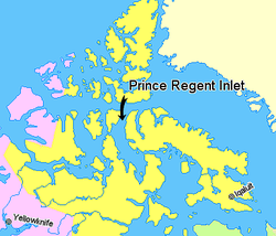
Prince Regent Inlet

Prince Regent Inlet(73°00′N090°30′W/ 73.000°N 90.500°W) is a body of water inNunavut,Canadabetween the west end ofBaffin Island(Brodeur Peninsula) andSomerset Islandon the west. It opens north intoLancaster Soundand to the south merges into theGulf of Boothia.TheArcticinlet's northern portion is approximately 40 mi (64 km) wide; the southern portion is approximately 65 mi (105 km) wide. It is deep throughout and there are no islands within the inlet.[1]
During the quest for theNorthwest Passageit was entered several times until it was realized that Prince Regent Inlet-Gulf of Boothia is a cul-de-sac for practical purposes. In 1819William Edward Parrypenetrated more than 100 miles south before turning back. In 1829John Rosspassed through it and was frozen in the Gulf of Boothia for four years before escaping. In 1852Bellot Strait,the frozen western exit, was discovered. In 1858Francis Leopold McClintocktried to pass this strait, gave up, and wintered near its mouth.
See also
[edit]References
[edit]- ^Donat Pharand (1984).The Northwest Passage: Arctic Straits.Martinus NijhoffPublishers.ISBN9789024729791.Retrieved2008-01-18.
