
Rarotonga
 NASA satellite image of Rarotonga | |
 Rarotonga  Rarotonga  Rarotonga | |
| Geography | |
|---|---|
| Location | Central-Southern Pacific Ocean |
| Coordinates | 21°14′6″S159°46′41″W/ 21.23500°S 159.77806°W |
| Archipelago | Cook Islands |
| Major islands | Motutapu, Oneroa, Koromiri, Taakoka |
| Area | 67.39 km2(26.02 sq mi) |
| Highest elevation | 2,139 ft (652 m) |
| Highest point | Te Manga |
| Administration | |
| Largest settlement | Avarua(pop. 4,906) |
| Demographics | |
| Demonym | Rarotongan |
| Population | 13,007[1] |
Rarotongais the largest and most populous of theCook Islands.The island is volcanic, with an area of 67.39 km2(26.02 sq mi), and is home to almost 75% of the country's population, with 10,898 of a total population of 15,040.[2]TheCook Islands' Parliamentbuildings andinternational airportare on Rarotonga. Rarotonga is a very popular tourist destination with many resorts, hotels and motels. The chief town,Avarua,on the north coast, is the capital of the Cook Islands.
CaptainJohn Dibbs,master of the colonial brigEndeavour,is credited as the European discoverer on 25 July 1823, while transporting the missionary ReverendJohn Williams.
Geography[edit]

Rarotonga is a kidney-shapedvolcanic island,32 km (20 mi) in circumference, and 11.2 km (7.0 mi) wide on its longest (east-west) axis.[3]The island is the summit of an extinctPlioceneorPleistocenevolcano, which rises 5000 meters from the seafloor.[4]The island was formed between 2.3 to 1.6 million years ago, with a later stage of volcanism between 1.4 and 1.1 million years ago.[4]While its position is consistent with being formed by theMacdonald hotspot,its age is too young, and its formation is attributed to a short-livedRarotonga hotspot,[5]or to rejuvenated volcanism atAitutaki.[6]
The core of the island consists of densely forested hills cut by deep valleys, the eroded remnants of the original volcanic cone.[7]The hills are drained by a number of radial streams, including theAvatiu Streamand Takuvaine Stream.[7]Te Manga,at 658 m (2,140 ft) above sea level, is the highest peak on the island.Ikurangi,a smaller peak, overlooks the capital.
The hills are surrounded by a low coastal plain consisting of beaches, a storm ridge, lowland swamps, and alluvial deposits.[8]: 9 This in turn is surrounded by afringing reef,which ranges from 30 to 900 metres wide.[8]: 30 The reef is shallow, with a maximum depth of 1.5m,[8]: 31 and has a number of passages, notably atAvarua,Avatiuand Ngatangiia. Beyond the reef crest, the outer reef slopes steeply to deep water.[8]: 31
Thelagoonis at its widest off the southeast coast in the area of theMuri Lagoon.This area contains four small islets ormotu.From north to south, the islets are:[9]
- Motutapu, 10.5 hectares (0.041 sq mi)
- Oneroa, 8.1 hectares (0.031 sq mi)
- Koromiri, 2.9 hectares (0.011 sq mi)
- Taakoka, 1.3 hectares (0.0050 sq mi)
Another small islet, Motutoa, lies on the reef flat on the northwest coast.[8]: 33
Natural environment[edit]
The interior of the island is dominated by eroded volcanic peaks cloaked in dense vegetation. Paved and unpaved roads allow access to valleys but the interior of the island remains largely unpopulated due to forbidding terrain and lack of infrastructure.
Takitumu Conservation Area[edit]
A tract of 155 ha of land has been set aside in the south-east as the Takitumu Conservation Area to protectnative birdsand plants, especially theVulnerablekakerorior Rarotonga monarch. Otherthreatenedbirds in the conservation area include theRarotonga fruit doveandRarotonga starling.The site has been recognised as anImportant Bird Area(IBA) byBirdLife International.[10]
History[edit]
The earliest evidence of human presence in the Southern Cook Islands has been dated to around AD 1000. Oral tradition tells that Rarotonga was settled by various groups, including Ata-i-te-kura, Apopo-te-akatinatina and Apopo-te-ivi-roa in the ninth century, and Tangi'ia Nui from Tahiti and Karika from Samoa in 1250.[3]An earlyariki,Toi, is said to have builtTe Ara Nui o ToiorAra Metua,a paved road that encircles the island, though the sites adjacent to it are dated to 1530.[11]Trading contact was maintained with the Austral Islands, Samoa and the Marquesas to import basalt that was used for making local adze heads,[12]while a pottery fragment found on Ma'uke has been traced toTongataputo the west, the main island of Tonga.[13]The ultimate origin of almost all the islanders’ settlement cargo can be traced back to Southeast Asia: not just their chickens, Pacific rats, Polynesian pigs, Pacific dogs and crops, but also several kinds of lizards and snails. Among the species that are understood to have reached Rarotonga by this means are at least two species of geckos and three of skinks. Likewise, the ultimate origin of almost 30 of their crops lies in the west.[14][better source needed]

According to New ZealandMāoritradition,Kupe,the discoverer ofAotearoa,visited Rarotonga, and theMāori migration canoesTākitimu,Te Arawa,Tainui,Mātaatua,Tokomaru,Aotea,andKurahaupōpassed through on their way to Aotearoa.[3]
Fletcher Christianvisited the island in 1789 onHMSBountybut did not land.[3]Captain Theodore Walker sighted the island in 1813 on the shipEndeavour.The first recorded landing by a European was Captain Philip Goodenough withWilliam Wentworthin 1814 on the schoonerCumberland.[15]On 25 July 1823, while transporting the missionary ReverendJohn Williams,theEndeavourreturned to Rarotonga.Papeiha,aLondon Missionary Societyevangelist fromBora Bora,went ashore to teach his religion.[3]Further missionaries followed, and by 1830 the island had converted to Christianity.

From 1830 to 1850, Rarotonga was a popular stop for whalers and trading schooners,[3]and trade began with the outside world. The missionaries attempted to exclude other Europeans as a bad influence, and in 1845 Rarotonganarikiprohibited the sale of land to Europeans, though they were allowed to rent land on an annual basis.[16]Despite a further ban on foreign settlement in 1848, European traders began to settle. In 1865, driven by rumours that France planned to annex the islands, thearikiof Rarotonga unsuccessfully petitioned GovernorGeorge Greyof New Zealand for British protection.[16]In 1883 the Royal navyde factorecognised thearikiof Rarotonga as an independent government.[17]By this timeMakea Takau Arikihad become paramount among theariki,and was recognised as the "Queen of Rarotonga" on a visit to New Zealand.[17]In 1888 the island became a British protectorate after a petition from theariki.[18]In 1901, it was annexed by New Zealand.

Oranges had been introduced by theBountymutineers, and after annexation developed into a major export crop, though exports had been disrupted by poor shipping.[19]In 1945 the industry was revived with a government-led citrus replanting scheme,[20]and in 1961 a canning factory was opened to allow the export of juice.[21][22]The industry survived until the 1980s,[22]but collapsed after New Zealand adoptedRogernomicsand removed privileged market access.[23]
An airstrip was built in 1944, leading to regular flights toFiji,Tonga,SamoaandAitutaki.[3]The airport and better shipping links saw the beginnings of large-scale migration to New Zealand.[24]Emigration increased further in the early 1970's when the airport was upgraded,[25]but this was balanced by immigration from elsewhere in the Cook Islands.[24]: 48–49 [26]
Flooding in April and May 1967 damaged bridges on the island and caused widespread crop losses, raising risks of a food shortage.[27]An unnamed tropical cyclone in December of that year left hundreds homeless and caused widespread devastation after demolishing homes and offices in Avarua.[28][29]In December 1976 80% of the island's banana crop was destroyed bytropical cyclone Kim.[30]In January 1987 Tropical Cyclone Sally made a thousand people homeless and damaged 80% of the buildings in Avarua.[31][32]
Demographics and settlements[edit]
| Year | Pop. | ±% |
|---|---|---|
| 1906 | 2,441 | — |
| 1916 | 3,064 | +25.5% |
| 1926 | 3,936 | +28.5% |
| 1936 | 5,054 | +28.4% |
| 1945 | 5,573 | +10.3% |
| 1951 | 6,048 | +8.5% |
| 1961 | 8,676 | +43.5% |
| 1966 | 9,971 | +14.9% |
| 1971 | 11,478 | +15.1% |
| 1976 | 9,802 | −14.6% |
| 1981 | 9,530 | −2.8% |
| 1986 | 9,826 | +3.1% |
| 1996 | 11,225 | +14.2% |
| 2001 | 12,188 | +8.6% |
| 2006 | 13,890 | +14.0% |
| 2011 | 13,095 | −5.7% |
| 2016 | 13,007 | −0.7% |
| Source:[1] | ||


The population of Rarotonga was 13007 in 2016.[1]
The island is traditionally divided into three tribal districts orvaka.Te Au O Tonga on the northern side of the island (Avaruais the capital),Takitumuon the eastern and southern side and Puaikura on the western side. For administrative purposes it is divided into five Land Districts. The Land District ofAvaruais represented under vaka Te Au O Tonga, the Land Districts ofMatavera,NgatangiiaandTitikavekaare represented under vaka Takitumu and the Land DistrictArorangiis represented under vaka Puaikura. The districts are subdivided into 54tapere(traditional sub-districts).
In 2008, the three vaka councils of Rarotonga were abolished.[33][34]
Area attractions[edit]
Palm-studded white sandybeachesfringe most of the island, and there is a popular cross-island walk that connects Avatiu valley with the south side of the island. It passes the Te Rua Manga, the prominent needle-shaped rock visible from the air and some coastal areas. Hikes can also be taken to the Raemaru, or flat-top mountain. Other attractions include Wigmore Falls (Papua Falls) and the ancientmarae,Arai te Tonga.
Popular island activities includesnorkeling,scuba diving,bike riding, kite surfing, hiking, deep-sea fishing, boat tours, scenic flights, going to restaurants, dancing, seeing island shows,squash,tennis, zipping around on mopeds, and sleeping on the beach. There are many churches open for service on Sunday, witha cappellasinging. People congregate at the sea wall that skirts the end of the airport's runway to be "jetblasted" by aircraft.[35]
Transport[edit]
Rarotonga has three harbours,Avatiu,Avarua and Avana, of which only Avatiu harbour is ofcommercialsignificance. The Port of Avatiu serves a small fleet of inter-island and fishing vessels, with cargo ships regularly visiting fromNew Zealandvia other Pacific Islands ports. Large cruise ships regularly visit Rarotonga but the port is too small for cruise ships to enter and they are required to anchor off shore outside the harbour.

The island is encircled by a main road, Ara Tapu, that traces the coast. Three-quarters of Rarotonga is also encircled by the ancient inner road, Ara Metua. Approximately 29 km long, this road was constructed in 11th century and for most or all of its whole length was paved with large stone slabs. Along this road are several important marae, including Arai Te Tonga, the most sacred shrine in Rarotonga. Due to the mountainous interior, there is no road crossing the island. Rarotonga has only two bus routes: clockwise and anticlockwise.[36]The clockwise bus runs from morning operating an hourly schedule until a last service at 11pm. The anti-clockwise route leaves Avarua on the half-hour, with the last service at 4.30 pm. Although there are bus stops, the buses pick up and set down anywhere en route.
Rarotonga International Airportis the international airport of the Cook Islands.
Popular culture[edit]
This sectionneeds additional citations forverification.(February 2019) |
- The travel writerRobert Dean Frisbiedied on the island, after having lived there only briefly.
- The 1995 albumFinnby theFinn Brothersends with the song "Kiss the Road of Rarotonga", which was inspired by a motorcycle accident thatTim Finnhad during a visit there.
- The U.S. television seriesSurvivor: Cook Islandswas filmed on Aitutaki, one of the islands in the southern group. One of the tribes was called Rarotonga (or Raro for short).
- A number of feature-length films are linked to Rarotonga:Merry Christmas, Mr. Lawrence,depicting a Japanese POW camp for British prisoners in the island ofJavain the year 1942, was filmed here,The Other Side of Heaven,which is set inNiuatoputapu,Tonga,but was filmed in part on Rarotonga, andJohnny Lingowhich was set here.
- In the 2008 filmNim's Island,Rarotonga is portrayed as a waypoint for fictional adventure writer Alexandra Rover (Jodie Foster) on her journey from San Francisco to a South Pacific island.
- In 1951, Mexican writersYolanda Vargas Dulchéand Guillermo de la Parra wroteRarotonga,a comic book whose plot unfolds on the island. The heroine of the story is calledZonga,an Enigma tic woman with superhuman powers. The comic inspired a Mexican movie filmed in 1978 and a song by the Mexican rock bandCafé Tacuba.
- The 1948 filmAnother Shorehas as its central character an Irish civil servant who fantasises about going to live on Rarotonga.
- Smooth Walker (Howard Hesseman) books a flight to Rarotonga in the 1983 filmDoctor Detroit.
- Former New Zealand cricket captainJohn Wright's 1990 autobiography is titledChristmas in Rarotonga.[37]
Gallery[edit]
-
 Te Rua Manga (The Needle) lookout
 -
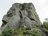 Te Rua Manga (The Needle)
 -
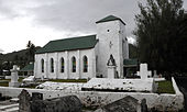 Cook Islands Christian Church(CICC) inAvarua


See also[edit]
- Auparu– in Cook Islands mythology, Auparu ( "gentle dew" ) is a stream in Rarotonga, the bathing-place of nymphs or fairies.
- Nukutere College– the country's only Roman Catholic secondary school
- Roman Catholic Diocese of Rarotonga
- Treaty of Rarotonga– 1985 South Pacific Nuclear Free Zone Treaty
References[edit]
- ^abc"Cook Islands 2016 Census Main Report"(PDF).Cook Islands Statistical Office. 2018.Retrieved10 July2021.
- ^"2021 Census of Population and Dwellings | Cook Islands Statistics Office".Retrieved26 October2023.
- ^abcdefgAlphons M.J. Kloosterman (1976).Discoverers Of The Cook Islands And The Names They Gave.pp. 44–47.
- ^abThompson, G. M.; Malpas, J.; Smith, Ian E. M. (1998)."Volcanic geology of Rarotonga, southern Pacific Ocean".New Zealand Journal of Geology and Geophysics.41(1): 95-104.doi:10.1080/00288306.1998.9514793.
- ^Clouard, Valérie; Bonneville, Alain (2001)."How many Pacific hotspots are fed by deep-mantle plumes?".Geology.29(8): 695-698.Bibcode:2001Geo....29..695C.doi:10.1130/0091-7613(2001)029<0695:HMPHAF>2.0.CO;2.ISSN0091-7613.
- ^Jackson, M G; Halldórsson, S A; Price, a; Kurz, M D; Konter, J G; Koppers, a A P; Day, J M D (5 March 2020)."Contrasting Old and Young Volcanism from Aitutaki, Cook Islands: Implications for the Origins of the Cook–Austral Volcanic Chain".Journal of Petrology.61(3).doi:10.1093/petrology/egaa037.
- ^abB. L. Wood (1967)."Geology of the Cook Islands".New Zealand Journal of Geology and Geophysics.10(6): 1431–1434.doi:10.1080/00288306.1967.10423227.Retrieved10 July2020.
- ^abcdeRichmond, Bruce M (1990)."CCOP/SOPAC Technical Report 65: Coastal morphology of Rarotonga, Cook Islands".South Pacific Applied Geoscience Commission.Retrieved10 July2021.
- ^Collins, William T (1993)."SOPAC Technical Report 181: Bathymetry and sediments of Ngatangiia Harbour and Muri Lagoon, Rarotonga, Cook Islands"(PDF).South Pacific Applied Geoscience Commission.Retrieved10 July2021.
- ^"Takitumu Conservation Area, Rarotonga".BirdLife Data Zone.BirdLife International. 2021.Retrieved8 March2021.
- ^Matthew Campbell (2002)."Ritual landscape in late pre-contact Rarotonga: a brief reading".Journal of the Polynesian Society.111(2): 147–170.Retrieved18 August2020.
- ^Weisler, Marshall I.; Bolhar, Robert; Ma, Jinlong; et al. (5 July 2016)."Cook Island artifact geochemistry demonstrates spatial and temporal extent of pre-European interarchipelago voyaging in East Polynesia".Proceedings of the National Academy of Sciences.113(29): 8150–8155.Bibcode:2016PNAS..113.8150W.doi:10.1073/pnas.1608130113.PMC4961153.PMID27382159.
- ^Richard Walter; W.R. Dickinson (1989)."A ceramic sherd from Ma'uke in the Southern Cook Islands".The Journal of the Polynesian Society.98(4): 465–470.Retrieved6 August2020.
- ^Crowe, Andrew (2018).Pathway of the Birds: The Voyaging Achievements of Māori and their Polynesian Ancestors.Auckland, New Zealand: Bateman. p. 122.ISBN9781869539610.
- ^Coppell, W. G. (1973)."About the Cook Islands. Their Nomenclature and a Systematic Statement of Early European contacts".Journal de la Société des océanistes.29(38): 43.doi:10.3406/jso.1973.2410.Retrieved18 January2018.
- ^abRichard Phillip Gilson (1980). Ron Crocombe (ed.).The Cook Islands, 1820–1950.Wellington: Victoria University press. pp. 41–43.
- ^abGilson (1980), p. 50
- ^"Protectorate Over the Cook's Group: The official ceremony performed".New Zealand Herald.Vol. XXV, no. 9227. 3 December 1888. p. 11.Retrieved20 August2020– via Papers Past.
- ^Johnston, W. B. (1951). "The Citrus Industry of the Cook Islands".New Zealand Geographer.7(2): 121-138.doi:10.1111/j.1745-7939.1951.tb01760.x.
- ^Menzies, Brian John (1970).A study of a development scheme in a Polynesian community: the citrus replanting scheme on Atiu, Cook Islands(MA). Massey University. p. 60-62.hdl:10179/13651.Retrieved8 February2021.
- ^Joseph Henry Burke (1963).Australia and New Zealand: Citrus Producers and Markets in the Southern Hemisphere.U.S. Department of Agriculture. p. 38.
- ^ab"Sweet Orange".Cook Islands Biodiversity.Retrieved24 July2021.
- ^Mark Scott (1991)."In search of the Cook Islands".New Zealand Geographic.Retrieved16 February2021.
- ^abCurson, Peter Hayden (1972)."COOK ISLANDERS IN TOWN" A STUDY OF COOK ISLAND URBANISATION(PDF)(PhD). University of Tasmania. p. 38-40.Retrieved24 July2021.
- ^Carl Walrond (8 February 2005)."Cook Islanders – Migration".Te Ara – the Encyclopedia of New Zealand.Retrieved24 July2021.
- ^Ward, R. Gerard (1961)."A note on population movements in the Cook Islands".Journal of the Polynesian Society.70(1): 1-10.Retrieved24 July2021.
- ^W. H. Perceval (1 July 1967)."Food shortage may follow RAROTONGA FLOODS PLAY HAVOC WITH FOOD CROPS".Pacific Islands Monthly.Vol. 38, no. 7. p. 75.Retrieved24 July2021– via National Library of Australia.
- ^"Hurricane lashes Cook Is. group".Canberra Times.20 December 1967. p. 10.Retrieved24 July2021– via National Library of Australia.
- ^W. H. Perceval (1 January 1968)."Devastating hurricane lashes the Cook Islands".Pacific Islands Monthly.Vol. 39, no. 1. p. 22-23.Retrieved24 July2021– via National Library of Australia.
- ^"Lashes Island".Papua New Guinea Post-Courier.15 December 1976. p. 6.Retrieved24 July2021– via National Library of Australia.
- ^"Sally's $35m trail".Canberra Times.5 January 1987. p. 5.Retrieved24 July2021– via National Library of Australia.
- ^"Hurricane Sally," Worst in Memory, "Leaves Island Devastated".AP. 5 January 1987.Retrieved24 July2021.
- ^"Cook Islands govt abolishes Rarotonga Vaka councils".2007.Retrieved1 September2015.
- ^"Statoids: Cook Islands".Retrieved1 September2015.
- ^Vaimoana Tapaleo (3 July 2015)."Tourists hurt by Air New Zealand jet blast in Rarotonga".The New Zealand Herald.ISSN1170-0777.Retrieved12 May2020.
- ^Bus & Taxis / Sokala Villas, Muri Beach, Rarotonga, Cook Islands
- ^Gideon Haigh(20 December 2003)."Cricket, the Wright way".The Age.Retrieved28 April2018.
External links[edit]
 Media related toRarotongaat Wikimedia Commons
- History of districts and villages
- Original Tapere subdivision of Rarotonga
| Northern chain | ||
|---|---|---|
| Southern chain- Nga-pu-Toru | ||
| Southern chain - other | ||
| International | |
|---|---|
| National | |
| Geographic | |