
Banat
Banat
| |
|---|---|
Historical region | |
 Map of the region of Banat | |
| Coordinates:45°42′00″N20°54′00″E/ 45.7000°N 20.9000°E | |
| Country | |
| Largest city | Timișoara |
| Area | |
| • Total | 28,526 km2(11,014 sq mi) |
| Population (2011 est.) | |
| • Total | 1,700,000 |
| • Density | 60/km2(150/sq mi) |

Banat(UK:/ˈbænɪt,ˈbɑːn-/BAN-it,BAHN-,US:/bəˈnɑːt,bɑː-/bə-NAHT,bah-;[1][2]Hungarian:Bánság;Serbian:Банат,romanized:Banat) is a geographical andhistorical regionlocated in thePannonian Basinthat straddlesCentralandEastern Europe.It is currently divided among three countries: the eastern part lies in westernRomania(the counties ofTimiș,Caraș-Severin,Aradsouth of theMureș river,and the western part ofMehedinți); the western part of Banat is in northeasternSerbia(mostly included inVojvodina,except for a small part included in theBelgrade Region); and a small northern part lies within southeasternHungary(Csongrád-Csanád County).
The region's historical ethnic diversity was severely affected by the events ofWorld War II.Today, Banat is mostly populated by ethnicRomanians,SerbsandHungarians,but small populations of otherethnic groupsalso live in the region. Nearly all are citizens of either Serbia, Romania or Hungary.
Name[edit]
During the Middle Ages, the term "banate"designated a frontier province led by a military governor who was called aban.[3]Such provinces existed mainly in South Slavic, Hungarian and Romanian lands. In South Slavic and other regional languages, terms for "banate" were:Serbian– бановина/banovina,Hungarian–bánsag,Romanian–banatandLatin–banatus.Several theories have been proposed for the etymological origin of the regionym "Banat". A first theory claims that it comes from the root of a verb found in severalGermanic peoples,namelyban.This term means "to proclaim" or "to announce". From there it passed into medieval Latin, under the formbannum,which means – among theFrankish peoples,for example – "proclamation", but also the district on which the said proclamation was to have effects.[3]Another theory puts forward thePersianorigin of the word "ban"; in Persianban(بان) means "master".[4]From this language, it would have been taken over by theAvarsand brought toPannonia,where they ruled in the 6th–8th centuries.[3]Another interpretation is also related to Avars, according to which the origin of the word "ban" would come from the name of the firstkhaganof theAvar Khaganate,Bayan I.[5]These views are contradicted by those who believe that "ban" comes from an oldProto-Indo-Europeanroot,bha,which means "to speak".[3]
At the time of the medieval Hungarian kingdom, the territory of modern Banat appeared in written sources asTemesköz(first mentioned in 1374).[6]The Hungarian name mainly referred to the lowland areas between theMureș,TiszaandDanuberivers.[6]Its Ottoman name was "Eyalet of Temeşvar"(later" Eyalet of Yanova "). During the Turkish occupation, the territory of Temesköz (Banat) was also called" Rascia "(" the country of the Serbs ", 1577).[7]For Romanians, the region was also known asTemișana.[8]
In theearly modern period,there were two banates that partially or entirely included the territory of what is referred to in the current era as Banat: theBanate of Lugoj and Caransebeșin the 16th–17th centuries and theBanate of Temeswarin the 18th–19th centuries. The word "Banat" without any other qualification typically refers to the historicalBanate of Temeswar,which acquired this title after the 1718Treaty of Passarowitz.The name was also used from 1941 to 1944, during Axis occupation, for the short-lived political entity (see:Banat (1941–44)), which covered only today's Serbian part of the historical Banat.
The name "Banat" is similar in different languages of the region;Romanian:Banat,Serbo-Croatian:Банат/Banat,Hungarian:BánságorBánát,Bulgarian:Банат,Czech:Banát,German:Banat,Greek:Βανάτο/Vanáto,Slovak:Banát,Turkish:Banat,Ukrainian:Банат.Some of these languages would also have other terms, from their own frame of reference, to describe this historical and geographic region.
Geography[edit]

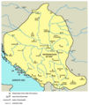
Banat is defined as the part of thePannonian Basinbordered by theDanubeto the south, theTiszato the west, theMureșto the north and theSouthern Carpathiansto the east.[9]The historical Banat totals an area of 28,526 km2.Various sources indicate figures slightly different from this.[10]When the province was divided in 1920, Romania was assigned an area of 18,966 km2(approximately ⅔ of the total), theKingdom of Serbs, Croats and Slovenes9,276 km2(approximately ⅓ of the total), and Hungary 284 km2(approximately 1% of the total).[11]
The Romanian Banat is mountainous in the south and southeast, while in the north, west and southwest it is flat and in some places marshy.[9]Some Banat mountain massifs constitute the western branch of the Southern Carpathians, i.e.,Țarcu Mountainsand Cerna Mountains. ThePoiana Ruscă MountainsandBanat Mountainswith the Semenic, Anina, Dognecea, Almăj and Locva divisions are part of theWestern Carpathians.The western pre-mountainous hills make up about a third of the historical Banat territory. Their altitude varies between 200 and 400 meters. The high plain (with altitudes of over 100 meters, up to 140 meters) is represented by the plains of Vinga, Buziaș, Gătaia and Fizeș. The plains with intermediate altitudes, between 100 and 130 meters, are the plains of Hodoni, Duboz, Tormac, Jamu Mare, Arad and Sânnicolau Mare, and the low plain (with altitudes below 100 meters) is represented by the river meadows, the floodplains before the extensive regularization works. These plains, components of the Pannonian Plain, represent another third of the Banat area. Worth mentioning are the twoextinct volcanoesfrom Lucareț and Gătaia: Piatra Roșie (211 m) and Șumigu (200 m), respectively.
The relief of Serbian Banat is monotonous, except for a few morphological units: theVršac Mountains,the Bela Crkva basin and the east Banat alluvium. The largest stretch of sand in Europe, today stabilized and covered with vegetation,Deliblatska Peščara,also lies in Serbian Banat.[12]
Climate[edit]
The climate of Banat is predominantly temperate (Cfb,according toKöppen classification), with a northeastward increase of continental and orographic effects (Dfb). Frequent cyclones from the Mediterranean cause positive precipitation anomalies especially in the western parts and, due to the maritime influence, winters are mild and short, but when northeastern conditions prevail, harshfrostsmay occur. Mean annual temperatures range between 12 °C (with average summer temperatures above 22 °C in July) and 6 °C towards the eastern highlands.[13]Besides, temperature inversions occur in the valleys and in the depressions of the Banat Hills, the bottom being colder than the slopes. The thermal and dynamic convection produced on the slopes causes greater cloudiness throughout the year; humidity and precipitation are higher.[14]
Hydrography[edit]

Considering the low and undesiccated land, there is a relatively large number of watercourses in Banat. The rivers bordering the area and delimiting it from the rest of the territories areMureș,TiszaandDanube.With the exception of some small local tributaries, the Mureș does not have a very large area. The other rivers that have their source in Banat are direct or indirect tributaries of the Tisza and the Danube.[14]The Danube forms betweenBaziașandPorțile de Fier,over a distance of 140 km, the so-calledIron Gates.Tisza is the river that separates the Banat from the Hungarian areas to the west and divides the currentVojvodinainto two parts. A wide river that meanders through the plain that bears its name.
TheTimiș/Tamišis the largest inland river of Banat, which has its sources on the eastern slopes of the Semenic Mountains, inCaraș-Severin County.The river is formed at the confluence of three branches: Semenic, Grădiște and Brebu. It crosses the entireTimiș County,then passes into Serbia, where it flows into the Danube, atPančevo.The most important cities through which Timiș passes areCaransebeș,LugojandPančevo.[15]
TheBega/Begejsprings from thePoiana Ruscă Mountains,crosses the area ofFăgetandLugoj,passes throughTimișoara,then descends through achannel,flowing into the Tisza, atTitel.[15]Bega andAranca/Zlaticaflow into the Tisza, and Timiș with its tributaries, such asPogăniș,Bârzava/Brzava,Caraș/KarašandNera,flow into the Danube.
There are no large naturallakes.In the past, there were many lakes, ponds and swamps in Banat, which were drained byland reclamationcarried out at the end of the 18th century and the beginning of the 19th century. There are bigger lakes only south ofZrenjanin.[16]
History[edit]
| History of Banat |
|---|
 |
| Historical Banat |
|
| Modern Romanian Banat |
| Modern Serbian Banat |
| Modern Hungarian Banat |
The first known inhabitants of present-day Banat were theNeolithicpopulations. In the 4th century BC,Celtic tribessettled in this area. VariousHallstattandLa Tèneobjects were found in this area. The most important tribes were theScordisciand theTaurisci.The Scordisci, who formed a powerful state even minted their own coins, imitating the Macedonian tetradrachm. TheScordiscisubdued as all the other tribes in the region to the getic rulerBurebista,therefore their region was part of theDaciankingdom underBurebistain the first century BC, but the balance of power in the area partially changed during the campaigns ofAugustus.At the beginning of the 2nd century AD,Trajanled two wars against the Dacians: the campaigns of 101–102, and 105–106. Eventually, the territory of Banat fell under Roman rule. It became an important link betweenDaciaprovince and the other parts of the Empire. Roman rule had a significant impact:castraand guard stations were established and roads and public buildings built. The public bath establishments of Ad Aquas Herculis, modern-dayBăile Herculanewere also established. Some of the important Roman settlements in Banat were:Arcidava(todayVărădia),Centum Putea,Berzobis (todayBerzovia), Tibiscum (todayJupa), Agnaviae (todayZăvoi), Ad Pannonios (todayTeregova), Praetorium (todayMehadia), and Dierna (todayOrșova).
In 273 AD EmperorAurelianwithdrew the Roman Army from Dacia. The area fell into the hands offoederatisuch as theSarmatians(Iazyges,Roxolani,Limigantes) and later theGoths,who also took control of other parts of Dacia.
-
 Ancient Indo-European peoples in Banat
 -
 Ancient Roman cities in Banat


Migration Period and Early Middle Ages[edit]

TheGothswere forced out by theHuns,who organized their ruling center in thePannonian Basin(thePannonian Plain), an area that included the northwestern part of today's Banat. After the death ofAttila,the Hunnic empire disintegrated in days. The previously subjectedGepidsformed a new kingdom in the area, only to be defeated 100 years later by theAvars.
One governing center of the Avars was formed in the region, which played an important role in the Avar–Byzantine wars. An inscription on one of the vessels from theTreasure of Sânnicolau Mare(which origin is disputed) recorded names of two local rulers,ButaulandBuyla,who boreSlavicruling titles ofžupan.The Avar rule over the area lasted until the 9th century, untilCharlemagne's campaigns. Banat region became part of theFirst Bulgarian Empirea few decades later. Archaeological evidence shows the Avars and Gepids lived here until the middle of the 10th century. The Avar rule had triggered considerableSlavicmigration to the southern Pannonian plain and to the Balkans.
In 895, theHungariansliving inEtelközentered the Byzantine-Bulgarian war as allies of Byzantium, and defeated the Bulgars. Because of this, the Bulgarians allied with thePechenegs,who attacked the Hungarian settlements. This led to the process of what is known as the Hungarian conquest of the Pannonian basin, referred to by them as "hometaking" (honfoglalás) in Hungarian. This also resulted in the loss of part of the territories north of the Danube for the Bulgarian Empire.
According toGesta Hungarorumchronicle, a local ruler known as Glad ruled over Banat and his army was formed by Vlachs, Bulgarians, and Cumans.[17]Ahtum was another early-11th-century ruler in the territory now known as Banat. His primary source is the Long Life of Saint Gerard, a 14th-century hagiography. Chanadinus, Ahtum's former commander-in-chief, defeated and killed Ahtum, occupying his realm.[17]
Hungarian administration (11th–16th centuries)[edit]

Banat was administered by theFirst Bulgarian Empirefrom the 9th to the 11th century, but that control gradually migrated to the Kingdom of Hungary which administered it from the 11th century up until 1552, when the region ofTemesvár(today Timișoara) was captured by theOttoman Empire.
The area of the Timiș river was not the land of the Hungarian royal tribe. When nomadic Hungarians came to Transylvania there was no direct Bulgarian political rule there.[18]In the eastern part of theCarpathian basintheByzantine ritebecame more influential after Ajtony's (Latin:Ahtum) conversion to Christianity. This was halted with the establishment of theKingdom of Hungary.István Ireasserted dominance over the last local leader, Ajtony. He was a semi-independent ruler of Banat and a formally baptized Christian who constructed a Byzantine monastery at Morisena, but still kept 7 wives and worshiped Pagan gods at his Court. His vassalCsanáddefeated him by the will of King Stephen I of Hungary. The territory of the modern Banat did not form a separate territorial unit in medievalKingdom of Hungary,it was an integral part of it. The territory was shared byKrassó,Keve,Temes,Csanád,AradandTorontál counties.
In 1233, under the Kingdom of Hungary administration, theBanate of Severin,a military frontier area was formed, including some eastern parts of the modern Banat. In the 14th century, the region became of priority concern to the Kingdom, as the southern border of Banat was the most important defensive line againstOttomanexpansion from the southeast.
-
 Duchy ofGlad,9th century
 -
 Duchy ofAhtum,11th century
 -
 Counties of the Kingdom of Hungary in present-day Banat in the 14th century
 -
 Banate of Severin


Ottoman administration (1552–1716)[edit]

TheOttoman Empiretook over the area and incorporated Banat in 1552. It was absorbed as an Ottomaneyalet(province) named theEyalet of Temeşvar.The Banat region was mainly populated byRascians(Serbs) in the west,[19]andVlachs(Romanians) in the east. Thus, in some historical sources, the region of Banat was referred to asRascia,while in others asWallachia.[19]Numerous Ottoman Muslims settled in the area, living mostly in the cities and associated with trade and administration.
Not all of Banat fell immediately under Turkish rule. Eastern regions aroundLugojandCaransebeșcame under the rule of Princes of Transylvania. In that area, a new banate was formed, known as theBanate of Lugoj and Caransebeș.
In the spring of 1594, shortly after the beginning of theAustro-Turkish War (1593-1606),local Serbian Christians,[20][21]in theEyalet of Temeşvar,started anuprisingagainst Turkish rule. The local Romanians also participated in this uprising. At first, rebels were successful. They took the city ofVršacand various other towns in Banat and started negotiations with Prince of Transylvania. One of the leaders of the uprising was local Serbian Orthodox BishopTheodore.[22]
In the middle of the 17th century, the territory ofBanate of Lugoj and Caransebeșfinally fell under Turkish rule and was incorporated intoEyalet of Temeşvar.
DuringAustro-Turkish War (1683–1699),local Serbian uprisings broke out in various parts ofEyalet of Temeşvar.Austrian armies and Serbian militia tried to drive out sultans army from the province, but Turks succeeded in holding the fort of Temesvár. In 1689, Serbian patriarchArsenije IIIsided with Austrians. His jurisdiction (including the province) was officially recognized by the charters of emperorLeopold Iin 1690, 1691 and 1695. Under theTreaty of Karlowitz(1699), northern parts of theEyalet of Temeşvarwere incorporated into theHabsburg monarchy,but the territory of Banat remained under Turkish rule.
-
 Jurisdiction ofSerbian Patriarchatein the 16th and 17th centuries
 -
-
 Uprising in Banatin 1594
 -
 Eyalet of Temeşvarin the mid-17th century
 -
 Eyalet of Temeşvarand the surrounding regions in 1683
 -
 Eyalet of Temeşvar,from 1699 to 1716


Habsburg administration (1716–1867)[edit]


At the beginning of the nextAustro-Turkish War (1716–1718),Prince Eugene of Savoytook the Banat region from theTurks.After theTreaty of Passarowitz(1718), the region became a province of the Habsburg Monarchy. It was not incorporated into the Kingdom of Hungary. Special provincial administration was established, centered in Temesvár.
In 1738, over 50 Romanian villages from Serbia and Banat were destroyed and dwellers murdered by Austrians and Serb militia during a revolt of Romanians.[23]Also governor of the province was not given the title of "ban", the region became known as theBanate of Temesor Banat of Temeswar. It remained a separate province within the Habsburg monarchy and under military administration until 1751, when EmpressMaria Theresa of Austriareorganized the province, dividing it between military and civil administration. The Banat of Temeswar province was abolished in 1778, when civilian part of the region was incorporated into the Kingdom of Hungary and divided into counties. The southern part of the Banat region remained within theMilitary Frontier(Banat Krajina) until the Frontier was abolished in 1871.
During the Ottoman rule, parts of Banat had a low population density due to years of warfare, and some local residents also died during Habsburg-Ottoman wars and Prince Eugene of Savoy's conquest. Much of the area had reverted to nearly uninhabited marsh, heath and forest. CountClaudius Mercy(1666–1734), who was appointed governor of the Banat of Temeswar in 1720, took numerous measures for the regeneration of Banat. He recruited German artisans and especially farmers from Bavaria and other southern areas as colonists, allowing them privileges such as keeping their language and religion in their settlements. Farmers brought their families and belongings on rafts down theDanube River,and were encouraged to restore farming in the area. They cleared the marshes near theDanubeandTisarivers, helped build roads and canals, and re-established agriculture. Trade was also encouraged.[24]
Maria Theresaalso took a direct interest in Banat; she colonized the region with large numbers ofGermanfarmers, who were admired for their agricultural skills. She encouraged the exploitation of the mineral wealth of the country, and generally developed the measures that were introduced by Count Mercy.[24]German settlers arrived fromSwabia,AlsaceandBavaria,as did German-speaking colonists from Austria. Many settlements in the eastern Banat were developed by Germans and had ethnic-German majorities. The ethnic Germans in the Banat region became known as theDanube Swabians,orDonauschwaben.After years of separation from their original German provinces, their language was markedly different, preserving historic characteristics.
Similarly, a minority coming from French-speaking or linguistically mixed communes inLorrainemaintained the French language for several generations, and developed a specific ethnic identity, later known as Banat French,Français du Banat.[25]
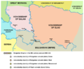
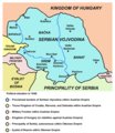
In 1779, the Banat region was incorporated into theHabsburg Kingdom of Hungary,and the three counties ofTorontal,TemesandKaraschwere created. In 1848, after theMay Assembly,the western Banat became part of theSerbian Vojvodina,a Serbian autonomous region within the Habsburg Monarchy. During theRevolutions of 1848–1849,Banat was respectively held bySerbianandHungariantroops.
After the Revolution of 1848–1849, Banat (together withSyrmiaandBačka) was designated as a separateAustriancrownland known as theVoivodeship of Serbia and Temes Banat.In 1860 this province was abolished and most of its territory was incorporated into the Habsburg Kingdom of Hungary.
The Serbian Banat (Western Banat) was part ofSerbian Vojvodina(1848–1849) and part of theVoivodeship of Serbia and Temes Banat(1849–1860). After 1860, later Serbian Banat was part ofTorontaland Temes counties ofHabsburg Kingdom of Hungary.The center of Torontal county was Großbetschkerek (Hungarian: Nagybecskerek, Serbian: Veliki Bečkerek), the currentZrenjanin.
Hungarian administration (1867–1918)[edit]
In 1867, after the Austro-Hungarian compromise the territory returned again to Hungarian administration. After 1871, the formerMilitary Frontier,located in southern parts of Banat, came under civil administration and was incorporated into Banat's counties.KrassóandSzörénywere united intoKrassó-Szörényin 1881.
-
 Proclaimed borders ofSerbian Vojvodinain 1848 (including Western Banat)
 -
 Voivodeship of Serbia and Temes Banat(1849–1860)
 -
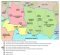


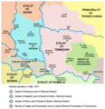
The Banat Question at the end of First World War[edit]
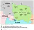
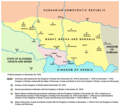
In 1918, theBanat Republicwas proclaimed in Timișoara in October, and the government of Hungary recognized its independence. However, it was short-lived. After just two weeks,Serbiantroopsinvaded the region and took control.From November 1918 to March 1919, western and central parts of Banat were governed by Serbian administration fromNovi Sad,as part of theBanat, Bačka and Baranjaprovince of the Kingdom of Serbia and newly formed Kingdom of Serbs, Croats and Slovenes (which was later renamed asYugoslavia).
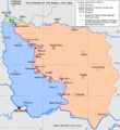
In the wake of the Declaration ofUnion of Transylvania with Romaniaon December 1, 1918, and the Declaration of Unification of Banat, Bačka and Baranja with Serbia on November 25, 1918, most of Banat was (on July 26, 1919) divided between Romania (Krassó-Szörénycompletely, two-thirds of Temes, and a small part ofTorontál) and theKingdom of Serbs, Croats and Slovenes(most ofTorontál,and one-third of Temes). A small area nearSzegedwas assigned to the newly independent Hungary. These borders were confirmed by the 1919Treaty of Versaillesand the 1920Treaty of Trianon.
At the dissolution ofAustria-Hungary,the delegates of the Romanian and some German communities voted for union with Romania during theGreat National Assembly of Alba Iulia;[26]the delegates of the Serbian, Bunjevac and other Slavic and non-Slavic communities (including some Germans) voted for union with Serbia during theGreat People's Assembly of Serbs, Bunjevci and other Slavs in Banat, Bačka and Baranja;[citation needed]while the Hungarian minority remained loyal to the government in Budapest. Besides these declarations, no other plebiscite was held.
-
 Self-proclaimedBanat Republicin 1918
 -
 Situation around Banat in 1918
 -
 Situation around Banat in 1919–1921
 -
 Division of Banat in 1919–1923


Romanian Banat since the First World War[edit]


In 1938, the counties ofTimiș-Torontal,Caraș,Severin,AradandHunedoarawere joined to formținutul Timiș,which roughly encompassed the area typically called Banat in Romania.
On 6 September 1950, the province was replaced by theTimișoara Region(formed by the present-day counties of Timiș andCaraș-Severin). In 1956, the southern half of the existing Arad Region was incorporated to the Timișoara Region. In December 1960, the Timișoara Region was renamed the Banat Region.
On 17 February 1968, a new territorial division was made and today's Timiș,Caraș-SeverinandAradcounties were formed.
Since 1998, Romania has been divided into eightdevelopment regions,acting as divisions that coordinate and implement regional development. TheVest development regionis composed of four counties: Arad, Timiș, Hunedoara and Caraș-Severin; thus it has almost same borders as the Timiș Province (ținutul Timiș) of 1938. The Vest development region is also a part of theDanube-Criș-Mureș-TisaEuroregion.
Serbian Banat since the First World War[edit]


The region was claimed by theKingdom of Serbs, Croats and Slovenesbetween 1918 and 1922 (as the province ofBanat, Bačka and Baranjabetween 1918 and 1919) and from 1922 to 1929 it was divided between Belgrade oblast andPodunavljeoblast. In 1929, most of the region was incorporated into theDanube Banovina(Danubian Banat), a province of theKingdom of Yugoslavia,while the city ofPančevowas incorporated into self-governed Belgrade district.
During World War II, the Axis Powers occupied this area and partitioned it. Nazi Germany had been intent on expanding into eastern Europe to incorporate what it called theVolksdeutsche,people of ethnic German descent. They established the political entity known as Banat in 1941. It included only the western part of the historical Banat region, which was formerly part of Yugoslavia. It was formally under the control of the Serbian puppet Government of National Salvation in Belgrade led byMilan Nedić.It theoretically had limited jurisdiction over all of the territory under German Military Administration in Serbia, but in practice the local minority of ethnic Germans (Danube SwabiansorShwoveh) held the political power within Banat. The regional civilian commissioner was Josef Lapp. The head of the ethnic German group wasSepp Janko.Following the ousting of Axis forces in 1944, this German-ruled region was dissolved. As a consequence, much of the local Germans fled from the region together with defeated German army in 1944. Most of its territory was included in the Vojvodina, one of the two autonomous provinces of Serbia within the new SFR Yugoslavia. Following WWII, mostethnic Germans were expelledfrom Banat and eastern Europe. Those Germans who remained in the country were sent to prison camps run by the new communist authorities. After prison camps were dissolved (in 1948), most of the remaining German population left Serbia because of economic reasons. Many went to Germany; others emigrated to western Europe and the United States.
Since 1944–1945, the Serbian Banat (together with Bačka andSyrmia), has been part of theSerbianAutonomous Province of Vojvodina,first as part of theSocialist Federal Republic of Yugoslaviaand then as part of theFederal Republic of YugoslaviaandSerbia and Montenegro.Since 2006, it has been part of an independent Serbia.
Hungarian Banat since the First World War[edit]
The Hungarian Banat consists of a small northern part of the region, which is part of theCsongrád-Csanád Countyof Hungary and is made up of seven villages and the district ofSzeged,Újszeged. The Hungarian part of Banat used to be the northernmost region of theTorontál Countyin theKingdom of Hungary.
Administrative organization[edit]
In Romania, Banat includes all ofTimișandCaraș-Severincounties (with the exception ofBăuțar),Arad County(only the part south of theMureș), theMehedințipanhandle(several localities from the traditional Banat area disappeared under the waters of thePorțile de Fier reservoir) andHunedoara County(only the villages ofPojogaandSălciva).[8]
The Serbian Banat includes the part located east of theTiszainVojvodina:North Banat District,Central Banat DistrictandSouth Banat District,as well as a part ofCentral Serbia(the area calledPančevački Rit,forming the left part of theDanubein themunicipality of Palilula,included in theBelgrade metropolitan area).[8]
In Hungary, there is only a small part ofCsongrád-Csanád County,namely the part located in the southern angle formed by the Tisza and Mureș rivers, up to the state border with Romania and Serbia.[8]
Largest cities[edit]
The following table lists the cities in Banat with a population greater than 10,000 (2022).[27][28]Some cities that are not historically part of Banat expanded into this region during the 20th century, so that today some districts lie in the historical Banat:Arad(Aradu Nou),Belgrade(Palilula) andSzeged(Újszeged).

|
| Timișoara |

|
| Pančevo |

|
| Zrenjanin |

|
| Reșița |

|
| Lugoj |

|
| Kikinda |
| City | Population | Country | Administrative | Historic subregion | ||
|---|---|---|---|---|---|---|
| 1 | Timișoara | 250,849 | Timiș County | Romanian Banat | ||
| 2 | Pančevo(Панчево) | 73,401 | South Banat District | Serbian Banat | ||
| 3 | Zrenjanin(Зрењанин) | 67,129 | Central Banat District | Serbian Banat | ||
| 4 | Reșița | 55,181 | Caraș-Severin County | Romanian Banat | ||
| 5 | Lugoj | 34,462 | Timiș County | Romanian Banat | ||
| 6 | Kikinda(Кикинда) | 32,084 | North Banat District | Serbian Banat | ||
| 7 | Vršac(Вршац) | 31,946 | South Banat District | Serbian Banat | ||
| 8 | Caransebeș | 21,133 | Caraș-Severin County | Romanian Banat | ||
| 9 | Dumbrăvița | 20,014 | Timiș County | Romanian Banat | ||
| 10 | Giroc | 17,999 | Timiș County | Romanian Banat | ||
| 11 | Bocșa | 12,949 | Caraș-Severin County | Romanian Banat | ||
| 12 | Kovin(Ковин) | 11,623 | South Banat District | Serbian Banat | ||
| 13 | Novi Bečej(Нови Бечеј) | 10,967 | Central Banat District | Serbian Banat | ||
| 14 | Sânnicolau Mare | 10,627 | Timiș County | Romanian Banat | ||
| 15 | Jimbolia | 10,179 | Timiș County | Romanian Banat | ||
| 16 | Lipova | 10,040 | Arad County | Romanian Banat |
Demographics[edit]
| Year | Total | Romanians | Serbs | Hungarians | Germans | Others |
|---|---|---|---|---|---|---|
| Romanian Banat[29] | ||||||
| 1910 | 984,849 | 515,485 (52.3%) | 48,733 (4.9%) | 120,959 (12.3%) | 252,802 (25.7%) | 46,870 (4.8%) |
| 1931 | 961,808 | 532,589 (55.3%) | 36,491 (3.8%) | 97,854 (10.2%) | 246,354 (25.6%) | 48,520 (5.1%) |
| 1956 | 972,490 | 648,925 (66.7%) | 31,156 (3.2%) | 86,592 (8.9%) | 147,275 (15.1%) | 58,542 (6.1%) |
| 1992 | 1,142,710 | 954,846 (83.5%) | 15,622 (1.4%) | 67,497 (5.9%) | 30,843 (2.7%) | 73,902 (6.5%) |
| 2002 | 1,078,190 | 916,492 (85.1%) | 20,937 (1.9%) | 59,691 (5.5%) | 21,083 (1.9%) | 59,987 (5.6%) |
| Serbian Banat[29] | ||||||
| 1910 | 580,957 | 76,398 (13.1%) | 232,009 (40.0%) | 109,510 (18.8%) | 133,495 (23.0%) | 29,175 (5.1%) |
| 1931 | 586,906 | 61,743 (10.5%) | 271,900 (46.3%) | 90,670 (15.4%) | 116,900 (20.0%) | 45,693 (7.8%) |
| 1953 | 631,485 | 55,439 (8.8%) | 388,268 (61.5%) | 110,030 (17.4%) | 6,277 (1.0%) | 69,911 (11.3%) |
| 1992 | 690,314 | 33,795 (4.9%) | 460,929 (66.7%) | 72,508 (10.5%) | — | 124,072 (17.9%) |
| 2022 | 540,041 | 21,082 (3.90%) | 453,612 (83.99%) | 101,857 (18.86%) | 854 (0.1%) | 74,059 (12.4%) |
| Hungarian Banat[29] | ||||||
| 1910 | 16,758 | 85 (0.5%) | 3,588 (21.4%) | 11,683 (69.7%) | 1,248 (7.5%) | 154 (0.9%) |
| 1930 | 18,483 | — | 471 (2.5%) | 16,967 (91.9%) | 1,045 (5.6%) | — |
| 1949 | 19,334 | — | — | 19,024 (98.4%) | — | 310 (1.6%) |
| 1990 | 18,601 | — | — | 18,601 (100%) | — | — |
| 2001 | 20,139 | — | — | 20,139 (100%) | — | — |
Romanian Banat[edit]
Romaniansform a majority in the south, center and east of Banat. Their share increased, after 1930, also in the Timiș Plain (where they were a minority) through immigration fromTransylvania,MoldaviaandOltenia.[30]In some settlements the majority is made up of other peoples:Serbsmake up the absolute majority inPojejena(Пожежена) andSvinița(Свињица), and the relative majority inSocol(Соколовац);Croats(Krašovani) make up the majority inCarașova(Karaševo) andLupac(Lupak);Bulgariansmake up the majority inDudeștii Vechi(Stár Bišnov); whileUkrainiansmake up the majority inȘtiuca(Щука) andCopăcele(Копашиль).[31]
Serbian Banat[edit]
In most cities and municipalities of the Serbian Banat, the majority population is Serbian.Hungariansmake up the majority of the population inČoka(Csóka), andSlovaksmake up the relative majority in the ethnically mixed municipality ofKovačica.Romanians make up the majority in certain settlements, andCzechsinČeško Selo.
Hungarian Banat[edit]
In the Hungarian part of Banat, the majority population is Hungarian, but in some villages in the region (Deszk/Деска,Szőreg/Сириг,Újszentiván/Нови Сентиван) there is also a Serbian minority.
Symbols[edit]
The traditional heraldic symbol of Banat is alion,which is nowadays present in both thecoat of arms of Romaniaand thecoat of arms of Vojvodina.It is assumed that the Banat lion has its origin in the Cuman lion.[32]
The current coat of arms of the Romanian Banat was designed in 1921, after the union of the Banat with theKingdom of Romania,by the heraldistJózsef Sebestyénby combining some elements from the coats of arms ofTemesandKrassócounties from 1779 to represent the "Romanian Banat of Severin".[32]It consists of a redshieldin which is represented a goldenlion rampantemerging from a golden bridge with two arched openings, built of carved stone, over an azure river. According to its author, "the lion is the old (Cuman) element, the bridge is the new element,Trajan's Bridgeover theDanube".[32]The coat of arms from 1921 was modified in 1992 by adding asabrein the right paw,[33]recalling thebackswordofPál Kinizsi,count of Temes.
Serbs use the seal of theVelika Kikinda Districtof 1774 to represent Banat.[32]It also features a golden lion rampant with a sabre in the right paw and a severed Turkish head in the left one.
Notable people[edit]
- Radomir Antić(1948–2020), football player and coach
- Mihajlo Idvorski Pupin(1858–1935), Serbian physicist, physical chemist and philanthropist
- Iolanda Balaș(1936–2016), high jumper
- Béla Bartók(1881–1945), composer, pianist and ethnomusicologist
- Miodrag Belodedici(b. 1964), football player and coach
- Dejan Bodiroga(b. 1973), basketball player
- Nicu Covaci(b. 1947), singer
- Sava II Branković,Orthodox priest and Saint
- Vuk Drašković(b. 1946), writer and politician
- Nicolae Kovács(b. 1911), fotballer
- Nikola Grbić(b. 1973), volleyball player and coach
- Vladimir Grbić(b. 1970), volleyball player
- Arnold Hauser(1892–1978), art historian and sociologist
- Aleksa Janković(1806-1869), Prime Minister of Serbia, born inTimișoara
- Ion Ivanovici(1845–1902), military band conductor and composer
- Francesco Illy(1892–1956), inventor of coffee machine and businessman
- Đura Jakšić(1832–1878), painter, poet, storyteller and playwright
- Károly Kerényi(1897–1973), philologist and father of Greek mythology studies
- Ștefan Kovács(1920–1995), football player and coach
- Nikolaus Lenau(1802–1850), poet
- Bela Lugosi(1882–1956), actor
- Herta Müller(b. 1953), novelist, poet and essayist
- Dorinel Munteanu(b. 1968), football player and coach
- Dositej Obradović(1742-1811), writer
- Ana Pacatiuș(born 1939), folksinger
- Vasko Popa(1922–1991), poet
- Julieta Szönyi(b. 1949), actor
- Ștefan Szönyi(1913–1967) (hu;ro) painter
- Döme Sztójay(1883–1946), soldier and diplomat
- Zoran Tošić(b. 1987), football player
- Traian Vuia(1872–1950), inventor and aviation pioneer
- Zvonimir Vukić(b. 1979), football player
- Ivana Vuleta(b. 1990), long jumper
- Johnny Weissmuller(1904–1984), swimmer, water polo player and actor
References[edit]
Citations[edit]
- ^"Banat".Merriam-Webster Dictionary.
- ^"Banat".Collins English Dictionary/Webster's New World College Dictionary.
- ^abcdDocea, Vasile (2007). "A la recherche du Banat disparu". In Babeți, Adriana (ed.).Le Banat: un Eldorado aux confins(PDF).Cultures d'Europe centrale – Hors série № 4. Université Paris-Sorbonne (Paris IV): Centre Interdisciplinaire de Recherches Centre-Européennes. pp. 53–63.
- ^"Banat".Encyclopedia Britannica.
- ^Pohl, Walter (1988).Die Awaren: ein Steppenvolk im Mitteleuropa, 567-822 n. Chr.Munich: C. H. Beck.ISBN9783406333309.OCLC19845725.
- ^abTemesköz.
{{cite book}}:|work=ignored (help) - ^Pálffy, Géza (2001)."The Impact of the Ottoman Rule on Hungary"(PDF).Hungarian Studies Review.28(1–2): 109–132.
- ^abcdBoth, Ștefan (3 February 2013)."Banatul, un veritabil Eldorado al Europei. Etimologia numelui regiunii".Adevărul.
- ^abRusu, Raularian (2007).Organizarea spațiului geografic în Banat(PDF).Timișoara: Mirton.ISBN978-973-52-0201-9.Archived fromthe original(PDF)on 2023-03-27.Retrieved2022-12-12.
- ^Forțiu, Sorin."Și totuși, care este suprafața Banatului?"(PDF).
- ^Bizerea, Marius (1975). "Banatul, ca unitate și individualitate istorico-geografică în cadrul pământului locuit de români".Tibiscus.Etnografie. Timișoara: Muzeul Banatului: 7–25.
- ^Marković, Jovan Đ.; Pavlović, Mila A. (1995).Географске регије Југославије (Србија и Црна Гора).Belgrade: Savremena administracija.
- ^Gumnior, Maren; Stobbe, Astrid (2021)."First palynological results from lowland sites in the Romanian Banat and their implications for settlement and land use dynamics in the southeastern Carpathian Basin".Quaternary International.583:48–61.Bibcode:2021QuInt.583...48G.doi:10.1016/j.quaint.2021.02.005.S2CID233887936.
- ^abHațegan, Ioan; Savulov, Lucia (1997)."Banatul medieval"(PDF).Analele Banatului.5:179–216.
- ^abSilaghi, Vali (13 April 2013)."Râurile înfrățite din Banat: cum și-a căpătat Bega numele".Adevărul.
- ^Marković, Jovan Đ. (1966).Географске области Социјалистичке Федеративне Републике Југославије.Belgrade: Zavod za izdavanje udžbenika Socijalističke Republike Srbije.
- ^abMadgearu, Alexandru (1998). "Geneza și evoluția voievodatului bănățean din secolul al X-lea".Studii și materiale de istorie medie.16:191–207.
- ^Spinei, Victor (2009).The Romanians and the Turkic Nomads North of the Danube Delta from the Tenth to the Mid-Thirteenth Century.East Central and Eastern Europe in the Middle Ages, 450-1450. Vol. 6. Brill. p. 59.ISBN978-90-47-42880-0.
- ^abPálffy 2021,p. 85.
- ^Gavrilović 1993,p. 44.
- ^Lemajić 2015,pp. 218–221.
- ^Ćirković 2004,pp. 141–142.
- ^Picot, Émile (1873).Les Serbes de Hongrie, leur histoire, leurs priviléges, leur église, leur état politique et social(PDF).Prague: Grégr & Dattel. p. 113.
- ^abChisholm, Hugh,ed. (1911)..Encyclopædia Britannica(11th ed.). Cambridge University Press.
- ^Vultur, Smaranda (2021). "De l'Ouest à l'Est et de l'Est à l'Ouest: les avatars identitaires des Français du Banat".Des mémoires et des vies: le périple identitaire des Français du Banat.Avignon: Éditions Universitaires d'Avignon. pp. 25–51.doi:10.4000/books.eua.5770.ISBN9782357681323.S2CID248974401.
- ^"The Resolution of the National Assembly in Alba-Iulia on the 18th of November/the 1st of December".Institutul Național al Patrimoniului.
- ^"Romania: Counties and Major Cities".City Population.
- ^"Serbia: Regions, Districts and Major Cities".City Population.
- ^abcKókai, Sándor (2020)."How the Trianon Peace Treaty impeded social and spatial structure progress in the Bánság (1918–2010)"(PDF).Regional Statistics.10(1): 133–150.doi:10.15196/RS100108.S2CID251603657.
- ^Berceanu, Iancu Constantin (2019)."Aspecte geografice ale evoluției structurii etnice a populației Banatului".Morisena.1(13): 53–56.ISSN2501-1359.
- ^Crețan, Remus; Turnock, David; Woudstra, Jaco (2008)."Identity and multiculturalism in the Romanian Banat".Méditerranée.110(110): 17–26.doi:10.4000/mediterranee.523.ISSN0025-8296.
- ^abcdBasarabă, Drăgan-George (2017)."Despre stema Banatului. Certitudini și supoziții heraldice".Acta Terrae Fogarasiensis.6:157–174.ISSN2285-5130.
- ^"Lege nr. 102 din 21 septembrie 1992".Portal Legislativ.
Sources[edit]
- Bataković, Dušan T., ed. (2005).Histoire du peuple serbe.Lausanne: L'Âge d'Homme.ISBN9782825119587.
- Bocșan, Nicolae (2015)."Illyrian privileges and the Romanians from the Banat"(PDF).Banatica.25:243–258.
- Ćirković, Sima M. (2004).The Serbs.Blackwell Publishing.ISBN0-631-20471-7.
- Engel, Pál (2001).The Realm of St Stephen: A History of Medieval Hungary, 895-1526.London: I.B. Tauris.ISBN9781417540808.OCLC56676014.
- Förster, Horst; Wolf, Josef (2004).Entwicklung der ethnischen Struktur des Banats 1890 - 1992.Borntraeger.ISBN978-3-443-28519-7.
- Fodor, Pál; Dávid, Géza, eds. (2000).Ottomans, Hungarians, and Habsburgs in Central Europe: The Military Confines in the Era of Ottoman Conquest.Brill.ISBN90-04-11907-8.ISSN1380-6076.
- Gavrilović, Slavko (1993)."Serbs in Hungary, Slavonia and Croatia in struggles against the Turks (15th-18th centuries)".In Samardžić, Radovan; Duškov, Milan (eds.).Serbs in European Civilization.NOVA. pp. 41–54.ISBN86-7583-015-7.
- Ilić-Mandić, Jelena (2020)."The Local Elite in Central Government Service: Banat Military Frontier Officers in the 18th Century".The Habsburg State-wide and the regions in the Southern Danube basin (16th-20th centuries).Wien: New academic press. pp. 99–121.
- Ilić-Mandić, Jelena (2021)."Forging the Wallachian Military Border, 1769-1772"(PDF).Banatica.31(2): 251–273.
- Ilić-Mandić, Jelena (2022a)."Making the Border and Frontiersmen: Militarisation in Temeswarer Banat, 1764-1775".In Magina, Livia; Fodor, Gelu; Cîmpeanu, Liviu; Ardelean, Florin Nicolae (eds.).From medieval frontiers to early modern borders in Central and South-Eastern Europe.Berlin: Peter Lang Publishing. pp. 207–228.doi:10.3726/b19870.ISBN978-3-631-88012-8.S2CID249809935.
- Ilić-Mandić, Jelena (2022b)."The Military Frontier and Emigration Challenges in the 18th Century"(PDF).Migrations in the Slavic Cultural Space From the Middle Ages to the Present Day.Lódź: Wydawnictwo Universytetu Lódzkiego. pp. 45–62.
- Ingrao, Charles; Samardžić, Nikola; Pešalj, Jovan, eds. (2011).The Peace of Passarowitz, 1718.West Lafayette, Indiana: Purdue University Press.ISBN978-1-55753-594-8.
- Isailović, Neven (2016)."Living by the Border: South Slavic Marcher Lords in the Late Medieval Balkans (13th–15th Centuries)".Banatica.26:105–117.ISSN1222-0612.
- Ivanović, Miloš; Isailović, Neven (2015)."The Danube in Serbian-Hungarian Relations in the 14th and 15th Centuries".Tibiscum.5:377–394.
- Ivić, Pavle, ed. (1995).The History of Serbian Culture.Porthill Publishers.ISBN9781870732314.
- Krstić, Aleksandar; Isailović, Neven (2015)."Serbian Language and Cyrillic Script as a Means of Diplomatic Literacy in South Eastern Europe in 15th and 16th Centuries".Yearbook of "George Barițiu" Institute of History(54). Cluj-Napoca: 185–195.ISSN1584-4390.
- Krstić, Aleksandar (2019). "Familiares of the Serbian despots in and from the territory of Banat (1411–1458)". In Zoltan, Iustin (ed.).Politics and Society in the Central and South-Eastern Europe (13th-16th centuries).Cluj-Napoca: Mega. pp. 93–109.
- Lemajić, Nenad (2015). "The Serbian Population of the Banat and the Western Mureș Basin in the 15th and 16th Centuries (and its Local and Military Leaders)". In Đura, Hardi; et al. (eds.).The Cultural and Historical Heritage of Vojvodina in the Context of Classical and Medieval Studies.Novi Sad: Faculty of Philosophy. pp. 205–222.ISBN9788660652968.OCLC1128942908.
- Mitrović, Andrej (1969).Jugoslavija na konferenciji mira 1919-1920.Zavod za izdavanje udžbenika Socijalističke Republike Srbije.
- Mitrović, Andrej (1975).Razganičenje Jugoslavije sa Madarskom i Rumunijom 1919-1920: prilog proučavanju jugoslavenske politike na konferenciji mira u Parizu.Institut za izučavanje istorije Vojvodine.
- Pálffy, Géza (2021).Hungary Between Two Empires 1526–1711.Bloomington: Indiana University Press.ISBN978-0-253-05464-7.
- Pešalj, Jovan (2010). "Early 18th-Century Peacekeeping: How Habsburgs and Ottomans Resolved Several Border Disputes after Karlowitz". In Mitev, Plamen; et al. (eds.).Empires and Peninsulas: Southeastern Europe between Karlowitz and the Peace of Adrianople, 1699–1829.Berlin: LIT. pp. 29–42.ISBN978-3-643-10611-7.
- Schatteles, Tiberiu (2013).Evreii din Timișoara în perspectivă istorică.Hasefer.ISBN9789736302671.
| Banat |
|
|---|---|
| Dobruja |
|
| Moldavia |
|
| Transylvania | |
| Wallachia | |
| |

| West-Hungarian Borderland |  | |
|---|---|---|
| Little Hungarian Plain | ||
| Transdanubia | ||
| Transdanubian Mountains | ||
| Transdanubian Hills | ||
| North Hungarian Mountains | ||
| Great Hungarian Plain | ||
| International | |
|---|---|
| National | |
| Other | |