Rossøya


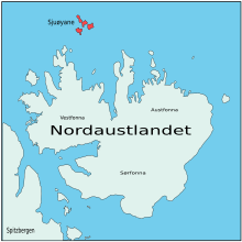
Rossøya,sometimes referred to asRoss Islandin English, is an island located in theArctic Ocean.It is a part ofSjuøyane,a group of islands in theSvalbardarchipelago, some 20 km north of the coast ofNordaustlandet,SvalbardinArctic Norway.Rossøya is located 100 m north-northwest of the somewhat larger islandVesle Tavleøya.The northern point of Rossøya, at 80° 49′ 44.41″ North, is the northernmost point in Svalbard, and thereby also in the Kingdom ofNorway.[1]The distance to theNorth Poleis 1024.3 kilometers (637 mi / 553 nm), toNordkappon the Norwegian mainland 1084 km and toPysen,off the southern tip of mainland Norway, 2580 km.
Some sources describe Rossøya as the northernmost point of Europe, but this requires thatFranz Josef Landbe considered part of Asia, sinceCape FligelyonRudolf Island,Russia,is located at 81° 48′ 24″ North, which is 109 km closer to the North Pole.
The island is named afterJames Clark Ross(1800–1862), aBritishexplorerwho was part ofWilliam Edward Parry's 1827 expedition withHMSHeclato reach theNorth Pole.After passing by Sjuøyane and Rossøya, the expedition was forced to give up, after getting stuck in the ice. However, the expedition set a new record as the expedition that had reached the furthest north at the time.[2]The island may have been sighted as early as 1618, along with the rest of Sjuøyane, by an Enkhuizen whaler. However, the island was marked on a map as early as 1663 byHendrick Doncker.This was later followed by cartographers such asPieter Goos,Cornelis GilesandOutger Rep.[3]The island was included in theNordaust-Svalbard Nature Reservesince 1 January 1973.
Accessibility by ship can be difficult due to ice conditions, but the island is more affected by theGulf Streamthan more southeasterly parts of Svalbard. The island is slightly greenish, due to the plantCochleraria groenlandica,that thrives due to the natural fertilizing from the birds' excrements. The most common bird is thelittle auk,though other common species include theAtlantic puffinandBrünnich's guillemot.Birds arrive in April–May, and stay during the summer. The only mammal is thepolar bear,which is most commonly found during the winter, when it can use the ice to cross to the island.[4]
References
[edit]- ^Norwegian Polar Institute."Rossøya".Retrieved2016-04-16.
- ^Prestvold, Kristin."Phipps' og Parry's expeditions".Norwegian Polar Institute.Retrieved4 June2009.
- ^Conway, W. M. (1906).No Man’s Land: A History of Spitsbergen from Its Discovery in 1596 to the Beginning of the Scientific Exploration of the Country.Cambridge: Cambridge University Press.
- ^Norwegian Polar Institute."Sjuøyane".Retrieved4 June2009.
Related Links
[edit]80°49.5′N20°20.5′E/ 80.8250°N 20.3417°E
