
Rumkale
| Rumkale | |
|---|---|
| Rumkale,Gaziantep,Turkey | |
 The Rumkale Fortress | |
 Rumkale | |
| Coordinates | 37°16′19″N37°50′17″E/ 37.27194°N 37.83806°E |
| Type | Fortress |
| Site history | |
| Events | Synod ofArmenian Churchin 1179 |
Rumkale(lit.'Roman Castle';Armenian:Հռոմկլա,romanized:Hromgla[1]), also known asUrumgala,[2]is afortresson theEuphrates,located in the province ofGaziantepand 50 km west ofŞanlıurfa.
History
[edit]Ancient History
[edit]Its strategic location was already known to theAssyriansand it is possible that it was fortified by theRomans,no remains of periods earlier than 1000 CE have been identified at the side.[3]It is said thatJohn,an apostle of Jesus, lived in Rumkale during Roman times.[4]It was then part of theByzantine Empire.
Medieval History
[edit]In the late 11th century, the castle now known as Hromgla was part of the Armenian principalities of firstPhilaretos Brachamiosand thenKogh Vasil.[5]It was for some time under Latin rule with an Armenian bishop present beforeGregory IIIpurchased it from Beatrice of Turbessel in 1148 or 1150 to obtain a safe settlement for the Armenian Catholicosate.[6]Gregory's brotherNerses IVwas elected asArmenian Catholicoshere in 1166 and it seems that at this time a very considerable settlement existed there during his time that also housed representatives of theSyriac Orthodoxand theCatholic Church.[7][8]

The castle became then part of the Armenian Kingdom of Cilicia. In the 1170 and 1172, theological conferences exploring a union of churches were held at Hromgla between the Armenian Church and theByzantine Churchwith theSyrian Orthox(Jacobite) Church sending observers. In 1179, asynodof 33 Armenian bishops took place in Hromgla came up with a compromise and sent a profession of faith to Byzantine EmperorManuel I Komnenos,but he died in September 1180 before it reached him.[9]From 1203 to 1293, it served as the residence of theCatholicosof the Armenian Church.[10]The site became an important center for manuscript production, reaching its artistic peak under the CatholicosConstantine Iwho employedToros Roslin,whose stylistic and iconographic innovations had profound influence on subsequent generations of Armenian art.[8]
In 1292, itwas capturedby theMamluksofEgyptfollowing a protracted siege who then named itQal'at al-Muslimin.
Access
[edit]The fortress, now situated across a peninsula created by thereservoirofBirecik Damand within the administrative boundaries ofGaziantep's Nizip district, is currently accessible by boat either from the neighboring site ofZeugmaor from the town ofHalfeti.As of March 2017, it was not possible to land at the site; extensive (re)building is underway inside the fortress and on the external walls.[citation needed]
Gallery
[edit]-
 Eastern gate
 -
 Western gate
 -
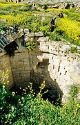 Well
Well -
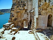
 Inside the western gate
 -
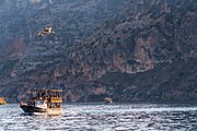 Boats around Rumkale


References
[edit]- ^Sarafean, Georg Avedis (1957).A Briefer History of Aintab A Concise History of the Cultural, Religious, Educational, Political, Industrial and Commercial Life of the Armenians of Aintab.Boston: Union of the Armenians of Aintab. p. 27.Retrieved4 September2022.
- ^Öcal, Mehmet; Güler, Selahaddin E.; Mızrak, Remzi (2001).Şanlıurfa kültürü sözlüğü.Şurkav Yayınları. p. 39.ISBN9789757394235.Retrieved18 November2022.
- ^Comfort, Abadie-Reynal & Ergeç 2000,p. 113.
- ^"Roman Castle to open to tourism".Hürriyet Daily News.Retrieved2020-03-28.
- ^Dadoyan 2012,p. 41.
- ^van Lint 1999,p. 32.
- ^Russel 2005,p. 201.
- ^abEvans 2008,p. 141.
- ^Hamilton 1999,pp. 4–5.
- ^"Eastern Churches" by James Darling, London 1850, page 35, paragraph 2
Sources
[edit]- Comfort, Anthony; Abadie-Reynal, Catherine; Ergeç, Rifat (December 2000)."Crossing the Euphrates in antiquity: Zeugma seen from space".Anatolian Studies.50:99–126.doi:10.2307/3643016.JSTOR3643016.Retrieved27 February2024.
- Dadoyan, Seta B. (1 November 2012).The Armenians in the Medieval Islamic World: Armenian Realpolitik in the Islamic World and Diverging Paradigmscase of Cilicia Eleventh to Fourteenth C.Transaction Publishers.ISBN978-1-4128-4782-7.Retrieved25 February2024.
- Evans, Helen C. (2008). "Hromkla".Armenia - Art, Religion, and Trade in the Middle Ages.Metropolitan Museum of Art.ISBN9781588396600.Retrieved27 February2024.
- Hamilton, B. (1999). "Aimery of Limoges and the Unity of Churches". In Ciggaar, Krijna Nelly; Teule, Herman G. B. (eds.).East and West in the Crusader States: Context, Contacts, Confrontations II: Acta of the Congress Held at Hernen Castle in May 1997.Peeters Publishers. pp. 1–12.ISBN978-90-429-0786-7.Retrieved26 February2024.
- van Lint, Theo M. (1999). "Lament on Edessa by Nerses Snorhali". In Ciggaar, Krijna Nelly; Teule, Herman G. B. (eds.).East and West in the Crusader States: Context, Contacts, Confrontations II: Acta of the Congress Held at Hernen Castle in May 1997.Peeters Publishers. pp. 29–48.ISBN978-90-429-0786-7.Retrieved26 February2024.
- Russel, James R. (2005). "The Credal Poem Hawatov Xostovanim (" I confess in faith ") of St. Nerses the Graceful". In Ginkel, Jan J.; Murre-van den Berg, Hendrika Lena; Lint, Theo Maarten van (eds.).Redefining Christian Identity: Cultural Interaction in the Middle East Since the Rise of Islam.Peeters Publishers. pp. 185–236.ISBN978-90-429-1418-6.Retrieved26 February2024.
- Stewart, Angus (2006), 'Hromgla', in Alan V. Murray (ed.),The Crusades: An Encyclopaedia,II, p. 607. ABC-CLIO, Inc.,ISBN1-57607-862-0
- Reuven Amitai-Preiss(1995),Mongols and Mamluks: The Mamluk-Īlkhānid War, 1260-1281,pp. 179–225. Cambridge University Press,ISBN0-521-46226-6.

