
Saarburg
This articleneeds additional citations forverification.(June 2023) |
Saarburg | |
|---|---|
 | |
 Coat of arms | |
Location of Saarburg within Trier-Saarburg district  | |
 Saarburg  Saarburg | |
| Coordinates:49°37′N6°33′E/ 49.617°N 6.550°E | |
| Country | Germany |
| State | Rhineland-Palatinate |
| District | Trier-Saarburg |
| Municipal assoc. | Saarburg-Kell |
| Subdivisions | 4 |
| Government | |
| •Mayor(2019–24) | Jürgen Dixius[1](CDU) |
| Area | |
| • Total | 20.63 km2(7.97 sq mi) |
| Elevation | 159 m (522 ft) |
| Population (2022-12-31)[2] | |
| • Total | 7,597 |
| • Density | 370/km2(950/sq mi) |
| Time zone | UTC+01:00(CET) |
| • Summer (DST) | UTC+02:00(CEST) |
| Postal codes | 54439 |
| Dialling codes | 06581 |
| Vehicle registration | TR, SAB |
| Website | saarburg.de |
Saarburg(German pronunciation:[ˈzaːɐ̯bʊʁk],[ˈzaːɐ̯bʊʁç]) is acityof theTrier-Saarburgdistrict, in the state ofRhineland-Palatinate,Germany,on the banks of the riverSaarin the hilly country a few kilometers upstream from the Saar's junction with theMoselle.Now known as a tourist attraction, the river Leuk flows into the town centre and makes a spectacular drop of some 60 feet before joining the larger Saar that bisects the town. The waterfall is the result of a 13th-century project to redirect the Leuk through the city centre.
Saarburg is the seat of theVerbandsgemeinde( "collective municipality" )Saarburg-Kell.The area around Saarburg is noted for the cultivation ofRieslinggrapes.
History
[edit]
The history of the city begins with the construction of the now-ruined castle by GrafSiegfried of Luxembourgin 964. It received its town charter in 1291. The city has abellfoundry,the Glockengießerei Mabilion, which has been in operation since the 1770s, and as of 2003[update]the only one in Germany that producesbronzebells.
From 1945 to 1948 Saarburg was occupied by troops fromLuxembourg.From 18 July 1946 to 6 June 1947Onsdorf,in its then municipal boundary, formed part of theSaar Protectorate.French troops complemented the occupation until 1955.
Saarburg has a proud history with bells, being the producers of bells for many German cathedrals.
Gallery
[edit]-
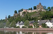 Saarburg, castle, Ober- und Unterstadt
 -
 Catholic church (Pfarrkirche Sankt Laurentius)
 -
 Reformed church and the river Saar
 -
 Stained glass by Werner Persy in the Protestant Church Saarburg


Twin towns — sister cities
[edit]Saarburg istwinnedwith:
 Sarrebourg,France (1952)
- Soulac-sur-Mer,France (1972)
Born in Saarburg
[edit]- Marianne Baum(1912–1942), resistance fighter against Nazism
- Erwin Menny(1893–1949), lieutenant general in the Second World War
- Alexander von Warsberg(1836–1889), Austrian government official and travel writer
References
[edit]- ^Direktwahlen 2019, Landkreis Trier-Saarburg,Landeswahlleiter Rheinland-Pfalz, accessed 2 August 2021.
- ^"Bevölkerungsstand 2022, Kreise, Gemeinden, Verbandsgemeinden"(PDF)(in German).Statistisches Landesamt Rheinland-Pfalz.2023.
External links
[edit]
| International | |
|---|---|
| National | |
| Geographic | |
ThisTrier-Saarburglocation article is astub.You can help Wikipedia byexpanding it. |