
Sabalan
This article includes a list of generalreferences,butit lacks sufficient correspondinginline citations.(March 2016) |
| Sabalan(Savalan) | |
|---|---|
 Mount Sabalan | |
| Highest point | |
| Elevation | 4,811 m (15,784 ft)[1] |
| Prominence | 3,283 m (10,771 ft)[1] Ranked 66th |
| Listing | Ultra |
| Coordinates | 38°16′01″N47°50′13″E/ 38.26694°N 47.83694°E[1] |
| Geography | |
 Sabalan(Savalan) Location in Iran | |
| Location | Meshkinshahr,Iran. |
| Geology | |
| Age of rock | 5.6–1.4 million years |
| Mountain type | Stratovolcano |
| Last eruption | Unknown, possiblyHolocene. |
| Climbing | |
| Easiest route | hiking/scrambling |
SabalanorSavalan(native:ساوالان[sævæ'lɒːn])[2]is an inactivestratovolcanoin northwesternIranlocated inArdabil province.
At 4,794 metres (15,728 ft) above sea level, it is the third-highest mountain in Iran. A permanentcrater lakehas formed at its summit. On one of its slopes around 3,600 metres (11,800 ft) there are large rock formations of eroded volcanic outcrops that resemble animals, birds, and insects.

Mount Savalan
[edit]Located in the extreme northwest of Iran, Savalan is the country's third-highest peak afterDamavandandAlam-Kuh.It is also slightly higher thanMont Blancin theAlps.
The mountain offers many attractions throughout the year. On the slopes of the mountain, themineral waterfromspringsattracts large numbers of tourists each year, many of whom have faith in healing properties attributed to the springs. The nomadic people of the area live in small villages, with their round "Yurt" tents appealing to tourists. Savalan has a ski resort (Alvares) and different tourist areas such as theSareinspa. The mountain is known for its beautiful vistas, including the Shirvan gorge, where few climbers venture.
Geology
[edit]Sabalan is a largeandesitestratovolcano in Meshgin Shahr, inArdabil Provincein Iran. It is the second-highest volcano afterMount Damavand.The volcano is quite old. Its first eruptions occurred in theEoceneand later in theMiocene.But the main volcanism happened in thePlioceneand thePleistoceneas some of its rocks have been dated to 5–1.4 million years. Some references state that volcanic activity continued into theHolocene,less than 10,000 years ago.
The summit region has several peaks exceeding 4,500 metres (14,800 ft), primarily along a southwest-northeast trending ridge. The highest point 4,791 metres (15,719 ft) is at the northeast end of the ridge and is separated from the 4,620 metres (15,160 ft)+ group of southwestern summits by a 4,190 m (13,750 ft)col.
The mountain is located in acontinental climatewith hot, dry summers and extremely cold, snowy winters. Precipitation falls primarily assnowin late autumn, winter, and spring, and is sufficient to sustain sevenglaciersnear the summit above 4,000 metres (13,000 ft). The largest of these were more than 1.5 kilometres (1 mi) in length as of the 1970s. There are also extensiverock glaciers,several of which are more than 3 km (2 mi) in length.
Climbing
[edit]The climbing surface includes rocks of various size (Class 2scrambling), and a moderate degree of fitness is required to climb it. The climb from the base camp starts easy, becomes challenging midway, then eases in gradient near the top. The lake on the top remains frozen except for about four weeks in late July to early August.
Some climbers start by driving tohot springsof Meshgin Shahr, where they start their climb. This climb takes about two days, reaching the base camp on the first day. Others take a taxi to base camp early in the morning and climb the mountain in one day. In 2006, there was talk of improving the road to the base camp. If this is done, a regular car should be able to make it to the base camp during the climbing season. The road goes through multiple nomadic encampments of shepherds.
One or two days ofacclimatizationinTehranorArdabilmay be advisable.Mountaineeringhas been popular among the youth in Iran. On a Friday during theclimbingseason (late June to mid-August), one may find hundreds of people on the mountain. Guides can also be found in Ardabil. Adequate climbing equipment can be purchased in Ardabil or Tehran.
Surrounding area
[edit]The area around Sabalan, particularly nearMeshkin,sarab city andardabil city,[3]produces large quantities of grain, including wheat. Due to the microclimate produced by the mountain, Ardabil remains pleasantly cool in the summers.
There are numerous hot springs around the slopes of Sabalan, with the main concentration withinSareyn County.
There are skiing slopes, with snow even in near-summer. Aski resortnamed "Alvares" is within an hour's drive fromSareynon the south ridge of Sabalan.

Gallery
[edit]-
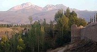 Arshoq Castle inMeshgin Shahrin foreground, Sabalan in background
 -
 Shelter on Sabalan at 3,600 m
 -
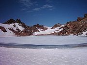 Crater lake of Sabalan
 -
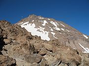 Sabalan landscape at 4,100 m
 -
 Igneous rock,Mr. Sabalan,Iran


See also
[edit]References
[edit]- ^abc"Iran: 54 Mountain Summits with Prominence of 1,500 meters or greater"Peaklist.org. Retrieved 2011-11-21.
- ^Taranov, Andrey (2012).Turkish vocabulary for English speakers - 9000 words (American English Collection).T&P Books.ISBN978-1780712925.
- ^https:// mcth.ir/[bare URL]
- "Sabalan".Global Volcanism Program.Smithsonian Institution.Retrieved2021-06-24.
- Williams, Richard S. Jr; Ferrigno, Jane G., eds. (1991).Satellite Image Atlas of Glaciers of the World -- Middle East and Africa.USGSProfessional Paper 1386-G. pp. 37–39.
- Peaklist.org: Iran Mountain Ultra-Prominence
Sources
[edit]- Chehabi, H. E. (1997). "Ardabil Becomes a Province: Center-Periphery Relations in Iran".International Journal of Middle East Studies.29(2): 235–253.doi:10.1017/S0020743800064485.JSTOR164018.S2CID162201104.(registration required)