
Samnaun Alps
| Samnaun Alps | |
|---|---|
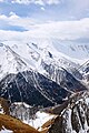
 Muttler (left) and Piz Tschütta (right) | |
| Highest point | |
| Peak | Muttler |
| Elevation | 3,293 m (10,804 ft) |
| Coordinates | 46°54′1″N10°22′42″E/ 46.90028°N 10.37833°E |
| Geography | |

| |
| Countries | Austria and Switzerland |
| States | TyrolandGraubünden |
| Parent range | Central Eastern Alps |
| Borders on | Verwall Alps, Silvretta, Sesvenna Range and Ötztal Alps |
TheSamnaun Alpsare amountain rangeof theCentral Eastern Alps,named after the Swiss municipality ofSamnaun.They are located at the border of theAustrianstate ofTyroland theGraubündencanton ofSwitzerland.
The Samnaun Alps are separated from theSesvenna Alpsin the south by the Engadine Valley; from theSilvretta Alpsin the west by the Fimber Pass; from theVerwall Alpsand theLechtal Alpsin the north by thePaznauntal;from theÖtztal Alpsin the east by theInnvalley. All the range is drained by the river Inn, through the Trisanna, Schergenbach, Brancla and Fimbabach.
Peaks
[edit]The range includes the following peaks:
| Peak | Elevation (m/ft) | |
|---|---|---|
| Muttler | 3293 | 10,804 |
| Piz Tschütta | 3258 | 10,689 |
| Piz Mundin | 3146 | 10,322 |
| Vesilspitze | 3115 | 10,220 |
| Piz Rots | 3097 | 10,161 |
| Vesulspitze | 3092 | 10,145 |
| Hexenkopf | 3038 | 9,968 |
| Piz Malmurainza | 3038 | 9,968 |
| Bürkelkopf | 3033 | 9,951 |
| Gemspleiskopf | 3017 | 9,899 |
| Furgler | 3004 | 9,856 |
| Rothbleiskopf | 2938 | 9,640 |
| Flimspitz | 2929 | 9610 |
| Grübelekopf | 2894 | 9495 |
| Palinkopf | 2864 | 9396 |
For a list of passes, seePasses of the Silvretta and Rätikon Ranges.
-
 Muttler from north
 -
 Fimbatalborder crossing Switzerland and Austria
 -
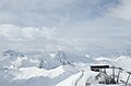 Piz Rots in the skiareaSilvretta Arena
 -
 Piz Mundin and Muttler from east (Nauders)


See also
[edit]
| International | |
|---|---|
| National | |
This article about a mountain, mountain range, or peak located inGraubündenis astub.You can help Wikipedia byexpanding it. |
ThisTyrollocation article is astub.You can help Wikipedia byexpanding it. |