Skerry
This articleneeds additional citations forverification.(September 2009) |


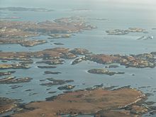
Askerry(/ˈskɛri/SKEHRR-ee)[1]is a small rockyisland,orislet,usually too small for human habitation. It may simply be a rockyreef.A skerry can also be called a lowsea stack.[2]
A skerry may have vegetative life such asmossand small, hardy grasses. They are often used as resting places by animals such assealsandbirds.
Etymology
[edit]The termskerryis derived from theOld Norsesker,which means a small rocky island in the sea (which in turn derives from theProto-Indo-Europeanroot *sker-, "cut", in the sense of a rock cut off from the land).[3]The Old Norse termskerwas brought into the English language via theScots languageword spelledskerrieorskerry.It is acognateof theScandinavian languages' words forskerry–Icelandic,Faroese:sker,Danish:skær,Swedish:skär,Norwegian:skjær / skjer,found also inGerman:Schäre,Finnish:kari,Estonian:skäär,Latvian:šēra,Lithuanian:šcherasandRussian:шхеры(shkhery). InScottish Gaelic,it appears assgeir,e.g.Sula Sgeir,inIrishassceir,inWelshassgeri,and inManxasskeyr.
Formation
[edit]Skerries are most commonly formed at the outlet offjordswhere submerged glacially formedvalleysat right angles to thecoastjoin with other cross valleys in a complex array. In some places near the seaward margins of fjorded areas, the ice-scouredchannelsare so numerous and varied in direction that the rocky coast is divided into thousands of island blocks, some large and mountainous, while others are merely rocky points or rockreefsthat menace navigation.
Examples
[edit]
The island fringe of Norway is such a group of glacially formed skerries, called askjærgård(sometimes translated into English as archipelago, but specifically one near the coast of the mainland). Many of the cross fjords are so arranged that they parallel the coast and provide a protected channel behind an almost unbroken succession of rocky islands and skerries. By this channel one can travel through a protected passage almost the entire 1,600 km (1,000 mi) route fromStavangertoNorth Cape,Norway. TheBlindleiais a skerry-protected waterway that starts nearKristiansandin southernNorwayand continues pastLillesand.
TheInside Passageprovides a similar route fromSeattle,Washington,toSkagway,Alaska,United States. Another such skerry-protected passage extends from theStraits of Magellannorth for 800 km (500 mi) along the west coast of the South American continent.
TheSwedishcoast alongBohuslänis likewise guarded by skerries. Even the east coast of Sweden, in theBaltic Sea,has many bigskärgårdar(archipelagos), notablyStockholm Archipelago.
The southwestern coast ofFinlandalso has a great many skerries; so many, in fact, that they form anarchipelago.This area is experiencingpost-glacial reboundthat connects the rising islands as they break sea level, revealing till deposits and eventually clay bottoms. The skerries exist as small rocky islands before uplift of adjacent terrain changes the classification of this landform into atombolo.[4]
In theRussian Federation,the best examples are theMinina Skerries,located in theKara Sea,in the western shores of theTaymyr Peninsula,and theSumsky Skerries,located in theWhite Sea.
The United Kingdom has a large number of skerries includingStaple Island(an outerFarne Island) in England; a small rocky outcrop near theFowlsheughin northeast Scotland; numerous reefs in theHebridessuch asDubh ArtachandSkerryvore;andThe Skerries,located off the Antrim coast of Northern Ireland.
Skerriesis the name of a coastal area ofDublin,Ireland, with many skerries offshore, includingRockabill,Shenick Island,Colt IslandandSt Patrick's Island.
References
[edit]- ^"SKERRY definition and meaning".Collins English Dictionary.
- ^Johnson, Markes E.; Webb, Gregory E. (1 September 2007)."Outer Rocky Shores of the Mowanbini Archipelago, Devonian Reef Complex, Canning Basin, Western Australia"(PDF).The Journal of Geology.115(5): 583–600.Bibcode:2007JG....115..583J.doi:10.1086/519779.S2CID129190899.
- ^"Indo-European root sker-".
- ^Tolvanen, Harri; Numminen, Samu; Kalliola, Risto (1 January 2004). "Spatial Distribution and Dynamics of Special Shore-Forms (Tombolos, Flads and Glo-lakes) in an Uplifting Archipelago of the Baltic Sea".Journal of Coastal Research.20(1): 234–243.doi:10.2112/1551-5036(2004)20[234:SDADOS]2.0.CO;2.JSTOR4299279.S2CID130519270.
External links
[edit] Media related toSkerriesat Wikimedia Commons


