Slope Point
46°40′31.39″S169°00′20.34″E/ 46.6753861°S 169.0056500°E

Slope Pointis the southernmost point of theSouth Islandof New Zealand.[1]
Slope Point lies 24 kilometres (15 mi) south of the small settlement ofWaikawa,[2]near the southwestern edge ofthe CatlinsandToetoes Bayand 70 kilometres (43 mi) east ofInvercargill.A nearby locality—Haldane—was named after the original European settlers, the Haldane family.[1]
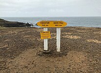
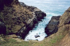
The land around Slope Point is used forsheep farmingwith no houses anywhere nearby.Erodedcliffs drop down to the sea below. AnAAsignpost there shows the distance to theEquatorand theSouth Pole,and a smallsolar-poweredlighthousestands on farmland.[1]
There is no road to Slope Point; it can be reached by a 20-minute walk following dilapidated yellow markers. Its latitude, longitude is approximately 46.67 S, 169.00 E. There is no public access during the lambing season (September – November).[1]
 |
 |
See also
[edit]References
[edit]- ^abcdWade, Pamela (26 August 2018)."World famous in New Zealand: Slope Point, Southland".Stuff.Retrieved24 January2023.
- ^"Slope Point".Catlins Coast Inc.Retrieved24 January2023.
