
Slovene Littoral
This articleneeds additional citations forverification.(January 2013) |

TheSlovene Littoral,or simplyLittoral(Slovene:Primorska,pronounced[pɾiˈmóːɾska];[1]Italian:Litorale;German:Küstenland), is one of thetraditional regionsofSlovenia.Thelittoralin its name – for a coastal-adjacent area – recalls the formerAustrian Littoral(Avstrijsko Primorje), theHabsburgpossessions on the upperAdriaticcoast, of which the Slovene Littoral was part. Today, the Littoral is often associated with the Slovenian ethnic territory that, in the first half of the 20th century, found itself in Italy to the west of theRapallo Border,which separated a quarter ofSlovenesfrom the rest of the nation,[2]and was strongly influenced byItalian fascism.[3][4]
Geography
[edit]The region forms the westernmost part of Slovenia, bordering the inter-municipal union of Giuliana in the region ofFriuli-Venezia GiuliaofItaly.It stretches from the Adriatic Sea in the south up to theJulian Alpsin the north.
The Slovene Littoral comprises two traditional provinces:GoriškaandSlovene Istria.The Goriška region takes its name from the town ofGorizia(Slovene:Gorica) now inItaly;the neighbouringconurbationofNova GoricaandŠempeter-Vrtojbatoday is the urban centre of the Slovene Littoral. Slovene Istria comprises the northern part of theIstriapeninsula and provides, on theSlovene Rivieracoastline with the ports ofKoper,Izola,andPiran,the country's only access to the sea.
AfterLjubljana,the Slovene Littoral is the most developed and economically prosperous part of Slovenia. The western part of Slovene Istria is a bilingual region where both Slovene andItalianmay be used in education, legal and administrative environments.
The northern part of the Slovene Littoral is part of the largerGorizia Statistical Region,and the south belongs to theCoastal–Karst Statistical Region.
History
[edit]
After they had acquired theCarniolahinterland in 1335, the Habsburgs gradually took possession of the coastal areas. In the second half of the 14th century, they acquired Postojna and the UpperVipava Valleyfrom thePatriarchate of Aquileia,followed byDuinoand parts of the Karst Plateau. These areas were annexed to Carniola, though they maintained a separate identity well into the Early Modern Age.[7]In 1500 the Habsburgs inherited the comital lands ofGorizia(Görz), when the last CountLeonhard of Goriziadied childless. The HabsburgPrincely County of Gorizia and Gradiscawas established in 1754, it became part of theAustrianKingdom ofIllyriain 1816. With the Istrian march and theImperial Free City of Trieste,it was re-arranged as the Austrian Littoralcrown landin 1849.
At the end ofWorld War Iand the dissolution ofAustria-Hungaryin 1918, the area, together with the western part ofInner Carniolaand theUpper Carniolanmunicipality of Bela Peč / Weissenfels (later Italianized to Fusine in Valromana, now afrazioneofTarvisio), was occupied by theItalianarmy. As stipulated in the 1915London Pact,a quarter of predominantly Slovene ethnic territory and approximately 327,000[6]out of the total population of 1.3[5]million Slovenes were adjudicated to Italy by the 1919Treaty of Saint-Germainand finally annexed according to the 1920 borderTreaty of Rapallo.
Incorporated into theJulian March(Venezia Giulia) a forcedItalianizationof theSlovene minoritybegan, intensified after the Fascists underBenito Mussolinicame to power in 1922, andlasted until 1943.The Slovenes in Italy lacked any minority protection under international or domestic law.[8]Numerous Slovenes emigrated to theKingdom of Yugoslavia,others fought against Italian rule in the anti-fascistTIGRorganization.
AfterWorld War II,according to the 1947Paris Peace Treaties,the bulk of the region with the upperSoča(Isonzo) Valley fell toYugoslavia.Parts of the area were re-arranged as theFree Territory of Trieste,whileItalyretained the urban centres of Gorizia andGradisca.In 1954 Italy also recovered the main port ofTrieste.As a result, the new urban centres on the Slovenian side of the border developed.
Gallery
[edit]-
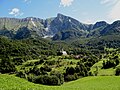 Mount Krn in theJulian Alps
 -
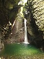 Kozjak Falls in theSočaValley
 -
 TheGorizia Hillswine region
 -
 The town ofNova Gorica
 -
 TheNanos Plateauabove theVipava Valley
 -
-
 Rural architecture inŠtanjel,in the municipality of Komen
 -
 A herd of sheep on theKarst Plateau
 -
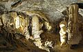
 Škocjan Caves,a UNESCO site
 -
 Landscape inSlovene Istria
 -
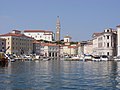 The Adriatic town ofPiran
 -

-
-
 Olmsin Postojna Cave
 -


See also
[edit]- Battles of the Isonzo
- Goriška
- Morgan Line
- Treaty of Osimo
- Karst Plateau
- Vipava Valley
- Soča
- Slovenian wine
- Venetian Slovenia
References
[edit]- ^"Slovenski pravopis 2001: Primorska".
- ^"Določitev slovenske zahodne meje v 20. stoletju"[The Determination of Slovenia's Western Border in the 20th Century] (in Slovenian).Museum of Contemporary History of Slovenia.Retrieved26 January2024.
- ^Humar, Vesna (Winter 2017)."Nova Primorska ali kaj imajo skupnega pastirji in mornarji"[Tne New Littoral or what Shepherds and Sailors Have in Common].Razpotja(in Slovenian) (29).
- ^Geršič, Matjaž (2017). "Changing Denotations of Selected Slovenian Choronyms" [Spreminjanje denotata izbranih slovenskih pokrajinskih imen].Acta geographica Sovenica(in English and Slovenian).57(1). ZRC SAZU.COBISS40099117.
- ^abLipušček, U. (2012)Sacro egoismo: Slovenci v krempljih tajnega londonskega pakta 1915,Cankarjeva založba, Ljubljana.ISBN978-961-231-871-0
- ^abCresciani, Gianfranco (2004)Clash of civilisations,Italian Historical Society Journal, Vol.12, No.2, p.4
- ^Miha Kosi, Spopad za prehode proti Jadranu in nastanek dežele Kras (Ljubljana: ZRC SAZU, 2018)
- ^Hehn, Paul N. (2005).A Low Dishonest Decade: The Great Powers, Eastern Europe, and the Economic Origins of World War II, 1930–1941.Continuum International Publishing Group. pp. 44–45.ISBN0-8264-1761-2.
External links
[edit] Media related toSlovene Littoralat Wikimedia Commons
45°59′21.58″N13°48′35.33″E/ 45.9893278°N 13.8098139°E
| International | |
|---|---|
| National | |