
Surveyor 1
This articleneeds additional citations forverification.(May 2020) |
 Surveyor model on Earth | |
| Mission type | Lunarlander |
|---|---|
| Operator | NASA |
| COSPAR ID | 1966-045A |
| SATCATno. | 02185 |
| Mission duration | 7 months, 8 days (launch to last contact) |
| Spacecraft properties | |
| Manufacturer | Hughes Aircraft |
| Launch mass | 995.2 kilograms (2,194 lb)[1] |
| Landing mass | 292 kilograms (644 lb) |
| Start of mission | |
| Launch date | May 30, 1966, 14:41:01UTC |
| Rocket | Atlas LV-3C Centaur-DAC-10 |
| Launch site | Cape CanaveralLC-36A |
| End of mission | |
| Last contact | 7 January 1967 |
| Lunarlander | |
| Landing date | June 2, 1966, 06:17:36 UTC[2] |
| Landing site | 2°28′26″S43°20′20″W/ 2.474°S 43.339°W[2] |
Surveyor 1was the firstlunar soft-landerin the uncrewedSurveyor programof theNational Aeronautics and Space Administration(NASA,United States). Thislunarsoft-lander gathered data about the lunar surface that would be needed for the crewedApollo Moon landingsthat began in 1969. The successful soft landing of Surveyor 1 on theOcean of Stormswas the first by an Americanspace probeon anyextraterrestrial body,[3]occurring on the first attempt and just four months after the first soft Moon landing by the Soviet Union'sLuna 9probe.
Surveyor 1 was launched May 30, 1966, from theCape Canaveral Air Force StationatCape Canaveral, Florida,and it landed on the Moon on June 2, 1966. Surveyor 1 transmitted 11,237 still photos of the lunar surface tothe Earthby using a television camera and a sophisticatedradio-telemetrysystem.
The Surveyor program was managed by theJet Propulsion Laboratory,inLos Angeles County, California,and the Surveyor space probe was built by theHughes Aircraft CompanyinEl Segundo, California.
Mission description[edit]


The Surveyor series ofspace probeswas designed to carry out the first soft landings on the Moon by any Americanspacecraft.No instrumentation was carried specifically for scientific experiments by Surveyor 1, but considerable scientific data were collected by itstelevision cameraand then returned to Earth via theDeep Space Networkfrom 1966 to 1967. These spacecraft carried two television cameras — one for its approach, which was not used in this case, and one for taking still pictures of the lunar surface. Over 100 engineering sensors were on board each Surveyor. Their television systems transmitted pictures of the spacecraft footpad and surrounding lunar terrain and surface materials. These spacecraft also acquired data on the radar reflectivity of the lunar surface, the load-bearing strength of thelunar surface,and the temperatures for use in the analysis of the lunar surface temperatures. (Later Surveyor space probes, beginning withSurveyor 3,carried scientific instruments to measure the composition andmechanical propertiesof the lunar "soil".)
Surveyor 1 was launched May 30, 1966 and sent directly into a trajectory to the Moon without anyparking orbit.Itsretrorocketswere turned off at a height of about 3.4metersabove the lunar surface. Surveyor 1 fell freely to the surface from this height, and it landed on the lunar surface on June 2, 1966, on theOceanus Procellarum.This location was at2°28′26″S43°20′20″W/ 2.474°S 43.339°W.[2]This is within the northeast portion of the large crater called Flamsteed P (or theFlamsteed Ring).Flamsteeditself lies within Flamsteed P on the south side.
The duration of thespaceflightof Surveyor 1 was about 63 hours, 30 minutes. Surveyor 1's lunar launch weight was about 995.2 kilograms (2,194 lb), and its landing weight (minus expended maneuvering propellant, itssolid-fueledretrorocket (which had been jettisoned), and itsradar altimetersystem) was about 294.3 kilograms (649 lb).
Surveyor 1 transmittedvideodata from the Moon beginning shortly after its landing through July 14, 1966, but with a period of no operations during the two-week long lunar night of June 14, 1966 through July 7, 1966. Because the Moon always presents the same face to Earth, "line-of-sight"radio communicationswith Surveyor 1 required only changes in ground stations as the Earth rotated. However, since it was solar-powered, Surveyor 1 had no electricity with which to function during the two weeks of the lunar night.
The return of engineering information (temperatures, etc.) from Surveyor 1 continued through January 7, 1967, with several interruptions during the lunar nights.
The landing of Surveyor 1 was carried live on some television networks, and the success of the first Surveyor landing was considered surprising, especially after the failure of a number of theRanger spacecraften route to the Moon. Justin Rennilson, formerly ofJet Propulsion Laboratory,stated, "We figured the probability of success at around 10 to 15 percent." Among hundreds of other challenges, an uninterrupted communication link for navigation and control was critical to success.[4]
Science instruments[edit]
Television[edit]

The TV camera consisted of avidicontube, a zoom lens operated at either end of its range resulting in 25 millimeter and 100 millimeter focal-lengths, resulting in optical fields of view of 25.3 or 6.43 degrees, a shutter, clear, orange, green and blue optical filters,[5]andiris-system mounted along an axis inclined approximately 16 degrees from the central axis of Surveyor 1. The camera was mounted under a mirror that could be moved in azimuth and elevation. The rotation of the mirror in the azimuth direction, while providing azimuth coverage capability results in an image rotation proportional to the angular azimuth position of the mirror. This is because the image plane and scanning raster of the vidicon are stationary with respect to the mirror azimuth axis. The mirror drive mechanism consisting of stepper motors provided a step size of 2.48° ±0.1° in elevation and 3.0° ±0.1° in azimuth. This calibrated stepping reference allowed the creation of large composite mosaics of the lunar surface and using the data read-back from the iris and focus positioning of the lens permitted some photogrammetric measurements of various lunar features.[6]The TV camera's operation was dependent on the receipt of the proper radio commands from the Earth. Frame-by-frame coverage of the lunar surface was obtained over 360 degrees in azimuth and from +40 degrees above the plane normal to the camera's axis to -65 degrees below this plane. Both 600-line and 200-line modes of operation were used. The 200-line mode transmitted over an omnidirectional antenna for the first 14 photos and scanned one frame every 61.8 seconds. The remaining transmissions were of 600-line pictures over a directional antenna, and each frame was scanned every 3.6 seconds. Each 200-line picture required 20 seconds for a complete video transmission and it used aradio bandwidthof about 1.2kilohertz.
Each 600-line picture required about one second to be read from the vidicon tube, and they required aradio bandwidthof about 220 kilohertz. The data transmissions were converted into a standard TV signal for bothclosed-circuit TVandbroadcast TV.The television images were displayed on Earth on a slow-scan monitor coated with a long persistency phosphor. The persistency was selected to optimally match the nominal maximum frame rate. One frame of TV identification was received for each incoming TV frame, and it was displayed in real time at a rate compatible with the incoming image. These data were recorded on a video magnetic tape recorder. Over 10,000 pictures were taken by Surveyor 1's TV camera before the lunar sunset of June 14, 1966. Included in these pictures were wide-angle and narrow-angle panoramas, focus ranging surveys, photometric surveys, special area surveys, and celestial photography. Surveyor 1 responded to commands to activate the camera on July 7, and by July 14, 1966, it had returned nearly 1000 more pictures.
-
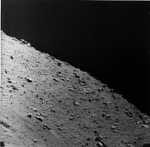
 Surveyor 1's shadow against the lunar surface (upside-down image)
 -
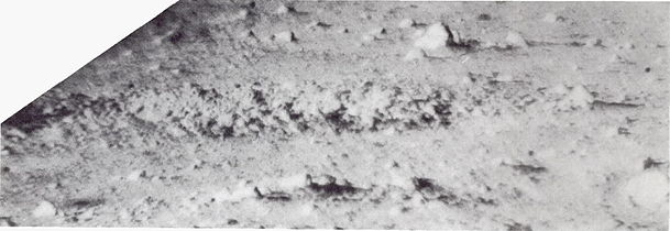
 The mare surface
 -
 Another view of the mare surface
 -
 Irregularly shaped crater at the landing site
 -
 Mottled rock about 50 cm long near Surveyor 1


Strain gauge[edit]
Strain gauges were mounted on each leg shock absorber to record the peak axial forces at landing impact of the spacecraft. They were designed to accept a force of approximately 800kgf(7.8 kN).
Legacy and status[edit]
On January 6, 1967, Surveyor 1 was reactivated for 12 hours. The spacecraft returned data on the motion of the Moon, which would be used to refine the map of its orbital path around the Earth as well as better determine the distance between the two worlds.[7]
See also[edit]
References[edit]
- ^"Surveyor 1".NASA's Solar System Exploration website.RetrievedDecember 2,2022.
- ^abc"Surveyor 1".NASA Space Science Data Coordinated Archive. 2014-08-26.Retrieved2015-06-01.
- ^"Chandrayaan-2 landing: 40% lunar missions in last 60 years failed, finds Nasa report".
- ^Pyle, Rod (2 June 2016)."Fifty Years of Moon Dust: Surveyor 1 was a Pathfinder for Apollo".NASA.Retrieved12 March2017.
- ^NASA SP-184 - SURVEYOR Program Results(PDF).NASA. 1969. p. 109.
- ^Montgomery, WolfThe Surveyor lunar landing television system.IEEE Spectrum, August 1966, p. 55-56
- ^"Aeronautics and Astronautics, 1967"(PDF).NASA. p. 5.Retrieved21 December2021.
External links[edit]
- Surveyor 1 digitized panorama with color photometric target,from Surveyor Digitization Project
- Surveyor 1: 50 Years LateronYouTube
- Panoramas of the Surveyor 1 landing site,from The International Atlas of Lunar Exploration by Philip J. Stooke
- Surveyor Program Results (PDF) 1969
- Surveyor I – A Preliminary Report – June 1, 1966 (PDF)
- Surveyor I mission report. Part II – Scientific data and results – Sep 1966 (PDF)
- Details of Surveyor 1 launch, and also more on the Surveyor program
- Surveyor I imagesat Lunar and Planetary Institute
- Surveyor Site 1 Lunar Mapat Lunar and Planetary Institute
- Surveyor Site 1 Lunar PhotoMapat Lunar and Planetary Institute
- Lunar Orbiter 1 photo 192,showing the northeastern part of Flamsteed P crater, where Surveyor 1 landed