Sutro Tower
| Sutro Tower | |
|---|---|
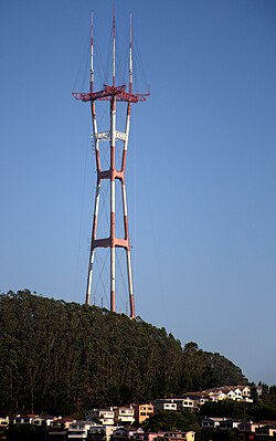
 Sutro Tower viewed from Grandview Park in San Francisco | |
| General information | |
| Status | Completed |
| Type | Radio mast |
| Location | San Francisco, California |
| Address | 1 La Avanzada Street Clarendon Heights |
| Coordinates | 37°45′19″N122°27′10″W/ 37.75523°N 122.45284°W |
| Elevation | 254.2 m (834 ft) |
| Completed | July 4, 1973 |
| Owner | Sutro Tower, Inc. |
| Height | |
| Antenna spire | 297.8 m (977 ft)[1] |
| Observatory | on Level 6, 228.8 m (751 ft) above base |
| Dimensions | |
| Other dimensions |
|
| Technical details | |
| Structural system | Truss tower |
| Design and construction | |
| Architect(s) | Furman L. Anderson Jr.[2] |
| Architecture firm |
|
| Renovating team | |
| Engineer | Simpson Gumpertz & Heger |
| Website | |
| sutrotower | |
| References | |
| [3][4][5] | |
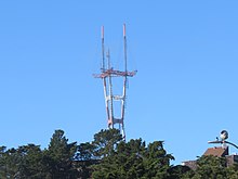
Sutro Toweris a unique three-legged 297.8 m (977 ft) tall TV and radiolattice towerlocated in San Francisco, California. Rising from a hill betweenTwin PeaksandMount SutronearClarendon Heights,it is a prominent feature of the city skyline and a landmark for city residents and visitors. The tower was the tallest structure in San Francisco from the time of its completion in 1973 until it was surpassed by theSalesforce Towerin 2018.
The tower is named after Mount Sutro.[6]Adolph Gilbert Sutro, grandson of former mayorAdolph Sutro,built a mansion,La Avanzada,on the family property in the highest peaks of San Francisco. In 1948, the mansion and property was sold to theAmerican Broadcasting Company,where it became the original home of their San Francisco operation asKGO Television.KGO then formed a consortium withKTVU,KRON,andKPIX,the three other major San Francisco television broadcasters at the time, to build and maintain the tower. It stands 297.8 m (977 ft) above ground and 552 m (1,811 ft) above sea level. It is the second tallest structure in the city by ground-to-tip height, though its mountain location overlooks the city's downtown skyscrapers.
History
[edit]
Before the construction of Sutro Tower in 1973, television reception in San Francisco was spotty because the many hills of the city blocked the line-of-sight television signal. The great height of the new tower helped to resolve that problem. Transmitters had been scattered throughout the Bay Area, including atSan Bruno Mountain,Mt. Allison,Monument Peak,andMt. Diablo.By having all the main Bay Area television station transmitters in one location, reception was improved by allowing a receiving antenna pointed in a single direction to receive all those stations rather than a subset.
Local residents opposed the tower even before it was completed, including criticism of the aesthetic effect the tower would have on the rest of San Francisco. San Francisco writerHerb Caenonce wrote, "I keep waiting for it to stalk down the hill and attack the Golden Gate Bridge."[7]
When first built, the long legs of the tower were illuminated at night with long tubes of white light that looked like long fluorescent tubes. However, public outcry resulted in the lights being removed soon after they were turned on.[citation needed]Despite the initial revulsion of some residents, Sutro Tower is now recognized by many as a Bay Area icon.[8]A local entertainment guide,SF Station,uses it as a logo, as does the collaborativeart gameSFZero.In 2022, Sutro Tower was included in the video gameHorizon Forbidden Westas one of the prominent landmarks in the San Francisco area.[9]
Beginning in 2019, one of the three upper antenna assemblies was temporarily removed for the installation of new antennas for theFCCspectrum repacking.[10][11][12]Antenna installation for the repacking was completed on May 1, 2020. Additionally, "To accommodate some final project cleanup work, some stations will broadcast from their auxiliary antennas intermittently between mid-July and mid-August."[13]
Construction
[edit]
Construction began in 1971 byKline TowersofColumbia, South Carolina.The tower was completed in 1973, with the first transmissions on July 4, 1973. Approximately 3,750 m3(132,000 cu ft) of concrete were used to make the foundation of the 1,700 ton (3.7 million pound) tower. Earthquake proofing includes ballasting two-thirds of the weight of the structure below ground, resulting in a center of gravity at sixteen feet below ground level. It is used to transmit the signals of eleven television stations and fourFMradio stations and for various other communications services.
The tower is owned by Sutro Tower Inc., anonprofitcorporation, which in turn is owned by aconsortiumof the four major television broadcasters in San Francisco at the time of its construction:KTVU(previously owned byCox Media Group,now owned byFox Television Stations);KRON-TV(owned by theSan Francisco Chronicleat the time of the tower's completion, now owned byNexstar Media Group);KPIX(a formerWestinghouse Broadcastingproperty, now owned byCBS); andKGO-TV(anABC-owned station). Sutro Tower also leases space to other Bay Area radio and television stations, includingPBSoutletKQED;independent stationKOFY-TV;non-commercial stationKPJK;andKPYX,a sister station to KPIX. With the advent of channel-sharing agreements after the 2016 FCCspectrum auction,San Jose'sKQEHbegan to transmit from Sutro with sister stationKQEDon January 17, 2018, moving from its formerMonument Peaktransmitter.
Three other major Bay Area TV stations are unable to be located at Sutro Tower—theNBC-ownedduopolyofKNTVandKSTS;and KTVU's duopoly partnerKICU-TV.KNTV, which assumed the area's NBC affiliation from KRON-TV in 2002, relocated its transmitter fromLoma Prieta Peakto San Bruno Mountain, five miles (8 km) south of Sutro Tower; KSTS and KICU-TV transmit from east ofFremont.Those locations allow these stations to maintain primary coverage overSan Joseand the South Bay, as San Jose is thecity of licensefor all three stations.
Access
[edit]


The facility is accessible only by authorized vehicles. The area near the site offers beautiful panoramic viewpoints of San Francisco. There is a platform near the top of the tower, 232 m (761 ft) above ground and 486.2 m (1,595 ft) above sea level. Only authorized maintenance workers can access the tower via a small two-person elevator that runs inside the west tower enclosed leg. There is no public access within the Sutro Tower property lines.
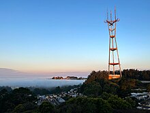
On a clear day, the tower can be seen from theEast Baypeak ofMount Diabloand is sometimes the only part of San Francisco seen above the coastalfogwhen it is blown inland, typically on summer mornings and evenings.
Stations
[edit]Television
[edit]TV stations that transmit from Sutro Tower include the following. Most of these stations carry additionalsubchannelson their frequencies. Subchannel affiliations are shown via the digital channels link.[14][15]
| Callsign | Virtual channel | Physical channel | Affiliation | Digital channels | Online? |
|---|---|---|---|---|---|
| KTVU | 2 | 26 | Fox | 2.1–2.4 | ✔︎ |
| KURK-LD | 3 26 |
3 | REL | 3.1-3.10 26.2 |
✘ |
| KRON-TV | 4 | 7 | The CW | 4.1–4.5 | ✔︎ |
| KPIX | 5 | 29 | CBS | 5.1–5.4 | ✔︎ |
| KGO-TV | 7 | 12 | ABC | 7.1–7.3 | ✔︎ |
| KQED KQEH |
9
54 |
30 | PBS | 9.1–9.4 54.1-54.4 |
✔︎ |
| KQSL-LD | 17 26 |
4 | REL | 17.1-17.10 26.2 |
✘ |
| KRCB | 22 | 5 | PBS | 22.1-22.3 | ✔︎ |
| KCNS KTNC-TV KEMO-TV |
38 42 50 |
32 | Shop LC(KCNS) TCT(KTNC) ShopHQ(KEMO) |
38.1–38.6 42.1-42.2 50.1-50.3 |
✔︎ |
| KPYX | 44 | 28 | Independent | 44.1-44.5 | ✔︎ |
| KQTA-LD KAAP-LD KTSF KMMC-LD KDTS-LD |
15 24 26 30 52 |
14 | JTV Diya TV Ind. (KTSF) Estrella TV Daystar |
15.1-15.10 24.1, 24.4, 24.5, 24.7 26.11 30.1, 30.2 52.1, 52.2 |
✔︎ |
| KPJK | 60 | 27 | Public Ind. | 60.1–60.6 | ✔︎ |
| KFSF | 66 | 34 | UniMás | 66.1–66.5 | ✔︎ |
Radio
[edit]FM stations that transmit from Sutro Tower includeKEXC (Formerly KREV)(92.7),KOIT(96.5),KSOL(98.9),KOSF(103.7), andKNBR-FM(104.5).[16][17]
See also
[edit]References
[edit]- ^Sutro Environmental Impact Report(Report). Federal Communications Commission. July 6, 1997.RetrievedJune 18,2015.
- ^"Furman L. Anderson, Jr., 87, member of North Trenholm Baptist Church who helped design the tallest tower in history in the 1960s".Cola Daily.June 5, 2014.RetrievedJune 18,2015.
- ^"Emporis building ID 118751".Emporis.Archived from the original on March 7, 2016.
{{cite web}}:CS1 maint: unfit URL (link) - ^"Sutro Tower".SkyscraperPage.
- ^Sutro ToweratStructurae
- ^"Sutro Tower History".Sutro Tower.Archivedfrom the original on July 21, 2024.RetrievedJune 22,2024.
- ^Rafkin, Louise (October 8, 2011)."Sutro Tower".The New York Times.RetrievedJune 18,2015.
- ^Hartlaub, Peter (May 28, 2012)."Stature of Sutro Tower rises".San Francisco Chronicle.RetrievedJune 18,2015.
- ^Li, Roland (February 28, 2022)."This is what S.F.'s climate apocalypse could look like, according to hit video game 'Horizon Forbidden West'".San Francisco Chronicle.RetrievedJanuary 14,2023.
- ^Brinklow, Adam (November 18, 2019)."What happened to Sutro Tower's antennae?".Curbed SF.
- ^Rubenstein, Steve (July 14, 2018)."Sutro Tower will sport new antennas — but will still look like 'the big, ugly neighbor'".San Francisco Chronicle.
- ^"Mandatory Discretionary Review Analysis"(PDF).San Francisco Planning Department. July 18, 2019.
- ^"July 2020 Sutro Tower Newsletter"(PDF).Sutro Tower.July 2020.
- ^"About the Tower | Sutro Tower – Official Site".RetrievedJuly 22,2020.
- ^"New Antennas Project"(PDF).Sutro Tower.January 7, 2018. Archived fromthe original(PDF)on March 7, 2020.
- ^"Broadcast Stations".
- ^"A Sutro Signal Boost for KEXP's S.F. Entry | Radio & Television Business Report".December 11, 2023.
Further reading
[edit]- Barnett, Stephen R. (May 1973)."The Colossus of Mt. Sutro".San Francisco.Vol. 15, no. 5.RetrievedSeptember 3,2010.
- Cotter, Mark P. (January 2012)."SUTRO! The High Ground".CreateSpace. Archived fromthe originalon November 26, 2013.
External links
[edit]- Official Site of Sutro Tower, Inc
- "Listing 1001289".Antenna Structure Registration database.U.S.Federal Communications Commission.
- Photos tagged with"sutrotower"atFlickr
- Sutrotower.org,"a comprehensive guide to Sutro Tower and Mount Sutro"
- User page with information about Sutro Tower
- Sutro Tower Community Perspectives
- RCA Broadcast Magazine from 1973 detailing engineering
- Fybush Tower Site of the Week September 23, 2011
- Mak, Alex (June 19, 2014)."A History of Sutro Tower: The Alex Mak Architecture Series".broke-ass stuart.RetrievedJune 18,2015.
- "Sutro Tower: From Eyesore to Icon".exploratorium.August 13, 2014.RetrievedJune 18,2015.
- "Sutro Tower Antenna Omnibus Package"(PDF).Sutro Tower Inc. March 26, 2013.RetrievedJune 18,2015.

