
Tōshijima
Native name: (Đáp chí đảo) | |
|---|---|
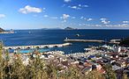
 Tōshijima fromSugashima | |
 | |
| Geography | |
| Location | Mie Prefecture |
| Coordinates | 34°31′13″N136°52′39.4″E/ 34.52028°N 136.877611°E |
| Area | 6.98 km2(2.69 sq mi) |
| Coastline | 26,300 m (86300 ft) |
| Highest elevation | 167.2 m (548.6 ft) |
| Administration | |
Japan | |
| Demographics | |
| Population | 2,981 (2000) |
| Ethnic groups | Japanese |
Tōshijima(Đáp chí đảo)is an inhabited island located inIse Bayoff the east coast of centralHonshu,Japan. It is administered as part of the city ofTobainMie Prefecture.It is the largest of the outlying islands of Toba.
The name of Tōshijima appears in early documents, such as theMan'yōshūandWamyō Ruijushō,and was a base for pirates led byKuki Yoshitakain theSengoku period.
During theMeiji period,the island was made part of Tōshi District(Đáp chí quận),which became part ofShima Districtfrom 1896. On November 1, 1954, the island became part of the city of Toba. The economy of the island is based oncommercial fishing,aquacultureand tourism.
-
 Port of Momotori
 -
 Port of Wagu
 -
 Port of Tōshi


References[edit]
- Saishin-Nihon-chizu - Atlas of Japan,Imidas Shueisha, Tokyo 1990
External links[edit]
Wikimedia Commons has media related toTōshijima.
| International | |
|---|---|
| National | |
This Mie Prefecture location article is astub.You can help Wikipedia byexpanding it. |