
Tamentfoust
 Tamentfoust port | |
 Shown within Algeria | |
| Alternative name | Rusguniae La Pérouse |
|---|---|
| Location | Algeria |
| Region | Algiers Province |
| Coordinates | 36°45′00″N5°04′00″E/ 36.75°N 5.066667°E |
| Cap Matifou Lighthouse | |
 | |
| Coordinates | 36°48′42.2″N3°14′43.29″E/ 36.811722°N 3.2453583°E |
| Constructed | 1868 |
| Foundation | masonry base |
| Construction | masonry tower |
| Height | 6 metres (20 ft) |
| Shape | quadrangular tower with balcony and light attached to 1-storey keeper’s house[2] |
| Markings | white tower |
| Operator | Office Nationale de Signalisation Maritime |
| Focal height | 74 metres (243 ft)[1] |
| Light source | main power |
| Range | 23 nautical miles (43 km; 26 mi)[1] |
| Characteristic | Fl (3) W 15s.[1] |
Tamentfoust(Arabic:تمنتفوست), theclassicalRusguniaeandcolonialLa Pérouse,is a site in theDar El Beïda DistrictofAlgiersinAlgeria.
Geography[edit]
Tamentfoust lies onCape Matifou,which forms the northeast side of theBay of Algiers.
Names[edit]
The Roman nameRusguniaeis alatinizationof thePunicnameRŠGNY(𐤓𐤔𐤂𐤍𐤉), meaning "FrancolinCape"and referring to nearby Cape Matifou.[3]Ptolemyhellenizedthe name asRhoustónion(Greek:Ῥουστόνιον),[4]and it appears in late sources asRusgume,[5]Rugunie,[6]andRusgimia.[7]
The French nameLa Pérouse(literally "Perugia") honored the naval officer and explorerJean-François de Galaup,who owned an estate of that name.
Tamentfoust is aBerbername for "right side", from the cape's position relative toAlgiers.The present name of the cape, Matifou, is a 14th-centurySpanishapproximation of the Berber name.
History[edit]
Rusguniaewas established as acolonyalong the trade route between theStrait of GibraltarandPhoenicia.It consisted of a small fortress on Cape Matifou.[3]It eventually fell underCarthaginiancontrol, probably during the 6th centuryBC.
After thePunic Wars,the area fell underRomanhegemony andAugustusestablished acolonythere[8][9]for the9th Legionat some point during his reign.[3]
Inlate antiquity,it was part of theVandal Kingdomprior to theByzantinereconquest of Africa.It wasoverrunby theUmayyad Caliphatein the 7th century.
Bordj Tamentfoustor Tamentfoust Castle was built byRamdhan Aghain 1661. It was the site of the official declaration of ajihadagainstFranceon 23 July 1830, in response to theFrench invasionof the country.
Religion[edit]
Rusguniae was aChristianbishopric.It was notionally restored as aCatholictitular seein the 20th century:
List of bishops[edit]
- José Gabriel Anaya y Diez de Bonilla (1967.09.15 – 1976.01.06)
- Paul Zinghtung Grawng (1976.01.24 – 1976.12.09)
- Rigoberto Corredor Bermúdez (1988.02.26 – 1996.11.30)
- Anthony Ireri Mukobo,IMC(1999.12.22 – present)
Ruins[edit]
Alongside the museum atBordj Tamentfoust,the site also has ruins of Roman Rusguniae. Maritime history is represented by the Naval Academy of Tamentfoust, known as the biggest naval academy on the continent. The views from the harbor are also a major attraction for visitors.
Gallery[edit]
-

-
 Mosaic of Rusguniae
 -
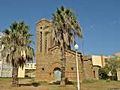 Old church


See also[edit]
References[edit]
Citations[edit]
- ^abcList of Lights,Pub. 113:The West Coasts of Europe and Africa, the Mediterranean Sea, Black Sea and Azovskoye More (Sea of Azov)(PDF).List of Lights.United States National Geospatial-Intelligence Agency.2015.
- ^Rowlett, Russ."Lighthouses of Western Algeria".The Lighthouse Directory.University of North Carolina at Chapel Hill.Retrieved3 May2017.
- ^abcHuss (2006).
- ^Ptol.,Geogr.,Book IV, Ch. ii, §6.
- ^Rav. Cosmogr.,40.43.
- ^Rav. Cosmogr.,88.13.
- ^Guido,Geogr.,132.22.
- ^Plin.,Nat. Hist.,Book V, §20.
- ^Ant. Itin.,16.1.
Bibliography[edit]
- Huss, Werner(2006), "Rusguniae",Brill's New Pauly Encyclopedia of the Ancient World,Leiden: Brill.
External links[edit]
- Blog de Tamentfoust (Association Culturelle de Tmentfoust)
- GCatholic, with titular incumbent biography links


| Algeria |
|
|---|---|
| Cyprus | |
| Greece | |
| Israel | |
| Italy | |
| Lebanon | |
| Libya | |
| Malta | |
| Morocco | |
| Portugal |
|
| Spain | |
| Syria | |
| Tunisia | |
| Other | |
36°48′21″N3°13′48″E/ 36.8058°N 3.2301°E
| Geographic | |
|---|---|
| Cap Matifou Lighthouse |
|