
Tichit
Tichit | |
|---|---|
Communeand village | |
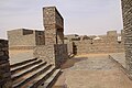
 Tichit, withDhar Tichittescarpment in the background | |
 Tichit Location in Mauritania | |
| Coordinates:18°26′30″N9°29′30″W/ 18.44167°N 9.49167°W | |
| Country | |
| Region | Tagant |
| Official name | Ancient Ksour of Ouadane, Chinguetti, Tichitt and Oualata |
| Type | Cultural |
| Criteria | iii, iv, v |
| Designated | 1996(20thsession) |
| Reference no. | 750 |
| Region | Arab States |
Tichit,orTichitt(Berber languages:Ticit,Arabic:تيشيت), is a village at the foot of theTagant Plateauin central southernMauritaniathat is known for itsvernacular architectureand proximity to theDhar Tichittarchaeological sites. The main agriculture in Tichit isdatefarming, and the village is also home to a smallmuseum.
Tichitt Airporthas two unpaved runways designated in a barren area 1 kilometre (0.62 mi) southeast of the village.
History
[edit]Neolithic
[edit]This region includes a long sandstone cliff formation that defines the northern limit of the Hodh depression, near the former lake ofAoukar.[1]
TheNeolithicsites ofDhar Tichittwere settled around 2000 BC by agropastoral communities known as theTichitt culture.[2]Archaeologists including P.J. Munson, Augustin F.C. Holl, and S. Amblard have found some evidence thatmilletwas farmed there from the date of the communities' foundation. The settlements were generally situated on the cliffs and included stone buildings. They are the oldest surviving archaeological settlements inWest Africaand the oldest stone-built settlements south of the Sahara. They are thought to have been built by the proto-Soninke peopleand were possibly the precursor of theGhana empire.[3][4][5]Hundreds of rock art images have been discovered, depicting various animals and hunting scenes.[6]The area was abandoned around 500 BC probably because of the onset of more arid conditions.
Medieval
[edit]The town of Tichitt was founded in the 12th century as a caravan stop on theTrans-Saharan traderoute linkingOualatatoChinguettiand eventuallySijilmasa.[1]According to legend, seven towns have been built on top of each other at the site.[7]
TheAzer dialectofSoninkewas spoken in Tichit from the era of theWagadou Empireuntil the early 20th century.[8]The name 'Tichit' may be derived from a term meaning 'language of the blacks' in theTuareg languages.[9]
Modern
[edit]The town was self-sufficient and boasted several thousand inhabitants in the early 20th century, but desertification and sand encroachment have led to the abandonment of many structures.[7]In 1996 it was designated a UNESCOWorld Heritage Site.In 1999, torrential rains caused flooding that damaged 80% of the town.[7]
Vernacular Architecture
[edit]-
 The Mosque of Tichitt
 -
 A decorated door in Tichit
 -
 a street in Tichitt
 -
 Open space
 -
 A view of the ancient town of Tichit
 -
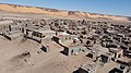 Some modern housing visible in the foreground with many other abandoned historical buildings


Climate
[edit]| Climate data for Tichit | |||||||||||||
|---|---|---|---|---|---|---|---|---|---|---|---|---|---|
| Month | Jan | Feb | Mar | Apr | May | Jun | Jul | Aug | Sep | Oct | Nov | Dec | Year |
| Mean daily maximum °C (°F) | 29.8 (85.6) |
32.9 (91.2) |
37.5 (99.5) |
40.4 (104.7) |
42.5 (108.5) |
42.0 (107.6) |
38.6 (101.5) |
35.8 (96.4) |
37.5 (99.5) |
38.7 (101.7) |
35.3 (95.5) |
31.6 (88.9) |
36.9 (98.4) |
| Mean daily minimum °C (°F) | 16.2 (61.2) |
19.2 (66.6) |
23.8 (74.8) |
26.9 (80.4) |
29.9 (85.8) |
30.5 (86.9) |
28.2 (82.8) |
26.6 (79.9) |
27.0 (80.6) |
27.0 (80.6) |
22.2 (72.0) |
18.1 (64.6) |
24.6 (76.4) |
| Averageprecipitationmm (inches) | 0 (0) |
1 (0.0) |
0 (0) |
1 (0.0) |
1 (0.0) |
6 (0.2) |
15 (0.6) |
32 (1.3) |
19 (0.7) |
3 (0.1) |
1 (0.0) |
0 (0) |
79 (2.9) |
| Source 1:http:// storm247 /weather/110676228/climate(temperature) | |||||||||||||
| Source 2:http:// levoyageur.net/weather-city-TICHITT.html(precipitation) | |||||||||||||
References
[edit]- ^abKjeilen, Tore."TICHIT The living ghost of yesterday's glory".LookLex.Archived fromthe originalon 2020-05-22.
- ^Holl 2009.
- ^Munson 1980.
- ^Fage, J.D (1976),The Cambridge history of Africa, Volume 5,Cambridge: Cambridge University Press, pp. 338, 339,ISBN978-0-521-21592-3.
- ^Coquery-Vidrovitch, Catherine (2005),The History of African Cities South of the Sahara,Princeton: Markus Wiener, pp. 42, 43,ISBN978-1-55876-303-6.
- ^Holl 2002.
- ^abcOuld Ebnou, Moussa (2000)."The Treasures in Mauritania's dunes".The UNESCO Courier.53(12): 26–8.Retrieved13 August2024.
- ^McDougall, E. Ann (1985). "The View from Awdaghust: War, Trade and Social Change in the Southwestern Sahara, from the Eighth to the Fifteenth Century".The Journal of African History.26(1): 1–31.doi:10.1017/S0021853700023069.
- ^Michael J Rueck; Niels Christiansen.Northern Songhay languages in Mali and Niger, a sociolinguistic survey.Summer Institute of Linguistics (1999).
Bibliography
[edit]- Holl, Augustin F.C. (2002),"Time, space, and image making: rock art from the Dhar Tichitt (Mauritania)"(PDF),African Archaeological Review,19(2): 75–118,doi:10.1023/A:1015479826570,hdl:2027.42/43991,JSTOR25130740,S2CID54741966.
- Holl, Augustin F.C. (2009),"Coping with uncertainty: Neolithic life in the Dhar Tichitt-Walata, Mauritania, (ca. 4000–2300 BP)",Comptes Rendus Geoscience,341(8–9): 703–712,doi:10.1016/j.crte.2009.04.005.
- Munson, Patrick J. (1980), "Archaeology and the prehistoric origins of the Ghana Empire",Journal of African History,21(4): 457–466,doi:10.1017/s0021853700018685,JSTOR182004,S2CID161981607.
Further reading
[edit]- Holl, Augustin (1985). "Subsistence patterns of the Neolithic, Mauritania".African Archaeological Review.3:151–162.doi:10.1007/bf01117458.JSTOR25130453.
- Holl, Augustin F.C. (1998). "Livestock husbandry, pastoralisms, and territoriality: the West African record".Journal of Anthropological Archaeology.17(2): 143–165.doi:10.1006/jaar.1998.0321.
- MacDonald, Kevin; Vernet, Robert; Fuller, Dorian; Woodhouse, James (2003)."New light on the Tichitt tradition: A preliminary report on survey and excavation at Dhar Nema"(PDF).Oxford University School of Archaeology Monograph.57:73–80.
External links
[edit]- Map showing Tichit: Fond Typographique 1:200,000,République Islamique de Mauritanie Sheet NE-29-XV
| Cultural | ||
|---|---|---|
| Natural | ||
| Intangible | ||
| International | |
|---|---|
| National | |
| Other | |