
Tughlaqabad Fort
| Tughlaqabad Fort | |
|---|---|
| Part ofDelhi | |
| Delhi,India | |
 Panoramic view of the massive bastions of Tughluqabad Fort | |
| Type | Ruined Fort |
| Site information | |
| Condition | Ruins |
| Site history | |
| Built | 1321 |
| Built by | Ghiyath al-Din Tughluq |
| Materials | GraniteStonesandlime mortar |
Tughluqabad Fortis a ruinedfortinDelhi,India. It was constructed byGhiyasuddin Tughluq,the founder of theTughlaq dynasty,of theDelhi Sultanatein 1321 as he established the third historic city of Delhi, but it was later abandoned in 1327. The fort lends its name to the nearby Tughluqabad residential-commercial area as well as the Tughluqabad Institutional Area. Ghiyasuddin Tughluq also built theQutub-BadarpurRoad, which connected the new city to theGrand Trunk Road.The road is now known asMehrauli-Badarpur Road.[1]The entry fee for the Fort is Rs. 20 for Indians.[2]Also, nearby isDr. Karni Singh Shooting Rangeand Okhla Industrial Area.
Surroundings are an importantbiodiversityarea within theNorthern Aravalli leopard wildlife corridorstretching fromSariska Tiger Reserveto Delhi. Historical places around the sanctuary areBadkhal Lake,6 km (3.7 mi) northeast, the tenth century ancientSurajkundreservoir andAnangpur Dam,Damdama Lake,Tughlaqabad Fort andAdilabad ruins(both in Delhi).[3]It is contiguous to the seasonalwaterfalls in Pali-Dhuaj-Kot villages of Faridabad,[4]the sacredMangar Baniand theAsola Bhatti Wildlife Sanctuary.There are several dozen lakes formed in the abandonedopen pit minesin the forested hilly area of Delhi Ridge.
History
[edit]
Ghazi Malik was afeudatoryof theKhaljirulers of Delhi, India. The Khaliji dynasty is aTurco-Afghan[5]dynasty which ruled India. Once, while on a walk with his Khalji master, Ghazi Malik suggested that the king build aforton a hillock in the southern portion ofDelhi.The king jokingly told Ghazi Malik to build the fort himself when he would become king.[citation needed]
In 1321, Ghazi Malik drove away the Khaljis and assumed the title of Ghias-ud-din Tughlaq, starting theTughlaq dynasty.He immediately started the construction of his fabled city, which he dreamt of as an impregnable, yet beautiful fort to keep away theMongolmarauders. However, destiny would not be as he would have liked.[citation needed]
The Curse of Nizamuddin Auliya
[edit]Ghias-ud-din is usually perceived as a liberal ruler. However, he was so passionate about his dream fort that he issued adictatethat all labourers in Delhi must work on his fort. SaintNizamuddin Auliya,a Sufi saint in the 13th century, got incensed as the work on hisbaoli(well) was stopped. The confrontation between the Sufi saint and the royal emperor has become a legend in India. The saint uttered a curse which was to resonate throughout history until today.[citation needed]
The Death of the ruler
[edit]Another of the saint's curses was "Hunuz Dilli door ast"(Delhi is still far away). The Emperor was engrossed in a campaign inBengalat this time. He was successful and was on his way to Delhi. However, his son,Muhammad bin Tughlaq,met him atKarainUttar Pradesh.Allegedly at the prince's orders, aShamiana(Tent) was made to fall on the Emperor, who was crushed to death (1324).
Mausoleum of Ghiyas ud-Din Tughluq
[edit]
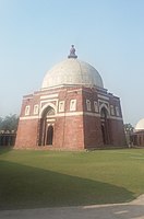
The 'Mausoleum of Ghiyath al-Din Tughluq' is connected by a causeway to the southern outpost of the fortification. This elevated causeway 180 metres (600 ft) in length, supported by 27 arches, leads across a former artificial lake, however sometime in 20th century portion of causeway was pierced by theMehrauli-Badarpurroad.[6]After passing an oldPipal tree,the complex of Ghiyas ud-din Tughluq's tomb is entered by a high gateway made up of redsandstonewith a flight of steps.[7]
The actual mausoleum is made up of a single-domed squaretombabout 8 by 8 metres (26 ft × 26 ft) with sloping walls crowned byparapets.In contrast to the walls of the fortification made up of granite, the sides of the mausoleum are faced by smooth red sandstone and inlaid with inscribed panels and arch borders frommarble.The edifice is topped by an elegantdomeresting on an octagonal drum that is covered with white slabs of marble and slate.[7]

Inside the mausoleum are three graves: The central one belongs toGhiyas ud-din Tughluqand the other two are believed to be those of his wife and his son and successorMuhammad bin Tughluq.In the north-westernbastionof the enclosure wall with its pillared corridors is anotheroctagonaltomb in a similar style with a smaller marble dome and inscribed marble and sandstone slabs over its arched doors. According to aninscriptionover its southern entrance this tomb houses the remains ofZafar Khan.His grave was at the site prior to the construction of the outpost and was consciously integrated into the design of the mausoleum by Ghiyath al-Din himself.[citation needed]

Architecture
[edit]
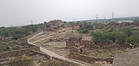
Tughluqabad still consists of remarkable, massive stone fortifications that surround the irregular ground plan of the city. The sloping rubble-filled city walls, a typical feature of monuments of theTughluq dynasty,are between 10 and 15 metres (33 and 49 ft) high, topped by battlementedparapetsand strengthened by circularbastionsof up to two stories height. The city is supposed to once have had as many as 52 gates of which only 13 remain today. The fortified city contained seven rainwater tanks. The fort is a half hexagon in shape with a base of 2.4 km (1.5 mi), and a whole circuit of about 6.4 km (4 mi).[7]
Tughluqabad is divided into three parts:
- the wider city area with houses built along a rectangular grid between its gates
- the citadel with a tower at its highest point known asBijai-Mandaland the remains of several halls and a long underground passage
- the adjacent palace area containing the royal residences. A long underground passage below the tower still remains.


Today most of the city is inaccessible due to dense thorny vegetation. An ever increasing part of the former city area is occupied by modern settlement, especially in the vicinity of its lakes.
South of Tughlaqabad was a vast artificialwater reservoirwithin the fortified outpost ofGhiyath al-Din Tughluq's Tomb.This well preservedmausoleumremains connected to the fort by an elevated causeway that still stands today.
Visible to the southeast are the remains of theFortress of Adilabad,built years later by Ghiyathu'd-Din's successor, Muhammad Tughluq (1325–1351) which shares the main characteristics of construction with Tughlaqabad fort.[8]
Gallery
[edit]-
 A view of ruined fort of Tughlaqabad during sunset
 -
 Modern settlement activity spreading in the area of the old city just below the citadel
 -
 Ghiyath al-Din Tughluq's tomb as seen from Tughluqabad
 -
 Tughlaqabad massive fort wall
 -
 South gate entry to Tughlaqbad fort
 -
 Entrance of the Mausoleum of Ghiyath al-Din Tughluq
 -
 Tomb of Ghiyasuddin Tughlaq and his son Muhammad Bin Tughlaq
 -
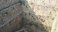 A well inside Tughlaqabad Fort
 -
 Tughlaqabad Fort Architecture


See also
[edit]- Capital forts/palaces in Delhi, oldest first
- Purana Qila,earliest Hindu rulers
- Indraprastha,earlier than 1000 BCE
- Edicts & additions by Ashoka the Great(r. 268 to 232 BCE) of Maurya Empire
- Anangpur,by Anangpal I of Tomara dynasty (r. 736–1152 CE)
- Qila Rai Pithora
- Lal Kot, by Tomara dynasty (1152–1177 CE) as capital
- Qila Rai Pithora, the Lal Kot expended by Prithviraj Chauhan (also called Rai Pithora, r. 1177–92 CE) of Chauhan dynasty
- Siri Fort,by Alauddin Khalji (r. 1296–1316), second ruler of Khalji Dynasty
- Tughlaqabad Fort, by Ghiyassudin Tughluq (r. 1320–25 CE) of Tughluq dynasty
- Feroz Shah Kotla,by Feroz Shah Tughluq (r. 1351–88 CE) of Tughluq dynasty
- Salimgarh Fort,in 1546 CE by Salim Shah Suri (r. 1545–54 CE), son of Sher Shah Suri
- Red fort,built in 1639–48 CE by Mughal emperor Shah Jahan when he moved his capital from Agra to Delhi
- Rashtrapati Bhavan,built in 1912–29 by colonial British raj
- Purana Qila,earliest Hindu rulers
- History of Delhi
References
[edit]- ^Y. D. Sharma (1974). "33. Badarpur".Delhi and its Neighbourhood.Director General, Archaeological Survey of India. p.105.
- ^"Tughlaqabad Fort, Delhi Overview and Info".2 February 2019.Archivedfrom the original on 28 October 2020.Retrieved12 July2020.
- ^Asola Bhatti Wild Life SanctuaryArchived16 August 2011 at theWayback Machine,Department of Forest, Delhi Government
- ^"पाली गांव की पहाड़ियों पर बनेगा डैम, रोका जाएगा झरनों का पानी".Navbharat Times.Archivedfrom the original on 22 July 2019.Retrieved12 July2020.
- ^Khan, Yusuf Husain (1971).Indo-Muslim Polity (Turko-Afghan Period).Indian Institute of Advanced Study.Archivedfrom the original on 10 March 2023.Retrieved6 March2023.
- ^"Modernity pierces fort link".Hindustan Times. 9 September 2012. Archived fromthe originalon 31 October 2013.Retrieved23 September2013.
- ^abcVerma, Amrit (1985).Forts of India.New Delhi: The Director of Publication Division, Ministry of Information and Broadcasting, Government of India. pp. 6–7.ISBN81-230-1002-8.
- ^"Tughlaqabad Fort | Fort Trek".Archivedfrom the original on 27 January 2021.Retrieved23 January2021.