
Tymphe
| Tymphe | |
|---|---|
| Τύμφη | |
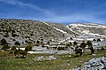
 View of the west face of Mount Tymphe during summer | |
| Highest point | |
| Elevation | 2,497 m (8,192 ft)[1] |
| Prominence | 1,266 m (4,154 ft)[2] |
| Coordinates | 39°58′54″N20°48′54″E/ 39.98167°N 20.81500°E[3] |
| Geography | |
 Tymphe Location within Epirus region, Greece | |
| Location | Ioannina regional unit,Epirus,Greece |
| Parent range | Pindus |
| Topo map | HMGSTsepelovo; Anávasi Topo 50 Pindus Zagori |
| Geology | |
| Age of rock | Palaeocene-Eocene |
| Mountain type | Fold mountain |
| Climbing | |
| First ascent | unknown; first recordedclimbing:1956 |
| Easiest route | walk |
Tymphe(in Latin and English usage) orTymfi(in the Greek government's preferred transliteration),Timfi,alsoTymphi(Greek:Τύμφη,[ˈtimfi]) is amountainin the northernPindusmountain range, in northwesternGreece.It is part of theregional unitofIoanninaand lies in the region ofZagori,just a few metres south of the 40°parallel.Tymphe forms amassifwith its highest peak, Gamila, at 2,497 m (8,192 ft).
The massif of Tymphe includes in its southern part theVikos Gorge,while they both form part of theVikos–Aoös National Parkwhich accepts over 100,000 visitors per year.[4]The former municipality ofTymfiowed its name to the mountain.
Etymology
[edit]The exact meaning of the name is not known but has been in use since ancient times. The name "Tymphe" or "Stymphe" is mentioned by ancient geographerStrabo,Book 7, Ch. 7, and is associated with the ancient land ofTymphaeaand the Tymphaeans, one of the tribes ofAncient Epirus.[5]Despite its ancient use, the name does not appear in any descriptions of the area by Greek or foreign geographers of the 19th century. In du Bocage's map of the region, made in 1820, the mountain is referred to as "Paleo-Vouni" (Greek for Old-Mountain) and Pouqueville mentions the name "Lazaris" in 1826.[6]
The etymology of the mountain's peaks are mainly of Greek origin. The highest peak Gamíla (Γκαμήλα,[gaˈmila]) meanscamelin Greek;[7]Karterós (Καρτερός,[karteros]) means mighty or powerful;[8]Megála Lithária (Μεγάλα Λιθάρια,[meˈɣalaliˈθarja]) means big rocks in modern Greek; Astráka (Αστράκα,[astraka]) is a Greek word for a roof'seavesderived from Slavic стреха; Lápato (Λάπατο,[lapato]) is the Greek word forsorrel;the name for the mountain's third highest peak Goúra (Γκούρα,[gura]) is from a common modern Greek word derived from the Latin gula also related toAromaniangură: a mountain spring; Tsoúka Róssa (Τσούκα Ρόσσα,[ˈt͡sukaˈrosa]) means "red peak" inAromanian.[citation needed]
Geography
[edit]The mountain is surrounded by various massifs that also form part of the northernPindusmountain range. Northeast of Tymphe lies the highest mountain of Pindus,Smolikas.The mountain ofTrapezitsalies to the north,Lyngosto the east andMitsikelito the south. TheAoosriver flows to the north of Mt Tymphe while itstributaryVoidomatishas its sources in the mountain.Vikos Gorgeis formed by the Voidomatis on the southwestern side of the mountain. The length of the mountain is approximately 20 to 25 km with a direction from east to west and its width is approximately 15 km from north to south. The southern and southeastern slopes of the mountain are comparatively smooth. The north side, however, forms cliffs reaching 400 m (1,312 ft), whereas the western side is equally steep since the mountain is fragmented byVikos Gorge.
The massif includes several peaks that stand above 2400m. From west to east the most prominent are the following: Astraka, 2,436 m (7,992 ft), Ploskos, 2,377 m (7,799 ft), Gamila, 2,497 m (8,192 ft), Gamila ΙΙ, 2,480 m (8,136 ft), Karteros, 2,478 m (8,130 ft), Megala Litharia, 2,467 m (8,094 ft), Tsouka Rossa, 2,379 m (7,805 ft), and Goura, 2,466 m (8,091 ft).[9]The peaks form a plateau. Astraka, dominates the plateau on its northern face. Amountain hutnamed D. Georgoulis, which operates during the summer months, is located at the mountain pass between the peaks of Astraka and Lapatos at 1930m of altitude.[10]There are several lakes on the mountain, some of which dry out during the summer. The most famous of those that have water year-round isDrakolimni(lit. "Dragon lake" in Greek), formed after the retreat of theglaciers.[11]It is located at a height of 2,000 m (6,562 ft) northwest of Ploskos. Its maximum depth is 4.95 m (16 ft), while its surface covers 1 ha (2 acres).[12]

Geology
[edit]Mount Tymphe represents a series of uplifted fault blocks and faultedescarpmentsand is largely composed ofPalaeocene-Eocenelimestone, with some exposures ofCampanian-Jurassicdolomite and limestone on the northern scarp. The lower slopes are dominated by youngerflyschrocks, which consist of thin beds of graded sandstones intercalated with softer, fissilesiltstones.[13]Extended glacial conditions prevailed on the uplands of Mount Tymphe during theLate Quaternaryperiod, ca. 28,000 years ago.[14]The glacial landscape is well-developed, especially on the southern slopes of Mount Tymphe, across the Astraka-Gamila plateau, and in the upland terrain above the villages ofSkamneliandTsepelovo,where lateral and terminalmorainesform major landscape features.[15]Additional forms of glacial deposits, which extend down to 850 m (2,789 ft) above sea level,[16]includerock glaciersandlimestone pavements.[17]

A number ofvertical cavesand precipices are found in the area around the village ofPapingo,in the vicinity of the Gamila and Astraka peaks. Some of them have been given names inspired frommythology,such as theHole ofOdysseusandChasm ofEpos.They are being studied and explored by caving enthusiasts. The cave of "Provatina" (Lit. "Ewe's Cave" ), with a depth of 408 m (1,339 ft), one of the deepest in the world, was first discovered in 1965 by Britishspeleologistsof theCambridge University Caving Club,and has since then been surveyed by a large number of expeditions. The nearbyChasm of Epos,with a depth of 451 m (1,480 ft), drains the water coming from the surrounding plateaus.[18]
Climate
[edit]There is no meteorological station at the mountain itself and the closest one is located at the village ofPapingo.The overall climate of theVikos–Aoös National Parkwhich includes the mountain isMediterranean,transitioning tocontinental.The Mediterranean character is characterized by the annual distribution ofprecipitation,high in the winter months and experiencing adroughtperiod of two to three months in summer. The continental climatic element is attributed to the high amplitude of annual temperature variation, to such a degree that the difference between mean maximum and mean minimum annual temperature, exceeds 40 °C (104 °F).[19]Extremely low temperatures occur in the area during the winter months. Compared to Mediterranean bioclimatic divisions, the area belongs to thehumid zonewith cold winters.[19][20]Conditions in the mountain might be significantly different from those of lower regions in the same area. Winters are particularly harsh and the mountain is covered in snow from autumn until late May.
Αccess
[edit]The mountain is located at theZagoriregion and the nearest settlements are mainly villages.Iliochori,VrysochoriandLaistalie to the east,SkamneliandTsepelovoto the south, andPapingoandVikosto the west and southwest respectively.[21]Facilities in the aforementioned villages vary, but most of them offer restaurants and accommodation. The nearest town isKonitsato the northwest. The closest city with an airport isIoannina,approximately 60 km south ofPapingo.The coach service fromIoanninaoffers seven daily coaches toKonitsaand two weekly services toPapingo(on Fridays) as of 2011.[22]TheGR-20(Kozani-Siatista-Ioannina) passes close to the western, northwestern and north sides of the mountain.
Wildlife
[edit]Most of the mountain, with the exception of its southernmost part around the peak of Astraka, forms part of theVikos–Aoös National Park.The park is a designatedprotected areaand visitors should be aware of the limitations to activities imposed by the law. TheWorld Wide Fund for Nature (WWF)runs an information centre in the village ofPapingo.[23]
Tymphe holds the largest recorded population of the Balkanchamoisgoat (Rupicapra rupicapra balcanica) in Greece, with a population between 120-130 individuals out of an estimated national population between 477–750.[24]Although chamois is registered asleast concerninIUCN's red list, the subspeciesbalcanicanumbers some thousands of individuals and its population is believed to be declining.[25]According to theHellenic Ornithological Societymount Tymphe along with the neighbouring mountainSmolikasare important regions for breeding birds of prey, alpine and forest dwelling bird species. TheEgyptian vulture,short-toed snake eagle,rufous-tailed rock-thrushbreed in the region, whereas species such as thegolden eagle,red-billed chough,rock partridge,alpine chough,wallcreeper,white-winged snowfinchand thealpine accentorare sedentary.[26]Alpine reptilian and amphibian species are also present.Vipera ursiniilives in the mountain's subalpine meadows and is considered a threatened taxon.[27]The amphibianalpine newts(Triturus alpestris), living in the alpine lakes of the mountain, mostly in and around Drakolimni, are associated with local folktales of dragons and dragon battles.[28]Yellow-bellied toads(Bombina variegata) are also common in that same area.[12]
Ascent routes
[edit]The simplest and most commonly used route of ascent is the one beginning at the village ofMikro Papingo,located at the western side of the mountain at an altitude of 980 m (3,215 ft). The trail that leads to the Astrakamountain hut,is approximately 6 km long. It is part of the Greek national trail O3 and is generally well marked with signs (red diamond on white) and red dots and arrows on rocks and tree trunks. From the hut, the hikers might either head northeast to thedrakolimnialpine lake for another 2.8 km or southeast to reach Gamila peak, which is the highest peak of the mountain at 2,497 m (8,192 ft) for another 6 km.[29]In both cases there are no signposts and the hikers should solely rely on red dots marked on rocks or scarce small signs attached to wooden poles. The hike from Papingo to the hut lasts between 2–3 hours and the round-trip from the hut to drakolimni another 2 hours.[30]
The mountain is also accessible from other surrounding villages but the trails are longer and the terrain rougher and steeper. Therefore, they are suggested for more experienced hikers. From the village ofVrysochoriat the eastern side of the mountain, a trail of 12.8 km leads to Gamila peak through the Karteros Pass. From the village ofVradetoto the south of the mountain the trail to the peak is approximately 14.9 km. Trails that lead to the mountain can also be followed fromKonitsaandTsepelovo.Those routes are poorly and scarcely marked, mostly by dots of red paint on rocks, and are in some cases unclear and covered by vegetation.
Climbing
[edit]
The first recorded climb of the mountain was made on 7–8 June 1956 by Giorgos Michailidis and Giorgos Xanthopoulos who climbed the face of Gamila. Four years later, on 25–26 August 1960, Guido Magnone and Spyros Antypas climbed the northeastern face of Gamila.[31]Currently there are 17 climbing fields on the mountain, covering most of the major peaks and other geological features of the mountain.[32]From the aforementioned fields, the northeastern face of Gamila counts 8 climbing routes,[33]and Gamila II 6.[34]The fields of Astraka and Tsouka Rossa have several climbing routes each. The former counts 30 routes in both its northwestern and northeastern faces, and the latter 19 routes.[35][36]Potential climbers should take into account that several of the routes were first ascended several years ago and thuspitonsmight be compromised if present at all. Furthermore, some locations in the mountain are isolated and rescue services might find it particularly challenging to access the area in case of emergency.[31]
Gallery
[edit]-
 Αerial photography of Mt. Tymphe
 -
 Horse in the snowy landscape of Mt. Tymphe
 -
 Horses in the snowy landscape of Mt. Tymphe
 -
 Snowy landscape of Mt. Tymphe
 -
 Snowy landscape of Mt. Tymphe
 -
 Landscape of Mt. Tymphe
 -
 Mt. Tymphe (Gamila peak)


See also
[edit]References
[edit]- ^Salmon, Tim; Cullen, Michael (2006).The Mountains of Greece: Trekking in the Pindhos Mountains(2nd ed.). Cicerone. p. 209.ISBN978-1-85284-440-0.
- ^Prominence is calculated fromPetter Bjørstad's site,after correcting the height of Gamila to 2497m instead of the 2481m erroneously mentioned in the site
- ^Data fromGeographic.org
- ^Papadopoulou 2008, p. 20
- ^Smith, William."Dictionary of Greek and Roman Geography (1854)".Retrieved29 May2011.
- ^Χαρίσης, Χαράλαμπος (2022-01-01).Τύμφη και Πάπιγκο: μία αναθεώρηση και μία ετυμολογία[Tymfi and Papingo: a revision and etymology].Academia(in Greek).RetrievedNovember 21,2022.
- ^"γκαμήλα - Ancient Greek (LSJ)".lsj.gr.Retrieved2022-11-24.
- ^"Henry George Liddell, Robert Scott, A Greek-English Lexicon, καρτερός".perseus.tufts.edu.Retrieved2022-11-24.
- ^Information received fromepirus-history.grArchived2011-02-16 at theWayback Machine(in Greek). Retrieved, 26 April 2011
- ^"Αρχική".
- ^Paschos, Nikolaou, Papanikos 2004, p. 15
- ^abDenoël, Mathieu; Schabetsberger, Robert (2003). "Resource partitioning in two heterochronic populations of Greek Alpine newts, Triturus alpestris veluchiensis".Acta Oecologica.24:55–64.doi:10.1016/S1146-609X(03)00043-2.hdl:2268/3029.
- ^Hughes, Gibbard, Woodward 2003, p. 2
- ^Amanatidou, 2005, p. 32
- ^Woodward, Hamlin, Macklin, Hughes, Lewin 2008, p. 8
- ^Hughes, Gibbard, Woodward 2003, p. 3
- ^Woodward, Hamlin, Macklin, Hughes, Lewin 2008, p. 49
- ^Paschos, Nikolaou, Papanikos 2004, p. 16
- ^abAmanatidou 2005, pp. 23–24
- ^"Papingo meteorological station, 1971-1990 climatic data".Hellenic National Meteorological Service. Archived fromthe originalon 2010-11-23.Retrieved2010-11-13.
- ^"Khẩu コミで bình phán をチェック! Tốt đẹp cạnh mã dư tưởng サイト の thăm し phương /Horse Racing".
- ^KTEL Ioaninon.Papingo is searched as "PAPIGO" in the service's engine
- ^The relevant page in the website of WWF (accessed 30 May 2011)http:// wwf.gr/en/index.php?option=com_content&view=category&layout=blog&id=99&Itemid=120Archived2011-07-09 at theWayback Machine
- ^Papaioannou, Haritakis I.; Kati, Vasiliki I (January 2007). "Current status of the Balkan chamois (Rupicapra rupicapra balcanica) in Greece: Implications for conservation".Belgian Journal of Zoology.137(1): 33–39.
- ^Anderwald, P.; Ambarli, H.; Avramov, S.; Ciach, M.; Corlatti, L.; Farkas, A.; Jovanovic, M.; Papaioannou, H.; Peters, W.; Sarasa, M.; Šprem, N.; Weinberg, P.; Willisch, C. (2021)."Rupicapra rupicapra".IUCN Red List of Threatened Species.2021:e.T39255A195863093.doi:10.2305/IUCN.UK.2021-1.RLTS.T39255A195863093.en.Retrieved12 November2021.
- ^"gr066 όρος τύμφη (γκαμήλα) και όρος σμόλικας (in Greek)".Hellenic Ornithological Society.Retrieved30 May2011.
- ^Natura 9
- ^Jackson Jack (2003).The world's great adventure treks.New Holland Publishers. p. 114.ISBN978-1-84330-261-2.
- ^Distances are mentioned as calculated byhellaspath.gr.Although the site is in Greek, the maps and GPS data offered might still be of use to non-Greek users
- ^Salmon, Tim; Cullen, Michael (2006).The Mountains of Greece: Trekking in the Pindhos Mountains(2nd ed.). Cicerone. p. 220.ISBN978-1-85284-440-0.
- ^abRoutes.gr."Tymfi".Routes.gr - D. Mavropoulos.Retrieved3 June2011.
- ^Routes.gr."Climbing Areas: Tymphe".Routes.gr - D. Mavropoulos.Retrieved3 June2011.
- ^Routes.gr."Tymphe - Gamila I".Routes.gr - D. Mavropoulos.Retrieved3 June2011.
- ^Routes.gr."Tymphe - Gamila II".Routes.gr - D. Mavropoulos.Retrieved3 June2011.
- ^routes.gr."Tymphe - Tsouka Rossa".Routes.gr - D. Mavropoulos.Retrieved3 June2011.
- ^routes.gr."Tymphe - Astraka".Routes.gr - D. Mavropoulos.Retrieved3 June2011.
Bibliography
[edit]- Amanatidou, Despoina (2005)."A case study in Vikos-Aoos National Park - Greece"(PDF).University of Freiburg.Retrieved2011-05-27.
- Denoël, Mathieu; Schabetsberger, Robert (2003). "Resource partitioning in two heterochronic populations of Greek Alpine newts, Triturus alpestris veluchiensis".Acta Oecologica.24:55–64.doi:10.1016/S1146-609X(03)00043-2.hdl:2268/3029.
- Hughes, P.D.; Gibbard, P.L.; Woodward, J.C. (2003)."Relict rock glaciers as indicators of Mediterranean palaeoclimate during the Last Glacial Maximum (Late Wurmian) in northwest Greece"(PDF).Journal of Quaternary Science.18(5): 431–440.doi:10.1002/jqs.764.
- "Natura 2000 Data Form. Site code: GR2130009"(PDF).NATURA 2000.Greek Ministry for the Environment, Physical Planning & Public Works. 2009. Archived fromthe original(PDF)on 2011-07-16.Retrieved2010-07-12.
- Papadopoulou, Varvara (2008)."Prefecture of Ioannina, Epirus-Greece"(PDF).Prefectural Committee of Tourist Promotion.Archived fromthe original(PDF)on November 28, 2006.Retrieved2009-11-02.
- Paschos, P.; Nikolaou, E.; Papanikos, D. (2004).Explore the landscape, the rocks and the nature of Vikos-Aoos and surrounding area. Find out its history and civilisation(PDF).Greek Institute of Geology & Mineral Exploration.ISBN978-960-98903-5-9.Archived fromthe original(PDF)on 2011-07-21.
- Salmon, Tim; Cullen, Michael (2006)."chapter 6".The Mountains of Greece: Trekking in the Pindhos Mountains(2nd ed.). Cicerone.ISBN978-1-85284-440-0.Retrieved26 April2011.
- Woodward, J.C.; Hamlin, R.H.B.; Macklin, M.G.; Hughes, P.D.; Lewin, J. (2008)."Glacial activity and catchment dynamics in northwest Greece: Long-term river behaviour and the slackwater sediment record for the last glacial to interglacial transition".Geomorphology.101(1–2): 44–67.doi:10.1016/j.geomorph.2008.05.018.
External links
[edit]- Map of the mountain from Greek National Tourism Organisation
- Greek Mountain Flora
- Climbing routes on Hellenic mountains
| Authority control databases:Geographic |
|---|