
Unter den Linden

Unter den Linden(German:[ˈʊntɐdeːnˈlɪndn̩],"under thelindentrees ") is aboulevardin the centralMittedistrict ofBerlin,Germany. Running from theSpree Riverto theBrandenburg Gate,it is named after thelinden trees(known as lime in the UK and Ireland, not related to citrus lime) that line the grassed pedestrian mall on the median and the two broadcarriageways.The avenue links numerous Berlinsights,landmarks and rivers for sightseeing.
Overview[edit]

Unter den Linden runs east–west from theBerlin Palace,the former main residence of the royalHouse of Hohenzollern,reconstructed (after the demolition of the communistPalace of the Republic) on its old site opposite theLustgartenpark, toPariser PlatzandBrandenburg Gate.Major north–south streets crossingUnter den LindenareFriedrichstraßeandWilhelmstrasse,both meeting atMehringplatzand running across theFriedrichstadt,a city expansion founded in 1691.
Eastward the boulevard crosses theSpreeriver, slightly kinked due to the oblique position of the long side of the palace compared to the boulevard, at the Lustgarten withBerlin Cathedral,and continues asKarl-Liebknecht-Straße,itself continued asPrenzlauer Allee,to the northern outskirts. The western, dead straight continuation behind Brandenburg Gate is theStraße des 17. Juni(formerlyCharlottenburger Chaussee), which in turn is extended to the west by the straight sequence of Bismarckstrasse andKaiserdamm,an axis, widened in 1904, that runs from Berlin Palace more than 10 kilometers across the city to the western outskirts where, slightly elevated, one can survey the length of the axis. The extension of theLindenalley to this gigantic axis was inspired by theBoulevards of Paris.TheKurfürstendamm,the magnificent shopping mile in the historically elegant west of Berlin, was similarly inspired.

Unter den Linden, which sits at the heart of the historic section of Berlin, developed from a bridle path laid out by ElectorJohn George of Brandenburgin the 16th century to reach his hunting grounds in theTiergartenfrom his palace. It was replaced by a boulevard of linden trees when the ElectressDorothea Sophieplanned a new suburb in 1674, named after herDorotheenstadt.She is said to have planted the first linden tree in 1680. Parts of the fortification of Berlin built in the aftermath of theThirty Years' War(the baroqueBerlin Fortress) were later integrated into the boulevard, around the historicOpernplatz,the present-dayBebelplatz,visible until today as there are no trees on this stretch up to the palace on the Spree river island itself. Bebelplatz itself was planned byFrederick the Greatas a much largerForum Fridericianum,albeit on a smaller scale actually realized with hisState Opera,St. Hedwig's Cathedral,theOld Library Buildingand thePalace ofPrince Henry,today the main building ofHumboldt University,giving the square an almost complete surround of 18th-century buildings.
By the 19th century, as Berlin grew and expanded to the west, Unter den Linden became the most renowned and grandest street in Berlin. In 1851 the famousequestrian statue of Frederick the Great,designed byChristian Daniel Rauch,was erected on the central strip.Johann Strauss IIIwrote the waltz "Unter den Linden"in 1900. In the course of the building of theNord-Süd-Tunnelfor theBerlin S-Bahnin 1934–35, most of the linden trees were cut down and during the last days ofWorld War IIthe remaining trees were destroyed or cut down for firewood. The present-day linden were replanted in the 1950s.
As the location of the pre-1914 German Foreign Ministry building, "the Under den Linden" was sometimes used as a shorthand for the German government when talking of German foreign policy.
Points of interest[edit]

Since 1937, the numbering of the properties on the street has started at theSchlossbrücke(Palace Bridge), which connects Unter den Linden with the Lustgarten andMuseum Island.The reconstructedAlte Kommandanturis at No. 1, standing opposite theZeughausarsenal, the oldest building on Unter den Linden, built between 1695 and 1706, now the seat of theDeutsches Historisches Museum,No. 2. Buildings along the street include (from east to west) theCrown Prince's Palace(the former palace of theHohenzollerncrown princes), at No. 3, opposite theNeue Wachewar memorial, No. 4,Karl Friedrich Schinkel’s masterpiece built in 1817. Further along, onBebelplatz,theBerlin State Opera,No. 7, colloquially calledLindenoper,St. Hedwig's Cathedraland theAltes Palais,No. 9, (Old Palace, Berlin) a favoriteNeoclassicalresidence ofEmperor Wilhelm I;next, on the north side lies the main building of theHumboldt University,No. 6, and House I of theBerlin State Library,No. 8. At the western end are theRussian Embassy(former Soviet Embassy, Nos. 63-65, theHungarianEmbassy, No. 76, standing at the junction with Wilhelmstrasse, and finally theHotel Adlon,No. 77, at the corner of Pariser Platz, which has been completely rebuilt on the site of the pre-war hotel. Well-known statues ofAlexanderandWilhelm von Humboldtin front of the university as well as of thePrussiangeneralsScharnhorstandBülow,also adorn the street. A street sign carrying the name Unter den Linden dating from before the 1930s was taken away by British forces and can now be seen at theImperial War Museum,London.
Along Unter den Linden[edit]
-
 Berlin Cathedralfrom the RiverSpree
 -
 Unter den Linden at night
 -
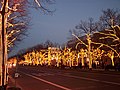 Christmas illumination
 -
 Eastern end atSchlossbrücke(CastleBridge)
 -
-

-
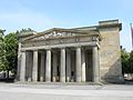 Neue Wache(New Guard House) memorial
 -
-
 Main building ofHumboldt University
 -
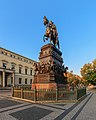 Equestrian statue of Frederick the Great,facing east
 -

-
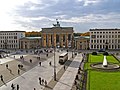 Brandenburg GateatPariser Platz,which marks the western terminus
 -

-
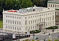
 The reconstructedBerlin Palace


See also[edit]
- Berlin Brandenburger Tor station– formerly Berlin Unter den Linden
- Berlin Unter den Linden station–U-Bahnstation at the Friedrichstraße intersection, served byU5andU6trains.
External links[edit]
- Unter den Linden- Interactive 360° Panorama
- Webcam: Live-View of the street Unter den Linden with Brandenburg Gate in Berlin, Germany

| International | |
|---|---|
| National | |