Uzola
Appearance
| Uzola | |
|---|---|
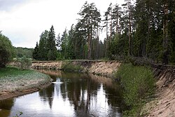
 Steep bank of Uzola | |
| Native name | Узола(Russian) |
| Location | |
| Country | Russia |
| Physical characteristics | |
| Mouth | Volga |
• coordinates | 56°31′15″N43°36′29″E/ 56.5208°N 43.6081°E |
| Length | 147 km (91 mi) |
| Basin size | 1,920 km2(740 sq mi) |
| Basin features | |
| Progression | Volga→Caspian Sea |
TheUzola,also spelled asUsola(Узола, Усола inRussian) is ariverinNizhny Novgorod OblastinRussia.It is a lefttributaryof theVolga.The length of the river is 147 km (91 mi). The area of itsbasinis 1,920 km2(740 sq mi).[1]The Uzola freezes up in November and stays under the ice until April.[citation needed]
References
[edit]- ^«Река Узола (Усола)»,Russian State Water Registry

