
Valley of Elah

TheValley of Elah,Ella Valley( "the valley of theterebinth";[1]from theHebrew:עמק האלהEmek HaElah), orWadi es-Sunt(Arabic:وادي السنط), is a long, shallow valley in theShephelaharea of Israel, best known from theHebrew Bibleas the place whereDaviddefeatedGoliath(1 Samuel 17:2;1 Samuel 17:19). It is home to several important archaeological sites, including those identified as the ancient towns ofAzekahandSocho(1 Samuel 17:1). Rising up from the valley on its extreme southeast end lies the hilltop ruinAdullam,and on its north lie the ruins of the ancient fortress city ofKhirbet Qeiyafa,which is identified with the ancient town of Sha'araim (1 Samuel 17:52).
The valley is named after its indigenous trees - in Hebrew after the large and shadyterebinthtrees (Pistacia atlantica,elah), and in Arabic after the white acacia trees (Acacia albida,sunt). On the west side of the valley, near Socho, there is a very large and ancient terebinth tree, 55 feet (17 m) in height with a trunk 17 feet (5.2 m) in circumference and a canopy at least 75 feet (23 m) in diameter. This tree is notable for being one of the largest terebinths in the area, and marks the upper end of the valley.

Since the early 1970s, the valley has also contained a largesatelliterelay station,with anantenna farmcontaining some 120satellite dishesof various sizes. From 2010 to 2014, the region around the valley was believed to be threatened byshale oil extraction through the CCR ground-heating process,with theGreen Zionist Allianceand the grassroots groupSave Adullam,among others, working to stop exploitation of the region.[2][3][4]The plan was ultimately blocked in 2014 bya zoning committee decision.In July 2019, the Elah Valley came under theIsrael Nature and Parks Authority,owing largely to its historical importance and the desire to curtail the encroaching city limits ofBeit Shemeshto its north.[5]
History
[edit]In 2009, ProfessorYosef Garfinkeldiscovered a fortified city from theIron Age IIdated sometime between 1050 and 915 BC atKhirbet Qeiyafa,southwest ofJerusalemin the Elah Valley.[6]The fortifications have been said to support the biblical account of theUnited Monarchy,the theory that Israel in the time of King David at the beginning of Iron Age II was more than simply a tribal chiefdom.[7]Others are skeptical and suggest it might represent either aJudahiteorCanaanitefortress.[8]


In the late 19th century,Claude ConderandHerbert Kitchenerdescribed the Elah Valley as being "one of the most fertile districts in Palestine. It is an open flat vale about half a mile across, and covered with corn; a narrow trench runs down the center full of white pebbles worn by the water in winter. Here and there largeterebinthsgrow along its course (Butmet Wâdy es Sûr), and solitaryoak trees(Ballûtet Kŭssis). On either side rise the stony hills covered with brushwood and wild growth. "[9]
Flora and fauna
[edit]
Numerous plant species are native to the Elah Valley, including:
- Terebinth (Pistacia terebinthus)
- Kermes oak (Quercus calliprinos)
- Buckthorn (Rhamnus lycioides)
- Carob (Ceratonia siliqua)
- Sweet marjoram (Majorana syriaca;syn.Origanum syriacum)
- Sage (Salvia fruticosa)
- Toothpick (Ammi visnaga)
- Florence fennel (Foeniculum vulgare)
- Anemone (Anemone coronaria)
- Cyclamen (Cyclamen persicum)
- Lupine (Lupinus pilosus)
- Daisy (Glebionis coronaria)
- Syrian cornflower-thistle (Centaurea cyanoides) – rare
- Mallow (Malva nicaeensis)
- Asparagus (Asparagus palaestinus)
- Chicory (Cichorium pumilum;syn.Cichorium endivia)
- Broom lettuce (Lactuca serriola)
- Stinging nettle (Urtica urens)
- Asphodel (Asphodelus aestivus)
- Wild oat (Avena sterilis)
- Wild barley (Hordeum spontaneum;syn.H. ithaburense)
- Wild mustard (Sinapis alba)
- Arum; cuckoo-pint (Arum palaestinum)
- Caper (Capparis spinosa)
- Wild carrot (Daucus carota)
- Globe-thistle (Echinops adenocaulos)
- Ciliate vetchling (Lathyrus blepharicarpus)
- Spiny broom (Calicotome villosa)
- White acacia (Faidherbia albida)


Animal species native to the Elah Valley include:
- Mountain gazelle (Gazella gazella)
- Golden jackal (Canis aureus syriacus)
- Syrian fox (Vulpes thaleb)
- Crested porcupine (Hystrix cristata)
- Egyptian mongoose (Herpestes ichneumon)
- Hedgehog (Erinaceus concolor)
- Middle East blind mole-rat (Spalax ehrenbergi;syn.Nannospalax ehrenbergi)
- Spur-thighed tortoise (Testudo graeca)
- Günther's vole (Microtus guentheri)
- Legless lizard (Pseudopus apodus)
See also
[edit]- Battle of Ajnadayn(634) between Muslim Arabs and Byzantines
- In the Valley of Elah,2007 US film
References
[edit]- ^Elah,Langenscheidt's Hebrew Dictionary,Dr Karl Feyerabend
- ^Krantz, David (1 May 2011)."Israel: The New Saudi Arabia?".Jewcology.
- ^Cheslow, Daniella (18 Dec 2011)."Shale oil project raises hackles in Israel".AFP. Archived fromthe originalon February 5, 2012.
- ^Laylin, Tafline (5 March 2013)."Saudi Turns to Solar, Israel Stuck on Shale".Green Prophet.
- ^Rubin, Yuval, ed. (2019). "The Elah Valley Declared a National Park".Bakitzur - Mateh Yehuda Regional Council and Jerusalem Area(in Hebrew) (509). Tzur Hadassah: Rubin Publishers: 10.(25 July 2019)
- ^“Newly Discovered: A Fortified City from King David’s Time,” Biblical Archaeology Review 35.1 (2009): 38, 40–43.[1]
- ^Govier, Gordon "Archaeology: What an Ancient Hebrew Note Might Mean"Christianity Today1/18/2010[2]
- ^Julia Fridman,'Crying King David: Are the ruins found in Israel really his palace?,'atHaaretz,26 August 2013.
- ^C.R. Conder & H.H. Kitchener,The Survey of Western Palestine,vol. III, London 1883, p. 298
External links
[edit]- 1 Samuel Chapter 17
- The Valley of Elah
- Porcupines, Emperors, and the New Middle East
- Ellah Valley (HD)
Gallery
[edit]-
 Panoramic view of Elah Valley andNeve Michaelas seen from atop MoshavAderet
 -
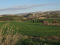 The Valley of Elah, nearAdullam
 -
 Elah Valley as seen from atop ofTel Socho
 -
 View of Elah Valley, looking east from atop of Tel Socho
 -
 Elah Valley, en route to Tel Socho
 -
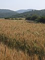 Elah valley in Spring, with ripening grain
 -
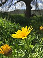 Crown daisy (Glebionis coronaria)
 -
 Pistacia atlantica,from which the valley takes its name
 -
 Beneath the shady boughs of a Persian turpentine tree (Pistacia atlantica) in the Elah valley
 -
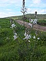 Asphodelin blossom, in the Elah Valley


| International | |
|---|---|
| National | |