
Verdon Gorge
| Verdon Gorge | |
|---|---|
 The Verdon Gorge seen from the Trescaïre viewpoint | |
| Naming | |
| Native name | Gorges du Verdon(French) |
| Geography | |
| Location | Alpes-de-Haute-ProvenceandVar,France |
TheVerdon Gorge(French:Gorges du Verdon) is arivercanyonlocated in theProvence-Alpes-Côte d'Azurregionof SoutheasternFrance.It is about 25 km (15.5 mi) long and up to 700 metres (0.4 mi) deep. It was formed by theVerdon River,which is named for its turquoise-green colour, one of the location's distinguishing characteristics. In between the towns ofCastellaneandMoustiers-Sainte-Marie,the river has cut aravineto a depth of 700 meters through thelimestonemass. At the end of the canyon, the Verdon flows into the artificialLake of Sainte-Croix.
The gorge is very popular with tourists, who can drive around its rim, rentkayaksto travel on the river, orhike.The limestone walls, which are several hundreds of metres high, attract manyrock climbers.It is considered an outstanding destination formulti-pitch climbing,with 1,500 routes available ranging from 20 metres (65 feet) to over 400 metres (1,300 feet).
History
[edit]During theTriassic period,theProvencesubsided and was covered by the sea, leaving thick layers of variouslimestonedeposits. Several million years later, with the arrival of theJurassic period,the area was covered by a warm shallow sea, which allowed the growth of variouscorals.TheCretaceous periodsaw what is nowBasse Provencebeing raised and the sea reaching the current location of the Alps, which were themselves erected during the tertiary era. As a result of the large-scale geological activity, many of the Jurassic limestone deposits fractured, forming relief with valleys and other such features. The origins of the Verdon Gorge can be traced to this era.[citation needed]
The dawn of theQuaternary periodhad large-scaleglaciation,transforming water pockets and lakes into rivers of ice, which remodeled the topography, scouring and striating the landscape.[citation needed]At the end of this activity, erosion by rivers continued, forming the Gorge as it is today.[citation needed]The Verdon's riverbed was scoured for a second time of the accumulated coral and limestone sediments, by a water delivery rate nearing 2000 to 3000 cubic metres per second.[citation needed]
Discovery
[edit]The gorge was described in printed form from 1782 and 1804.[citation needed]By the second half of the 19th century, it was featured in French tourist guides.[citation needed]According toGraham Robb's bookThe Discovery of France,the gorge did not become known outside France until 1906.
Recent developments
[edit]On 10 July 2006, theCouncil of Stateannulled the declaration of public use of a project byEDFrelating to a proposed high-voltage line which would have had to pass through the Verdon Gorge.[citation needed]This decision ended 23 years of struggle by public groups and associations of environmental defence to preserve a site of exceptional natural interest, of which a part contains protected animal and plant species.[1]
During the2022 European drought,the water levels in the river were very low and dried up completely in some parts.[2][3]
Geography
[edit]

The source of the Verdon is close to thecol d'Alloshill in theTrois Evechesmountain range, whence it continues, flowing into theDuranceriver nearVinon-sur-Verdonafter traveling 175 kilometres. BetweenCastellaneand the Galetas bridge, the river passes through thelake of Sainte-Croix,created by the construction of a dam of the same name. Before the dam was constructed, the village ofLes Salles-sur-Verdonoccupied the river plain. To create the reservoir, the village was destroyed in 1973.[citation needed]Les Salles-sur-Verdon was reconstructed as a more modern settlement higher up the valley. Today, it is the youngest village in France.[citation needed]
For some distance the Verdon Gorge forms the border between thedépartementsofVarto the south andAlpes-de-Haute-Provenceto the north in theProvence-Alpes-Côte d'Azurrégion.
This region between Castellane and the Lac de Sainte-Croix is called theGorges du Verdon,or Verdon Gorge. It is split into three distinct parts:
- "Prégorges" ('pre-gorge'), from Castellane to Pont de Soleils,
- the deepest part of the Gorge, from Pont de Soleils to l'Imbut, and
- the Canyon from l’Imbut to the Pont du Galetas.
The Verdon Gorge is narrow and deep, with depths of 250 to 700 metres and widths of 6 to 100 metres at the level of the Verdon river. It is 200 to 1500 metres wide from one side of the Gorge to the other at the summits. The Gorge has been compared to theGrand Canyonin the United States.[4]
Hydro-electric dams
[edit]
Between 1929 and 1975, five dams were erected on the course of the Verdon, between Castellane andGréoux-les-Bains.These dams hold back water in the following reservoirs:
- Lac de Castillon, which was created by flooding the village of the same name
- Lac de Sainte-Croix,flooded the village of des Salles-sur-Verdon.
- Lac d'Esparron-Gréoux, known locally as "lac d’Esparron".
- Reservoir at Chaudanne
- Reservoir at Quinson, sometimes improperly called the "lac de Montpezat", the name of the village over which it dominates.
Notable features
[edit]
The Styx du Verdon, associated with theriver StyxofGreek mythology,is an area of sub-canyon within the gorge.
TheImbut,also known asEmbutorEmbucq,is an area where the Verdon disappears underground, beneath enormous rock structures, before re-emerging above ground.
Tourism
[edit]
The Verdon Gorge attracts numerous tourists, especially during the summer period. The river's turquoise colour is associated withglacialsources and the minerals ofrock floursuspended in the water.[citation needed]
It is easily accessible on its right bank from the north (via route D952 from Castellane to Moustiers-Sainte-Marie), and on its left bank from the south (via routes D71, D90 and D955 fromAiguinestoCastellane).
Sport
[edit]- The Verdon Gorge attracts manyrock climbersfor its more than 1,500 climbing routes on good limestone rock[5]
- The Verdon and its Gorge are also a favoured destination for fishermen, particularly forfly fishing.
- Hiking,canoeing,paragliding,rafting,climbingandcanyoningare some of the sports practised in the region.
Hiking and scenic walks
[edit]The most common hikes in the gorge include:
- Le sentier (pathway) de Martel
- Le sentier de l'Imbut
- Le sentier du Bastidon
- Le belvédère de Rancoumas par le pont de Tusset (the Rancoumas panoramic viewpoint near the Tusset Bridge)
The Sentier Martel, was laid out in 1928 by the Touring Club de France.[citation needed]It was named in 1930 to honor the explorerÉdouard-Alfred Martel(1859–1938).[citation needed]Martel had visited the Verdon in 1905 as an employee of the Southeast Electricity Company, carrying out precise geological surveys of the river. On 11 August, he and his team (explorer Armand Janet, schoolmaster Isidore Blanc, geographer Cuvelier, plaus Baptistin Flory, Fernand Honorat, Prosper Marcel, and Tessier Zurcher)[citation needed]began an expedition of the region.[citation needed]Their successful arrival at the Pas de Galetas marked the completion of the first expedition of the Verdon Canyon.[citation needed]
Other expeditions to the Verdon included Martel's team the following year; followed byRobert de Joly,who in 1928 was the first to completely cross the Verdon Gorge.[citation needed]
Gallery
[edit]-
 The Artuby mixes with the Verdon, at the Mescla
 -
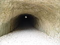 Entrance of Tunnel de Trescaire
 -
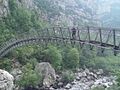 The new footbridge at L'Estellé
 -
 The Échelles Imbert, six stairways and 252 steps
 -
 The Baume-aux-Pigeons


References
[edit]- ^Patriarca, Eliane."Le Verdon sauvé des volts"(in French). libération.fr.Retrieved17 March2007.
- ^"Dried up rivers, dead fish, killer heat: Europe faces worst drought in possibly 500 years - Photos News, Firstpost".12 August 2022.
- ^"Les Gorges du Verdon en manque d'EAU à cause la la sécheresse: Ces impressionnantes images qui effraient".11 August 2022.
- ^Starmer Smith, Charles (8 July 2010)."The Lycra Files: Gorges du Verdon, Provence".The Telegraph.Retrieved10 October2020.
- ^Carne, Alan (10 September 2009)."Gorges Du Verdon".ukclimbing.Retrieved11 August2020.
External links
[edit]| International | |
|---|---|
| Other | |