
Viking 2
 VikingOrbiter | |
| Mission type | Orbiter and Lander |
|---|---|
| Operator | NASA |
| COSPAR ID | |
| SATCATno. |
|
| Website | Viking Project Information |
| Mission duration | Orbiter: 1050 days (1022 sol)[1] Lander: 1316 days (1281 sol)[1] Launch to last contact: 1,676 days |
| Spacecraft properties | |
| Manufacturer | Orbiter:JPL Lander:Martin Marietta |
| Launch mass | 3,530 kg[a] |
| Dry mass | Orbiter: 883 kg (1,947 lb) Lander: 572 kg (1,261 lb)[2] |
| Power | Orbiter: 620 W Lander: 70 W |
| Start of mission | |
| Launch date | 18:39, September 9, 1975 (UTC)[1][3] |
| Rocket | Titan IIIEwithCentaurupper stage |
| Launch site | LC-41,Cape Canaveral |
| End of mission | |
| Last contact | April 12, 1980[4] |
| Orbital parameters | |
| Reference system | Areocentric |
| Marsorbiter | |
| Spacecraft component | Viking 2Orbiter |
| Orbital insertion | August 7, 1976[1][3] |
| Orbital parameters | |
| Periareion altitude | 302 km (188 mi) |
| Apoareion altitude | 33,176 km (20,615 mi) |
| Inclination | 80.5° |
| Marslander | |
| Spacecraft component | Viking 2Lander |
| Landing date | September 3, 1976 22:37:50UTC(MSD36500 00:13AMT)[1] |
| Landing site | 47°38′N225°43′W/ 47.64°N 225.71°W[1] |
TheViking 2mission was part of the AmericanViking programtoMars,and consisted of an orbiter and a lander essentially identical to that of theViking 1mission.[1]Viking 2was operational on Mars for 1281sols(1,316days;3 years, 221 days). TheViking 2lander operated on the surface for 1,316 days, or 1281 sols, and was turned off on April 12, 1980, when its batteries failed. The orbiter worked until July 25, 1978,[1]returning almost 16,000 images in 706 orbits around Mars.[5]
Mission profile[edit]
The craft was launched on September 9, 1975. Following launch using aTitan/Centaurlaunch vehicle and a 333-day cruise to Mars, theViking 2Orbiterbegan returning global images of Mars prior to orbit insertion. The orbiter was inserted into a 1,500 x 33,000 km, 24.6 hMars orbiton August 7, 1976, and trimmed to a 27.3 h site certification orbit with aperiapsisof 1,499 km and an inclination of 55.2 degrees on August 9. The orbiter then began taking photographs of candidate landing sites, which were used to select the final landing site.[6]
The lander separated from the orbiter on September 3, 1976, at 22:37:50UTand landed atUtopia Planitia.[7]The normal procedure called for the structure connecting the orbiter and lander (the bioshield) to be ejected after separation. However, due to problems with the separation process, the bioshield remained attached to the orbiter. The orbit inclination was raised to 75 degrees on September 30, 1976.
Orbiter[edit]
The orbiter's primary mission ended on October 5, 1976, at the beginning ofsolar conjunction.The extended mission commenced on December 14, 1976, after the solar conjunction. On December 20, 1976, the periapsis was lowered to 778 km, and the inclination raised to 80 degrees.
Operations included close approaches toDeimosin October 1977, and the periapsis was lowered to 300 km and the period changed to 24 hours on October 23, 1977. The orbiter developed a leak in its propulsion system that vented itsattitude controlgas. It was placed in a 302 × 33,176 km orbit and turned off on July 25, 1978, after returning almost 16,000 images in about 700–706 orbits around Mars.
Lander[edit]

The lander and itsaeroshellseparated from the orbiter on September 3, 1976, at 19:39:59 UT. At the time of separation, the lander was orbiting at about 4 km/s. After separation, rockets fired to begin landerdeorbit.After a few hours, at about 300 km attitude, the lander was reoriented for entry. The aeroshell with its ablativeheat shieldslowed the craft as it plunged through the atmosphere.

TheViking 2lander touched down about 200 km west of the crater Mie inUtopia Planitiaat48°16′08″N225°59′24″W/ 48.269°N 225.990°Wat an altitude of -4.23 km relative to a reference ellipsoid with an equatorial radius of 3,397.2 km and aflatteningof 0.0105 (47°58′01″N225°44′13″W/ 47.967°N 225.737°Wplanetographic longitude) at 22:58:20 UT (9:49:05 a.m. local Mars time).
Approximately 22 kg (49 lb) of propellants were left at landing. Due to radar misidentification of a rock or highly reflective surface, the thrusters fired an extra time 0.4 seconds before landing, cracking the surface and raising dust. The lander settled down with one leg on a rock, tilted at 8.2 degrees. The cameras began taking images immediately after landing.
TheViking 2lander was powered by radioisotope generators and operated on the surface until its batteries failed on April 12, 1980.
In July 2001, theViking 2lander was renamed theGerald Soffen Memorial StationafterGerald Soffen(1926–2000), the project scientist of theVikingprogram.[6][8]
Results from theViking 2mission[edit]
Landing site soil analysis[edit]
The regolith, referred to often as "soil," resembled those produced from the weathering of basalticlavas.The tested soil contained abundantsiliconandiron,along with significant amounts ofmagnesium,aluminum,sulfur,calcium,andtitanium.Trace elements,strontiumandyttrium,were detected.
The amount ofpotassiumwas one-fifth of the average for the Earth's crust. Some chemicals in the soil contained sulfur andchlorinethat were like those remaining after the evaporation of seawater. Sulfur was more concentrated in the crust on top of the soil than in the bulk soil beneath.
The sulfur may be present assulfatesofsodium,magnesium, calcium, or iron. Asulfideof iron is also possible.[9]TheSpiritroverand theOpportunityroverboth found sulfates on Mars.[10]
Minerals typical weathering products ofmaficigneous rockswere found.[11]All samples heated in thegas chromatograph-mass spectrometer(GCMS) gave off water.
However, the way the samples were handled prohibited an exact measurement of the amount of water. But, it was around 1%.[12]Studies withmagnetsaboard the landers indicated that the soil is between 3 and 7 percent magnetic materials by weight. The magnetic chemicals could bemagnetiteandmaghemite,which could come from the weathering ofbasaltrock.[13][14]Subsequent experiments carried out by the MarsSpiritrover (landed in 2004) suggest that magnetite could explain the magnetic nature of the dust and soil on Mars.[15]

Search for life[edit]
Viking 2carried a biology experiment whose purpose was to look for life. TheViking 2biology experiment weighed 15.5 kg (34 lb) and consisted of three subsystems: thePyrolytic Releaseexperiment (PR), the Labeled Release experiment (LR), and the Gas Exchange experiment (GEX). In addition, independent of the biology experiments,Viking 2carried a Gas Chromatograph/Mass Spectrometer (GCMS) that could measure the composition and abundance of organic compounds in the Martian soil.[16]
The results were Unusual and conflicting: the GCMS and GEX gave negative results, while the PR and LR gave positive results.[17]Viking scientist Patricia Straat stated in 2009, "Our (LR) experiment was a definite positive response for life, but a lot of people have claimed that it was a false positive for a variety of reasons."[18]
Many scientists believe that the data results were attributed to inorganic chemical reactions in the soil. However, this view may be changing due to a variety of discoveries and studies since Viking. These include the discovery of near-surface ice near the Viking landing zone, the possibility of perchlorate destruction of organic matter, and the reanalysis of GCMS data by scientists in 2018.[19]Some scientists still believe the results were due to living reactions. The formal declaration at the time of the mission was that the discovery of organic chemicals was inconclusive.[citation needed]
Mars has almost no ozone layer, unlike the Earth, so UV light sterilizes the surface and produces highly reactive chemicals such as peroxides that would oxidize any organic chemicals.[20]ThePhoenixLanderdiscovered the chemicalperchloratein the Martian soil. Perchlorate is a powerful oxidizing agent, which could have eradicated any organic material on the surface.[21]Perchlorate is now considered widespread on Mars, making it hard to detect any organic compounds on the Martian surface.[22]
Viking 2lander image gallery[edit]


-
 First color image (Viking 2lander Camera 2 sol 2, September 5, 1976) 14:36
 -
 Viking 2lander Camera 2 22G144 (Low Resolution Color) Sol 552 19:16
 -
 Frost on Mars.
 -
 Viking 2lander Camera 2 FROST (Low Resolution Color) Sol 955 12:13
 -
 Frost at the landing site. (false color)
 -
 Viking 2lander Camera 1 FROST (Low Resolution Color) Sol 960 14:14
 -
 Viking 2lander Camera 1 FROST HIGH RESOLUTION (With Low Resolution Color) Sol 959 14:39
 -
 Viking 2lander Camera 2 SKY AT SUNRISE (Low Resolution Color) Sol 34 04:22
 -
 Viking 2lander Camera 2 SKY AT SUNRISE (Low Resolution Color) Sol 631 04:00


Orbiter results[edit]
Viking program[edit]
The Viking Orbiters led to significant discoveries about the presence of water on Mars. Huge river valleys were found in many areas. They showed that water floods carved deep valleys, eroded grooves into bedrock, and traveled thousands of kilometers. In the southern hemisphere, the presence of branched stream areas suggests that there was once rainfall.[23][24][25]
The images below are mosaics of many small, high-resolution images.
-
 Streamlined islands seen by Viking showed that large floods occurred on Mars. Image is located inLunae Palus quadrangle.
 -
 Tear-drop shaped islands caused by flood waters fromMaja Valles,as seen by Viking Orbiter. Image is located inOxia Palus quadrangle.The islands are formed in the ejecta ofLod,Bok,andGoldcraters.
 -
 Scour patterns, located inLunae Palus quadrangle,were produced by flowing water from Maja Valles, which lies just to the left of this mosaic. Detail of flow aroundDromorecrater is shown on the next image.
 -
 Great amounts of water were required to carry out the erosion shown in this Viking image. Image is located inLunae Palus quadrangle.The erosion shaped the ejecta aroundDromore.
 -
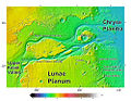
 Waters fromVedra Valles,Maumee Valles,and Maja Valles flowed from Lunae Planum on the left, toChryse Planitiaon the right. Image is located inLunae Palus quadrangleand was taken by Viking Orbiter.
 -
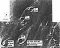
 Area around northern Kasei Valles, showing relationships amongKasei Valles,Bahram Vallis,Vedra Valles,Maumee Valles,andMaja Valles.Map location is inLunae Palus quadrangleand includes parts of Lunae Planum andChryse Planitia.
 -
 The ejecta fromArandascrater acts like mud. It moves around small craters (indicated by arrows), instead of just falling down on them. Craters like this suggest that large amounts of frozen water were melted when the impact crater was produced. Image is located inMare Acidalium quadrangleand was taken by Viking Orbiter.
 -
 This view of the flank ofAlba Paterashows several channels/troughs. Some channels are associated with lava flows; others are probably caused by running water. A large trough or graben turns into a line of collapse pits. Image is located inArcadia quadrangleand was taken by Viking Orbiter.
 -
 Branched channels inThaumasia quadrangle,as seen by Viking Orbiter. Networks of channels like this are strong evidence for rain on Mars in the past.
 -
 The branched channels seen by Viking from orbit strongly suggested that it rained on Mars in the past. Image is located inMargaritifer Sinus quadrangle.
 -
 Ravi Vallis, as seen by Viking Orbiter.Ravi Valliswas probably formed when catastrophic floods came out of the ground to the right (chaotic terrain). Image located inMargaritifer Sinus quadrangle.
 -
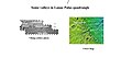
 Deimos,photo taken in 1977.


Location[edit]

 Clickable image:Clicking on the labels will open a new article.
See also[edit]
- Exploration of Mars
- List of missions to Mars
- List of Mars orbiters
- Timeline of artificial satellites and space probes
- U.S. Space Exploration History on U.S. Stamps
Notes[edit]
References[edit]
- ^abcdefghWilliams, David R. (December 18, 2006)."Viking Mission to Mars".NASA.RetrievedFebruary 2,2014.
- ^ab"Viking 2 Lander".National Space Science Data Center.
- ^abNelson, Jon."Viking 2".NASA.RetrievedFebruary 2,2014.
- ^NASA.gov
- ^"Viking 2 Orbiter".National Space Science Data Center.RetrievedAugust 16,2019.
- ^ab"In Depth: Viking 2".NASA Science – Solar System Exporation.NASA.
- ^"Viking 1 and 2, NASA's first Mars landers".The Planetary Society.RetrievedJune 14,2024.
- ^Malik, Tariq (August 22, 2012)."Mars Rover Landing Site Named for Sci-Fi Icon Ray Bradbury".Space.
- ^Clark, B. et al. 1976. Inorganic Analysis of Martian Samples at the Viking Landing Sites. Science: 194. 1283–1288.
- ^Mars Exploration Rover Mission: Press Release Images: Opportunity
- ^Baird, A. et al. 1976.Mineralogic and Petrologic Implications of Viking Geochemical Results From Mars: Interim Report.Science: 194. 1288–1293.
- ^Arvidson, R et al. 1989. The Martian surface as Imaged, Sampled, and Analyzed by the Viking Landers. Reviews of Geophysics:27. 39-60.
- ^Hargraves, R. et al. 1976. Viking Magnetic Properties Investigation: Further Results.Science:194. 1303–1309.
- ^Arvidson, R, A. Binder, and K. Jones. The Surface of Mars.Scientific American
- ^Bertelsen, P. et al. 2004. Magnetic Properties Experiments on the Mars Exploration roverSpiritat Gusev Crater.Science:305. 827–829.
- ^Life on MarsArchivedOctober 20, 2014, at theWayback Machine
- ^Viking Data May Hide New Evidence For Life.Barry E. DiGregorio, July 16, 2000.
- ^Viking 2Likely Came Close to Finding H2O.ArchivedSeptember 30, 2009, at theWayback Machine
- ^Guzman, Melissa; Mckay, Christopher; Quinn, Richard; Szopa, Cyril; Davila, Alfonso; Navarro-Gonzalez, Rafael; Freissinet, Caroline (2018)."Identification of chlorobenzene in the Viking gas chromatograph-mass spectrometer data sets: Reanalysis of Viking mission data consistent with aromatic organic compounds on Mars".Journal of Geophysical Research: Planets.123(7): 1674–1683.Bibcode:2018JGRE..123.1674G.doi:10.1029/2018JE005544.S2CID133854625.
- ^Hartmann, W. 2003. A Traveler's Guide to Mars. Workman Publishing. NY NY.
- ^Alien Rumors Quelled as NASA Announces Phoenix Perchlorate Discovery.ArchivedSeptember 4, 2010, at theWayback MachineA.J.S. Rayl, August 6, 2008.
- ^Chang, Kenneth (October 1, 2013)."Hitting Pay Dirt on Mars".New York Times.RetrievedOctober 10,2013.
- ^Kieffer, Hugh H. (October 1992).Mars: Maps.ISBN978-0-8165-1257-7.
- ^Raeburn, P. 1998. Uncovering the Secrets of the Red Planet Mars. National Geographic Society. Washington D.C.
- ^Moore, P. et al. 1990.The Atlas of the Solar System.Mitchell Beazley Publishers NY, NY.
External links[edit]
- The Viking Mars Missions Education & Preservation Project, VMMEPPonline exhibit.
- Viking 2Mission Profile by NASA's Solar System Exploration
- 45 years ago:Viking1 Touches Down on Mars
| Active |
|    | |||||||||
|---|---|---|---|---|---|---|---|---|---|---|---|
| Past |
| ||||||||||
| |||||||||||
| Future |
| ||||||||||
| |||||||||||
| Exploration |
| ||||||||||
Missions are ordered by launch date. Sign†indicates failure en route or before intended mission data returned. | |||||||||||