
Voer
| Voer Fouron | |
|---|---|
 The Voer in's-Gravenvoeren | |
| Location | |
| Country | Belgium,Netherlands |
| Physical characteristics | |
| Source | |
| • location | nearSint-Pieters-Voeren |
| • coordinates | 50°44′08″N5°49′26″E/ 50.7355°N 5.8238°E |
| Mouth | |
• location | MeuseinEijsden |
• coordinates | 50°46′25″N5°41′51″E/ 50.7735°N 5.6974°E |
| Length | 12 km (7.5 mi) |
| Basin size | 12 km2(4.6 sq mi) |
| Discharge | |
| • average | 1.32 m3/s (47 cu ft/s) |
| Basin features | |
| Progression | Meuse→North Sea |
TheVoer(Dutch,pronounced[vuːr];French:Fouron)[1]is a small river inBelgiumand theNetherlands.It is a right-bank tributary to the riverMeuse.It has three (creek-) tributaries of its own: theVeurs,theNoorand theBeek.
The source of the Voer is near the village ofSint-Pieters-Voerenin the Belgian province ofLimburg.The river crosses the Belgian-Dutch border between's-GravenvoerenandMesch,and flows into the river Meuse atEijsden.The Voer's total length is about 12 kilometres (7.5 mi). It lends its name to theVoerenmunicipality as well as to the villages 's-Gravenvoeren, Sint-Pieters-Voeren andSint-Martens-Voerenthrough which it passes.
-
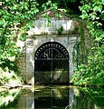 Source (-building) of the Voer at Sint-Pieters-Voeren
 -
-
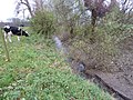
 Estuary of the Voer atEijsden.


References
[edit]
ThisDutch Limburglocation article is astub.You can help Wikipedia byexpanding it. |