
Wallops Flight Facility
 Wallops Flight Facility insignia | |
| Agency overview | |
|---|---|
| Formed | 1945 |
| Preceding agencies |
|
| Headquarters | Wallops Island, Virginia,37°56′25″N75°27′59″W/ 37.940194°N 75.466389°W |
| Employees | 1,400 |
| Agency executive |
|
| Parent agency | Goddard Space Flight Center NASA |
| Website | nasa.gov/centers/wallops |
| Map | |
 Wallops Flight Facility with its three separate parcels of property | |

Wallops Flight Facility(WFF) (IATA:WAL,ICAO:KWAL,FAALID:WAL) is arocket launch siteonWallops Islandon theEastern Shore of Virginia,United States,just east of theDelmarva Peninsulaand approximately 100 miles (160 km) north-northeast ofNorfolk.The facility is operated by theGoddard Space Flight CenterinGreenbelt, Maryland,and primarily serves to support science and exploration missions forNASAand otherFederal agencies.WFF includes an extensively instrumented range to support launches of more than a dozen types ofsounding rockets;[1]small expendable suborbital and orbital rockets;[2]high-altitude balloonflights carrying scientific instruments for atmospheric and astronomical research; and, using its Research Airport,flight testsof aeronautical research aircraft, includingunmanned aerial vehicles.
There have been over 16,000 launches from the rocket testing range at Wallops since its founding in 1945 in the quest for information on the flight characteristics of airplanes, launch vehicles, and spacecraft, and to increase the knowledge of the Earth's upper atmosphere and the environment ofouter space.The launch vehicles vary in size and power from the smallSuper Lokimeteorological rockets to orbital-class vehicles.[3][4][5]
The Wallops Flight Facility also supports science missions for theNational Oceanic and Atmospheric Administration(NOAA) and occasionally for foreign governments and commercial organizations. Wallops also supports development tests and exercises involvingUnited States Navyaircraft and ship-based electronics and weapon systems in theVirginia Capesoperating area, near the entrance to theChesapeake Bay.In addition to its fixed-location instrumentation assets, the WFF range includes mobileradar,telemetryreceivers, and command transmitters that can be transported bycargo planesto locations around the world, in order to establish a temporary range where no other instrumentation exists, to ensure safety, and to collect data in order to enable and support suborbital rocket launches from remote sites.
The WFF mobile range assets have been used to support rocket launches from locations in the Arctic and Antarctic regions,South America,Africa, Europe,Australia,and at sea. Workers at Wallops include approximately 1,000 full-time NASAcivil serviceemployees and the employees of contractors, about 30U.S. Navypersonnel, and about 100 employees of NOAA.
History[edit]
In 1945, NASA's predecessor agency, theNational Advisory Committee for Aeronautics(NACA), established a rocket launch site onWallops Islandunder the direction of theLangley Research Center.This site was designated thePilotless Aircraft Research Stationand conducted high-speed aerodynamic research to supplement wind tunnel and laboratory investigations into the problems of flight. In 1958, Congress established NASA, which absorbed Langley Research Center and other NACA field centers and research facilities. At that time, the Pilotless Aircraft Research Station became a separate facility,Wallops Station,operating directly under NASA Headquarters in Washington, D.C.
In 1959, NASA acquired the formerNaval Air Station Chincoteague,and engineering and administrative activities were moved to this location. In 1974, the Wallops Station was namedWallops Flight Center.The name was changed toWallops Flight Facilityin 1981, when it became part of Goddard Space Flight Center.
In the early years, research at Wallops concentrated on obtaining aerodynamic data at transonic and low supersonic speeds. Between 1959 and 1961, Project Mercury[6]capsules were tested at Wallops in support of NASA's crewed space flight program - theMercury program- before astronauts were launched fromCape Canaveral Air Force Stationin Florida. Some of these tests using theLittle Joebooster rocketwere designed toflight-qualifycomponents of the spacecraft, including the escape and recovery systems and some of the life support systems. Two rhesus monkeys,Samand Miss Sam, were sent aloft as pioneers for astronauts; both were recovered safely.
The first payload launched into orbit from Wallops Island wasExplorer IX,atop aScout rocket,on February 15, 1961.[7]
On September 6, 2013, the Lunar Atmosphere and Dust Environment Explorer (LADEE) was launched from Wallops, atop aMinotaur Vrocket. This was the first time that an American lunar mission had been launched from anywhere butFlorida.[8]
Wallops Island is currently experiencingbeach erosionof 10 to 22 feet (3 to 7 meters) a year, due in part to thecurrent sea level rise;some access roads and parking lots have had to be rebuilt several times over the past five years. NASA has responded by continually fortifying the shoreline with sand.[9]
A permanent ground control station for NASA'sRQ-4 Global Hawkdrone is at Wallops Flight Facility.[10]
Facilities[edit]

The WFF Main Base is located on the Eastern Shore of Virginia on theDelmarva Peninsulaabout 5 miles (8.0 km) west ofChincoteague, Virginia;about 90 miles (140 km) north ofNorfolk, Virginia,and 40 miles (64 km) southeast ofSalisbury, Maryland.The WFF consists of three separate parcels of land totaling 6,200acres(25 km²): the Main Base, the Mainland, and the Wallops Island Launch Site. The Mainland and the Wallops Island Launch Site are about 7 miles (11 km) southeast of the Main Base.
Airspace[edit]
Wallops operatescontrolled airspacewithFederal Aviation Administration(FAA) qualifiedair traffic controllersincluding:
- The WFF Airport Control Zone to 2,500 feet (760 m) within a 5-statute-mile (8.0 km) radius of the airport
- Restricted Area R-6604 connecting WFF airspace and offshore warning areas.
Fixed facilities[edit]
Major Wallops facilities include FAA-certifiedrunways;an experimental UAV runway; and crash, fire, and rescue services. WFF has facilities for the receipt, inspection, assembly, checkout and storage ofrocket motorsand other hazardouspyrotechnic devices.The Wallops Island Launch Site includes sixlaunch pads,threeblockhousesfor launch control, and assembly buildings to support the preparation and launching of suborbital and orbital launch vehicles.

The Wallops Research Range includes ground-based and mobile systems, and a range control center. Its radar facilities and systems are used for tracking and surveillance. Telemetry facilities include a variety of antennas, receivers, and display instrumentation systems. Command uplink and optical tracking facilities are included as part of the range. The range also provides premier digital photographic and video services including operation of numerous still cameras, high speed and video systems for Range Safety support, surveillance, and post-launch analysis (e.g., failure analysis), project documentation (e.g., fabrication and test), administrative documentation, and archiving for environmental studies. In addition, WFF has a variety of communications systems and facilities to route voice, video, and data in support of launch processing, flight, and test operations.
The WFF Research Airport is located on the Main Base. There are three runways (from 4,810 feet (1,470 m) to 8,750 feet (2,670 m) long), twotaxiways,three ramps, and one hazardous cargo loading area in active service. Two ramps adjoin the two active hangars, and a third ramp adjoins the Crash, Fire and Rescue building. The primary research runway has a test section with a variety of surface textures and materials for runway research projects.
Weather measurements and predictions are critical to all Research Airport operations, rocket and balloon launches, and in safely conducting hazardous operations on the ground. Wallops meteorological services provide measurements of upper atmospheric and magnetic phenomena to augment and enable the collection of scientific data by sensors aboard flight vehicles. TheS-bandDoppler radar[11]system at Wallops, known as SPANDAR, is capable of automatic unambiguous tracking of targets up to 60,000 kilometers away. It can detect a single raindrop of 3 millimeters at a range of 10 kilometers and cloud water content as little as 1 gram per cubic meter. SPANDAR's sensitivity with its 60-foot (18 m) dish antenna can detect small changes in therefractive indexof air caused by sea breeze fronts, gust fronts, and various forms ofclear air turbulence.
Mobile systems[edit]

The Wallops mobile range instrumentation includes telemetry, radar, command and power systems. These assets are used as needed to supplement instrumentation at existing ranges, or to establish a temporary range to ensure safety and collect data to support the rocket customers in a remote location where no other range instrumentation exists. This complement of transportable systems can be deployed to provide complete range capabilities at remote locations around the world. While Wallops Island is the prime location for range services, major sounding rocket campaigns have been supported atPoker Flat,Alaska;Andoya,Norway;andKwajaleinIsland,Marshall Islands.The Wallops Mobile Instrumentation is integrated with NASA andDepartment of Defensenetworks and can be used to supplement established ranges in support of rocket launches.
Range technology development[edit]

Since 2001, engineers at NASA Wallops Flight Facility have been developing new range technologies, systems and approaches to improve the cost and responsiveness of launch and flight test activities, within the constraints of available funding and program schedules.
Specifically, NASA Wallops has been leading two range technology development projects: theAutonomous Flight Safety System (AFSS) and the Low Cost TDRSS Transceiver (LCT2).
AFSS is a project to develop an autonomous on-board system that could augment or replace traditional ground-commanded Range Safety flight termination systems. The AFSS would use redundant sensors and processors on board a launch vehicle to monitor its trajectory, and if necessary initiate pyrotechnic devices to terminate the flight.
LCT2 is an effort to produce a relatively low-cost transceiver to allow launch vehicles to communicate through NASA'sTracking and Data Relay Satellite System(TDRSS) after they have gone over the horizon from the launch site. LCT2 is being pursued as part of the Space Based Range Demonstration and Certification (SBRDC) program (formerly calledSpace Based Telemetry and Range Safety (STARS)) in cooperation with NASAKennedy Space Center.
Missions[edit]


WFF's primary mission areas are as follows:
- Sounding Rockets
- Scientific Balloons
- Aircraft
- Range and Mission Management
- Small Launch Vehicle Research
- Mission Planning Lab
With its sounding rocket, aircraft, and balloon flights carrying scientific payloads, its aeronautical systems testing, its range support for Space Shuttle launches, and its educational outreach activities, WFF supports all of NASA's Mission Directorates and practically all of their respective themes:
- Science Mission Directorate
- Exploration Mission Directorate
- Aeronautics Mission Directorate
- Space Operations Mission Directorate
Commercial spaceport[edit]
In 1998, theVirginia Commercial Space Flight Authority,later joined byMaryland,built theMid-Atlantic Regional Spaceportat Wallops on land leased from NASA. In December 2006, the facility made its first launch.[12]
Visitor center[edit]

TheWallops Visitor Centerhas a variety of hands-on exhibits and hosts weekly educational activities and programs to enable children to explore and learn about the technologies designed and used by NASA researchers and scientists. In addition, one Saturday each month, NASA invitesmodel rocketryenthusiasts to launch their own rockets from the WFF rocket launch site. NASA personnel also participate, launching models of various rockets and explaining thespacecraftthey carry in real life.
The schedule for sounding rocket launches from WFF is posted on its official Web site.[13]
Education[edit]
For many years WFF was home to the NSIP Sub-SEM and SEM projects. NSIP stands for the NASA Student Involvement Project, the Sub-SEM project was to design one of four experiments that would be inserted into an ORION-II one-stage rocket and launched above 98 percent of the atmosphere, and experience over 30 Gs of centrifugal force, while SEM was to design an experiment that would be flown on a future Space Shuttle mission. Each project gave 16 students and four teachers (four students and one teacher from each high school) the opportunity to spend an almost all-expense-paid week at WFF. Normally the students and teachers stayed in the Mariner Motel, now a Holiday Inn, conducting experiments and learning about the facility. Following the presidential mandate and budget cuts the entire NSIP program, SEM and Sub-SEM included, was shut down.
Accidents[edit]
On April 2, 1957, aLockheed P2V-6 Neptuneexploded in midair after takeoff from what was then known asNaval Auxiliary Air Station Chincoteague.All eleven occupants of the aircraft died.[14]
On October 23, 1995, the maiden flight of aConestoga 1620 rocketfailed 46 seconds after liftoff, resulting in disintegration.EER Space Systems,Conestoga's manufacturer, concluded that low frequency noise from an unknown source upset the guidance system on the rocket causing it to order course corrections when none were needed. The rocket went off course when its first stage steering mechanism ran out of hydraulic fluid and became inoperable. After this failure, the Conestoga program was terminated, and EER abandoned the launch business.[15][16]At the time of the launch, the Conestoga was the largest rocket ever launched from Wallops Island, and it was the first orbital mission attempted from the facility since 1985.[17]The company'slaunch padat Wallops Island were the first commercially built facilities in the US. 14 scientific experiments, some of which were planned to return from orbit, were destroyed. All debris landed in the Atlantic Ocean. There were no injuries.[18]
On October 27, 1998, aLearjet 45was destroyed at Wallops after a loss of control during a water ingestion test flight. Only minor injuries to a copilot and flight engineer were reported. There were no ground injuries. The airplane was being used to test a new nose wheel tire. For the test, the airplane was passed through a "pool" or "trough" of water on the runway at different speeds.[19]The pilot failed to obtain/maintain alignment with the water pool and lost control. The plane departed the left side of the runway, and struck a pickup truck parked adjacent to the runway.[20]
On August 22, 2008, anALV X-1sounding rocketwas intentionally destroyed 20 seconds into flight after veering too far off course.[21]
On October 28, 2014, a failure occurred in anAntaresrocket, carryingCygnus CRS Orb-3,shortly after launch and destroyed both the rocket and the payload at the adjacentMid-Atlantic Regional SpaceportonLaunch Pad 0A.[22]
Alliances[edit]
The NASA Wallops Flight Facility has alliances with a number of organizations important to its mission and future growth. Some examples include:
- Mid-Atlantic Regional Spaceport (MARS)
- U.S. Navy Surface Combat Systems Center (SCSC)
- Navy Test and Training Ranges
- U.S. Space Force Space Launch Delta 45, Eastern Range
- U.S. Coast Guard
- National Oceanic and Atmospheric Administration (NOAA),National Environmental Satellite, Data, and Information Service (NESDIS)
- Marine Science Consortium (MSC)
- White Sands Missile Range (WSMR)
It has also worked with theNational Security Agencyin experiments involving ionized clouds for communications interception during theCold War.[23]
Image gallery[edit]
-
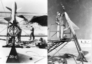 Early research rockets at Wallops Island
 -
 Wallops flight tests of Mercury capsule escape tower and Apollo heat shield aboard a Scout
 -
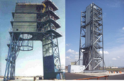
 Mobile Range Systems
 -
 Launch Pads 0-A and 0-B
 -
 Mobile Telemetry System
 -
 Optical Tracking Systems
 -
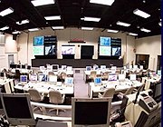 Range Control Center
 -
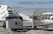 Mobile system at theSvalRaklaunch site at Ny-Ålesund, Norway (2003)


See also[edit]
References[edit]
- ^"Sounding Rocket Vehicles".Nasa Wallops Flight Facility.Retrieved22 April2013.
- ^"Expendable Launch Vehicles".Nasa Wallops Flight Facility.Retrieved22 April2013.
- ^"NFIRE"(PDF).Nasa Wallops Flight Facility. Archived fromthe original(PDF)on 19 February 2013.Retrieved22 April2013.
- ^"Overview".Mid-Atlantic Regional Spaceport. Archived fromthe originalon 4 October 2013.Retrieved22 April2013.
- ^"Activities at Wallops Flight Facility".American Astronautical Society.Retrieved22 April2013.
- ^"Project Mercury Overview".Nasa Kennedy Space Centre. Archived fromthe originalon 3 June 2013.Retrieved22 April2013.
- ^Myler, Joseph L. "7-Mile Salt Marsh, Sand Strip in Virginia Oldest, Tiniest Spaceport in U.S." (March 16, 1961), UPI viaThe Middlesboro Daily News ", p. 3
- ^"NASA Launch Shoots for the Moon from Virginia Tonight: Watch It Online",Space, September 6, 2013
- ^McNeill, Ryan; Nelson, Deborah J. (4 September 2014)."As the seas rise, a slow-motion disaster gnaws at America's shores".reuters.Reuters.Retrieved4 September2014.
- ^3 governors, 1 mission: Bring drones to WallopsRetrieved June 30, 2017.
- ^Philip A. Ingwersen and William Z. Lemnios (2000)."Radars for Ballistic Missile Defense Research"(PDF).Lincoln Laboratory Journal.12(2): 245–266. Archived fromthe original(PDF)on October 25, 2007.Retrieved22 April2013.
- ^"Mid-Atlantic commercial spaceport makes 1st launch".USATODAY. December 16, 2006.Retrieved22 April2013.
- ^"NASA's Wallops Flight Facility".Nasa.Retrieved27 October2014.
- ^"Aircraft accident Learjet 45 N454LJ Wallops Island, VA".aviation-safety.net.Retrieved25 November2018.
- ^"Conestoga 1620".astronautix.Archived fromthe originalon December 9, 2016.Retrieved25 November2018.
- ^"Conestoga".globalsecurity.org.Retrieved25 November2018.
- ^Roylance, Frank."Rocket explodes above Wallops Malfunction ends first commercial flight from NASA center".baltimoresun.Retrieved25 November2018.
- ^Chrasekaran, Rajiv."Rocket explodes off VA".washingtonpost.Retrieved25 November2018.
- ^"NTSB Identification: IAD99FA008".ntsb.gov.Retrieved25 November2018.
- ^"Aircraft accident Lockheed P2V-6 Neptune 126518 Chincoteague NAAS, VA".aviation-safety.net.Retrieved25 November2018.
- ^Tennant, Diane."NASA destroys rocket shortly after launch at Wallops Island".pilotonline.Retrieved25 November2018.
- ^Wall, Mike."Private Orbital Sciences Rocket Explodes During Launch, NASA Cargo Lost".space.Retrieved28 October2014.
- ^"NSA.gov"(PDF).Nsa.gov.Archived fromthe original(PDF)on 24 February 2015.Retrieved11 August2017.
Further reading[edit]
- Wallops Station and the Creation of an American Space Program,by Harold D. Wallace (NASA History Series) (Paperback).ISBN0-16-054740-7.NASA SP-4311
- Wallops Island (Images of America: Virginia),by Nan Devincent Hayes and Bowen Bennett (Paperback).ISBN0-7385-0666-4
External links[edit]
- Wallops Flight Facility(official site)
- WFF Multimedia(movie about NASA WFF, handbooks, maps)
- WFF Public Affairs Office
- NASA Visitor Center(official website)
- Goddard Space Flight Center
- The short film"This Island Called Wallops"is available for free viewing and download at theInternet Archive.
- The short film"Wallops Island launch facility (ca. 1965)"is available for free viewing and download at theInternet Archive.
- FAA Airport Diagram(PDF),effective July 11, 2024
- FAA Terminal Procedures for WAL,effective July 11, 2024
- Wallops Island launch schedule
- Resources for this U.S. military airport:
- FAAairport information for WAL
- AirNavairport information for KWAL
- ASNaccident history for WAL
- NOAA/NWSlatest weather observations
- SkyVectoraeronautical chart for KWAL
- NOTAMsforKWAL
| General |  | ||||||
|---|---|---|---|---|---|---|---|
| Missions |
| ||||||
| Flown non-human | |||||||
| Astronauts |
| ||||||
| Subprograms | |||||||
| Contractors |
| ||||||
| Rockets |
| ||||||
| Launch sites and Control Center | |||||||
| Related programs |
| ||||||
| Related |
| ||||||
37°56′19″N75°27′26″W/ 37.93861°N 75.45722°W
| International | |
|---|---|
| National | |
- Aerospace museums in Virginia
- Aerospace research institutes
- Aviation research institutes
- Buildings and structures in Accomack County, Virginia
- Goddard Space Flight Center
- Landmarks in Virginia
- Museums in Accomack County, Virginia
- NASA visitor centers
- Rocket launch sites in the United States
- Science museums in Virginia
- Space technology research institutes
- Spaceports in the United States
- 1945 establishments in Virginia