
West-Graftdijk
West-Graftdijk | |
|---|---|
Village | |
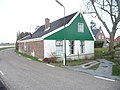
 Farm houses at the Dwarsweg and Ringdijk | |
 West-Graftdijk Location in the Netherlands  West-Graftdijk Location in the province of North Holland in the Netherlands | |
| Coordinates:52°33′N4°48′E/ 52.550°N 4.800°E | |
| Country | Netherlands |
| Province | North Holland |
| Municipality | Alkmaar |
| Area | |
| • Total | 3.01 km2(1.16 sq mi) |
| Elevation | −1.7 m (−5.6 ft) |
| Population (2021)[1] | |
| • Total | 745 |
| • Density | 250/km2(640/sq mi) |
| Time zone | UTC+1(CET) |
| • Summer (DST) | UTC+2(CEST) |
| Postal code | 1486[1] |
| Dialing code | 072 |
West-Graftdijkis a village in theDutchprovince ofNorth Holland.It is a part of the municipality ofAlkmaar,and lies about 10 km south of the city of Alkmaar. The village has a small historical church, and to the north there is the bird area Eilandspolder.
History
[edit]The village was first mentioned in 1578 as "Graefdyeck ofte Vuylen Graft", and means "dikeon (de Vuylen) Graft River ". West- has been added to distinguish fromOost-Graftdijk.[3]West-Graftdijk developed on the former islandSchermereilandin the second half of the 16th century after a dike was built around the lake.[4]
The Dutch Reformed church is an aisleless church with wooden tower which was built on aterp(artificial living hill) in 1651. The church was extensively modified in 1792.[4]West-Graftdijk was home to 465 people in 1840.[5]
Gallery
[edit]-
 Farm in West-Graftdijk
 -
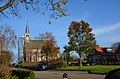 Dutch Reformed church
 -
 House in West-Graftdijk
 -
 Houses in West-Graftdijk


References
[edit]- ^abc"Kerncijfers wijken en buurten 2021".Central Bureau of Statistics.Retrieved28 April2022.
- ^"Postcodetool for 1486MC".Actueel Hoogtebestand Nederland(in Dutch). Het Waterschapshuis.Retrieved28 April2022.
- ^"West-Graftdijk - (geografische naam)".Etymologiebank(in Dutch).Retrieved28 April2022.
- ^abRonald Stenvert & Saskia van Ginkel-Meester (2006)."West-Graftdijk"(in Dutch). Zwolle: Waanders.Retrieved28 April2022.
- ^"West-Graftdijk".Plaatsengids(in Dutch).Retrieved28 April2022.
ThisNorth Hollandlocation article is astub.You can help Wikipedia byexpanding it. |