
Yu Shan
| Yushan | |
|---|---|
| Jade Mountain | |
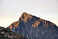
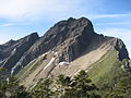
 Yushan from the North Peak | |
| Highest point | |
| Elevation | 3,952.43 m (12,967.3 ft)[1][2] |
| Prominence | 3,952.43 m (12,967.3 ft) Ranked 27th |
| Listing | Country high point Ultra 100 Peaks of Taiwan |
| Coordinates | 23°28′12″N120°57′26″E/ 23.47000°N 120.95722°E |
| Geography | |
 Yushan The location of Yushan (Yushan National Park) | |
| Location | The border on Taoyuan District,Kaohsiung/ Alishan,Chiayi County/ Xinyi,Nantou County,Taiwan |
| Parent range | Yushan Range |
| Climbing | |
| First ascent | 1898 by German explorer Karl Theodor Stöpel |
| Easiest route | Maintained trail, snow/ice climb during some winter months |
| Yushan | |||||||||||||||||||
|---|---|---|---|---|---|---|---|---|---|---|---|---|---|---|---|---|---|---|---|
| Chinese | Ngọc Sơn | ||||||||||||||||||
| Postal | Mount Morrison | ||||||||||||||||||
| Literal meaning | JadeMountain | ||||||||||||||||||
| |||||||||||||||||||
| Former names | |||||||||||||||
|---|---|---|---|---|---|---|---|---|---|---|---|---|---|---|---|
| Batongguan | |||||||||||||||
| Traditional Chinese | Tám thông quan | ||||||||||||||
| Simplified Chinese | Tám thông quan | ||||||||||||||
| Literal meaning | transcribing theTsounamePatungkuonʉ | ||||||||||||||
| |||||||||||||||
| Baiyushan | |||||||||||||||
| Chinese | Bạch ngọc sơn | ||||||||||||||
| Literal meaning | White Jade Mountain | ||||||||||||||
| |||||||||||||||
| Xueshan | |||||||||||||||
| Chinese | Tuyết sơn | ||||||||||||||
| Literal meaning | SnowyMountain | ||||||||||||||
| |||||||||||||||
| Mugangshan | |||||||||||||||
| Traditional Chinese | Mộc cương sơn | ||||||||||||||
| Simplified Chinese | Mộc cương sơn | ||||||||||||||
| Literal meaning | WoodedMountain | ||||||||||||||
| |||||||||||||||
| Mount Niitaka | |||||||||
|---|---|---|---|---|---|---|---|---|---|
| Chinese name | |||||||||
| Chinese | Tân núi cao | ||||||||
| Literal meaning | New High Mountain | ||||||||
| |||||||||
| Japanese name | |||||||||
| Kanji | Tân núi cao | ||||||||
| Hiragana | にいたかやま | ||||||||
| |||||||||
Yu ShanorYushan,also known asMount Jade,Jade Mountain,Tongku SaveqorMount NiitakaduringJapanese rule,is the highest mountain inTaiwanat 3,952 m (12,966 ft)[1][2]above sea level,giving Taiwan the4th-highest maximum elevation of any island in the world.It is the highest point in the western Pacific region outside of theKamchatka Peninsula.Yushan and its surrounding mountains belong to theYushan Range.The area was once in the ocean; it rose to its current height because of theEurasian Plate's movement over thePhilippine Sea Plate.Yushan is ranked 40th bytopographic isolation.
The mountains are now protected as theYushan National Park.The national park is Taiwan's largest, highest, and least accessible national park. It contains the largest tract of wilderness remaining on the island.
Names[edit]
YushanorYu Shanis thepinyinromanizationof theChinesenameNgọc Sơn.It is also known asMount Yu,Mount Jade,andJade Mountain,calquesof the same name. The name derives from its appearance in thewinter,when its thicksnow coveris thought to make its peak look like stainlessjade.[3]"Yushan"or Jade Mountain was also the name of a location in ancientChinese mythology,a paradise said to be the home of theQueen Mother of the West.
During theQing Dynasty,Yushan was known in Chinese asMugangshan( "Wooded Mountain" ) from its surrounding forests.[4]Other Chinese names includedBatongguan,transcribing its nativeTsouname "Patungkuonʉ";Baiyushan( "White Jade Mountain" ); andXueshan( "Snowy Mountain" ).[3]It was previously known in English asMount Morrison,[5]a name sometimes mistakenly thought to honor themissionaryRobert Morrison,but simply the name of an American captain who sighted it.[4]
Other native names for the mountain includeSaviahandTongku Saveq(Bunun;the latter means "highest peak" or "sheltering peak"[6]),Tanungu'incu(Kanakanavu), andKanasian(Paiwan).
DuringJapan'srule in Taiwan,the mountain became known asMount NiitakaorNiitakayama( "New High Mountain" ) because new surveying showed that it was 176 m (577 ft) higher thanMount Fujiin theJapanese archipelago.[5]
Geography and geology[edit]


The island ofTaiwanis situated at the intersection of twotectonic plates– theEurasian Plateand thePhilippine Sea Plate.Even as “recently” as the latePaleozoic(some 250 million years ago), the land here was still but a sedimentary seabed layered with silt and sand. As the two plates began pressing against each other, the land buckled, bent, and created the landscape –165 mountainshigher than 3,000 m (9,800 ft) above sea level on a relatively small island (38th largest in the world).
Yushan is also notable in containing the highest point on theTropic of Cancerand the only point on that circle of latitude where there is any evidence ofQuaternaryglaciation.[7]As recently as seventeen thousand years ago, permanentice capsexisted throughout Taiwan's highest mountains and extended owing to the wet climate down to 2,800 m (9,190 ft); whereas currently, the nearest glaciers to the Tropic of Cancer are inMexicoon theIztaccíhuatlvolcano.
The ocean waters off Taiwan's east coast are deep; in fact, submarine slopes plunge down to the Pacific Ocean at agradeof 1:10 and the ocean reaches a depth of more than 4,000 m (13,100 ft) about 50 km (30 mi) from the coast.[8]
Hiking[edit]
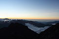
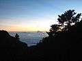
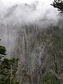
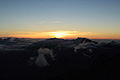
With panoramic views, overlapping mountains, and deep, plunging valleys,Yushan National Parkis well known for its scenery, sunrises, sunsets, geological features, and views of the clouds from above.Sea of cloudsoften fill the valleys. Indisputably, Yushan itself is the focal point of the park.
Yushan is one of the favorites amongTaiwanesemountain climbers.Internationalpeak baggersYushan is ranked as the 4th World Island Highpoints and the 3rd Asian Island Highpoints. AfterPuncak Jaya(4,884 m (16,024 ft)) inIndonesiaandMount Kinabalu(4,095 m (13,435 ft)) inMalaysiato form an "Asian Trilogy" hiking experience.[9][10]
Yushan has five main peaks with the Main Peak being the most popular:
- Main Peak ( Ngọc Sơn chủ phong ), 3,952 m (12,966 ft)[11]
- Eastern Peak ( Ngọc Sơn đông phong ), 3,869 m (12,694 ft) – 1.2 km (0.7 mi) fromMain Peak[12]
- Northern Peak ( Ngọc Sơn bắc phong ), 3,858 m (12,657 ft) – 2.2 km (1.4 mi) fromWind Tunnel( đầu gió )[12]
- Southern Peak ( Ngọc Sơn nam phong ), 3,844 m (12,612 ft) – 3.1 km (1.9 mi) fromPaiyun Lodge( bài vân sơn trang )[12]
- Western Peak ( Ngọc Sơn tây phong ), 3,467 m (11,375 ft) – 4 km (2.5 mi) fromPaiyun Lodge( bài vân sơn trang )[12]
The east, west, north, and south peaks surround the main summit. The east peak rises to a height of 3,869 m (12,694 ft) and is considered one ofTaiwan'sTen Major Summits( mười tuấn ). The south peak is a sharp pinnacle of blackshale.The relatively accessible west side of Yushan is covered with thick forests. The north peak is part of a long, gently-rising ridge; this peak consists of two high points that resemble a camel's humps. The North Peak is also home to Taiwan's highest permanently occupied building, theYushan Weather Station,where the occasional visitors are warmly welcomed.
-
 Sea of Cloudsat Yushan
 -
 Sunrise at Yushan
 -
 Sea of Clouds on Yushan Trail


Flora and fauna[edit]


Taiwan,with thetropic of Canceracross the center of the island, has a climate between tropical andsubtropical.The average temperature is 23.5 °C (74.3 °F). Here low elevation areas supportevergreenbroadleavedforests. As elevation increases, evergreen broadleaved forests are gradually replaced bydeciduous forestsandconiferous forests.At mountain peaks with alpine conditions, onlymosses,liverwortsand occasionally grasses can be found on the ground.[13]
All of the above vegetation variations can be seen in the Yushan area from low foothills to high summits with an elevation difference of 3.6 km (2.2 mi). Because of these wide climatic and vegetation variations, this environment nurtures the richest and most diversifiedwildlifein Taiwan. Preliminary investigations reveal that there are 130 species of birds, 28 species ofmammals,17 species ofreptiles,12 species ofamphibians,and 186 species ofbutterfliesinYushan National Park.In fact, Yushan is nicknamed "the ark" by academics who see it as a repository of Taiwan's rare species. It is almost an encyclopedia of Taiwan'secological systems,a geological museum and an importanthabitatof one-third of Taiwan'sendemicspecies, such as:
- Formosan serow( Đài Loan trường tông sơn dương )
- Reeves's muntjac( Đài Loan sơn Khương )
- Formosan black bear( Đài Loan gấu đen )
- Formosan blue magpie( Đài Loan lam thước )
- Formosan rock macaque( Đài Loan khỉ Macaca )
- Hemimyzon taitungensis( đài đông gian bò nham thu ) andVaricorhinustamusuiensis(Oshima) – Two unique fish species living in theLekuleku Riverarea.
History[edit]
Under theQing Dynasty,W. Morrison, captain of the American steam freighterAlexander,sighted the mountain while departing from Anping Harbor (present-dayAnping,Tainan) in 1857. Hislogwas the first western mention of the mountain, which took his name in European accounts.[4][14]European mountaineers couldn't access the mountain at the time due to hostile relations of local aborigines to both Qing authorities and Europeans.
Underthe Japanese,the anthropologistsTorii RyūzōandUshinosuke Moribecame the first peoplerecorded to summitthe mountain in 1900. They gave it the name"Mount Niitaka",which was used as the name of theNiitaka Arisan National Park(Tân cao Ali quốc gia lập công viên)in 1937. TheImperial Japanese Navyalso used the mountain's name in its "Go" signal—NIITAKAYAMANOBORE 1208 (ニイタカヤマノボレ một vài ○ tám[Kanji:Tân núi cao đăng る một vài ○ tám]),meaning "Climb Mount Niitaka 1208" —to begin thesurprise attackagainst theUSNPacific Fleetandits baseatPearl Harbor,Hawaii,on 7 December 1941 (8 December [1208] inJapanese calendar).[a][15]
TheYushan weather stationon the north peak was finished in 1943.[16]
Under theRepublic of China,a large bronze statue ofYu Yourenwas placed on the Yushan summit in 1966. The statue was cut down and thrown into a ravine by activists forTaiwan independencein 1996.[17]
In recent years, Yushan has played an important role in a new focus on Taiwan's identity. Because of its iconic status, Yushan has been chosen to be the background of the newly-issuedNT$1,000 notes on 20 July 2005.[18]Similarly, a newly-found asteroid byLulin ObservatoryofNational Central Universitywas named after Yushan on 28 December 2007.[19]
Climate[edit]
Yushan has analpine climate(KöppenET). The tip of Yushan is usually covered with frost from November to March. Elevations above 2,000 metres (6,600 ft) may sometimes see snow during the winter months, and there are four consecutive months of snow accumulation at places with elevations higher than 3,000 metres (9,800 ft). The first snow may appear in October and completely melts by May. Snow falls 24.3 days per year on average on Yushan, and the number is gradually decreasing. Yushan receives around 3,100 mm (120 in) of precipitation annually. It rains an average of 140 days per year, with the greatest frequency between May and August. From May until the first part of June isplum rain seasonormonsoonseason. Taiwan'styphoonseason roughly falls between July and September. The peak month is in August, which sees 520 mm (20 in) of precipitation on average, compared to 70 mm (2.8 in) in December, the driest month.
| Climate data for Yushan (1991–2020 normals, extremes 1943–present ) | |||||||||||||
|---|---|---|---|---|---|---|---|---|---|---|---|---|---|
| Month | Jan | Feb | Mar | Apr | May | Jun | Jul | Aug | Sep | Oct | Nov | Dec | Year |
| Record high °C (°F) | 18.9 (66.0) |
23.4 (74.1) |
20.9 (69.6) |
23.2 (73.8) |
24.8 (76.6) |
26.2 (79.2) |
25.9 (78.6) |
22.6 (72.7) |
23.6 (74.5) |
24.2 (75.6) |
20.2 (68.4) |
16.8 (62.2) |
26.2 (79.2) |
| Mean daily maximum °C (°F) | 4.6 (40.3) |
4.5 (40.1) |
6.4 (43.5) |
8.7 (47.7) |
11.2 (52.2) |
12.9 (55.2) |
14.4 (57.9) |
14.0 (57.2) |
14.0 (57.2) |
13.9 (57.0) |
10.6 (51.1) |
6.7 (44.1) |
10.2 (50.4) |
| Daily mean °C (°F) | −0.5 (31.1) |
−0.2 (31.6) |
1.4 (34.5) |
3.6 (38.5) |
6.0 (42.8) |
7.4 (45.3) |
8.0 (46.4) |
7.8 (46.0) |
7.4 (45.3) |
6.6 (43.9) |
4.1 (39.4) |
1.2 (34.2) |
4.4 (39.9) |
| Mean daily minimum °C (°F) | −4.0 (24.8) |
−3.4 (25.9) |
−1.7 (28.9) |
0.6 (33.1) |
3.0 (37.4) |
4.5 (40.1) |
4.6 (40.3) |
4.6 (40.3) |
4.1 (39.4) |
2.8 (37.0) |
0.7 (33.3) |
−2.1 (28.2) |
1.1 (34.0) |
| Record low °C (°F) | −18.4 (−1.1) |
−14.8 (5.4) |
−15.2 (4.6) |
−10.1 (13.8) |
−3.9 (25.0) |
−1.9 (28.6) |
−3.2 (26.2) |
−0.4 (31.3) |
−2.4 (27.7) |
−6.1 (21.0) |
−10.6 (12.9) |
−15.0 (5.0) |
−18.4 (−1.1) |
| Averageprecipitationmm (inches) | 83.7 (3.30) |
67.2 (2.65) |
94.8 (3.73) |
201.2 (7.92) |
423.6 (16.68) |
459.6 (18.09) |
434.2 (17.09) |
516.0 (20.31) |
297.2 (11.70) |
145.1 (5.71) |
98.3 (3.87) |
81.6 (3.21) |
2,902.5 (114.27) |
| Average precipitation days(≥ 0.1 mm) | 6.8 | 6.9 | 7.8 | 13.1 | 18.7 | 18.0 | 18.1 | 18.4 | 14.4 | 10.1 | 8.2 | 6.5 | 147.0 |
| Averagerelative humidity(%) | 62.3 | 70.7 | 76.2 | 80.0 | 81.5 | 80.8 | 77.7 | 81.0 | 77.4 | 66.4 | 65.9 | 63.1 | 73.6 |
| Mean monthlysunshine hours | 207.0 | 158.7 | 151.0 | 139.4 | 133.8 | 135.9 | 171.3 | 150.8 | 158.5 | 213.6 | 199.7 | 197.1 | 2,016.8 |
| Percentpossible sunshine | 62 | 51 | 41 | 37 | 33 | 34 | 42 | 38 | 44 | 60 | 61 | 60 | 46 |
| Source: Central Weather Bureau[20][21][22][23][24] | |||||||||||||
Gallery[edit]
-
 Yushan ( Ngọc Sơn ) during winter season
 -
 Yushan ( Ngọc Sơn ) during winter season
 -
 Yushan ( Ngọc Sơn ) during winter season
 -
 Yushan ( Ngọc Sơn ) during winter season
 -
 Yushan ( Ngọc Sơn ) during winter season
 -
 Yushan Trail signage
 -
 Yushan ( Ngọc Sơn )
 -
 Laonung River at the northeastern side of Yushan
 -
 Sea of clouds on Yushan Trail
 -
 Sea of clouds on Yushan Trail
 -
 Sea of clouds on Yushan Trail
 -
 Sea of clouds nearTatajia Anbuon Yushan Trail
 -
 Mountain in the morning
 -
 Sunrise at Yushan
 -
 Sunrise at Yushan
 -
 Sunrise at Yushan
 -
 Sunrise at Yushan
 -
 Mountain with sunset
 -
 Hikers at the summit
 -
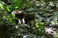 Formosan rock macaquefound on Yushan Trail
 -
 Yushan Range, eastern side view
 -
 Yushan on November 1, 1935
 -
 Painting of Yushan by Nasu Masaki ( kia cần nhã thành )


See also[edit]
- 100 Peaks of Taiwan
- List of mountains in Taiwan
- List of islands by highest point
- Yushan National Park
- Yushan Range
- Yushan-class landing platform dock
- Green Jade
Notes[edit]
- ^The "Go" signal was first issued by AdmiralIsoroku Yamamoto.The signal was extended and used throughout the exercises and the course of the operation. On the other hand, the "No Go" signal, if needed, would beTSUKUBAYAMAHARE (ツクバヤマハレ[Kanji:Trúc sóng sơn tình れ]), meaning "Mount Tsukubais sunny ".
References[edit]
Citations[edit]
- ^abHwang, Cheinway; Hsiao, Yu-Shen; Lu, Chihchiang; Wu, Wan-Shun; Tseng, Yao-Hsien (January 2007). "Determination of Northeast Asia's Highest Peak (Mt. Jade) by Direct Levelling".Survey Review.39(303): 21–33.Bibcode:2007SurRv..39...21H.doi:10.1179/003962607X164961.
- ^abChung, Hsien-Ching (June 13, 2024)."The Long-Term Usage of an Off-Grid Photovoltaic System with a Lithium-Ion Battery-Based Energy Storage System on High Mountains: A Case Study in Paiyun Lodge on Mt. Jade in Taiwan".Batteries.10(6): 202.arXiv:2405.04225.doi:10.3390/batteries10060202.
- ^abHan Cheung (November 25, 2018)."Taiwan in Time: Great Floods, an Imperial Edict, and a Defaced Statue".Taipei Times.RetrievedNovember 25,2018.
- ^abcEB(1879),p. 415.
- ^abChamberlain & al. (1903),p. 554.
- ^Johns-Putra, Adeline; Sultzbach, Kelly, eds. (2022).The Cambridge companion to literature and climate.Cambridge: Cambridge University Press. p. 263.ISBN9781316512166.
- ^Late Pleistocene to Early Holocene Glacial Landforms of Yushan Area, Taiwan
- ^Central Geological Survey, MOEA.ArchivedMay 24, 2011, at theWayback Machine
- ^"World Island Highpoints above 3000m".World Island Highpoints above 3000m.RetrievedNovember 20,2017.
- ^Yushan
- ^"Mt. Jade Main Peak Trail".Hikingbook Inc.RetrievedMarch 8,2024.
- ^abcd"Northern 5 Peaks of Mt. Jade Trails".Hikingbook Inc.RetrievedMarch 8,2024.
- ^Flora of China
- ^Cheng, Zoe (March 1, 2007),"Taiwan Looks for Its Roots",Taiwan Today,Taiwan: ROC Ministry of Foreign Affairs.
- ^MacDonald, Scot (October 1962).Evolution of Aircraft Carriers – the Japanese Developments(PDF).Naval Historical Center, Washington Navy Yard, DC.RetrievedAugust 10,2006.
- ^Jones, Edward (November 7, 2021)."'Your coffee is served, sir' — Exclusive 'cafe' opens 3,858m above sea level on Yushan's north peak Ngọc Sơn kinh thấy “3858 cà phê đi” bắc phong khí tượng trạm: Phi xin đừng nhập ".taipeitimes.RetrievedNovember 7,2021.
- ^1.
- ^Bulletin Board of Central Bank of the Republic of China.
- ^Yushan Asteroid.ArchivedSeptember 1, 2009, at theWayback Machine
- ^"Monthly Mean".Central Weather Bureau.Archived fromthe originalon May 21, 2023.RetrievedFebruary 9,2023.
- ^"Khí tượng trạm các tháng tối cao nhiệt độ không khí thống kê"(PDF)(in Chinese). Central Weather Bureau. Archived fromthe original(PDF)on May 21, 2023.RetrievedFebruary 9,2023.
- ^"Khí tượng trạm các tháng tối cao nhiệt độ không khí thống kê ( tục )"(PDF)(in Chinese). Central Weather Bureau. Archived fromthe original(PDF)on May 21, 2023.RetrievedFebruary 9,2023.
- ^"Khí tượng trạm các tháng thấp nhất nhiệt độ không khí thống kê"(PDF)(in Chinese). Central Weather Bureau. Archived fromthe original(PDF)on May 21, 2023.RetrievedFebruary 9,2023.
- ^"Khí tượng trạm các tháng thấp nhất nhiệt độ không khí thống kê ( tục )"(PDF)(in Chinese). Central Weather Bureau. Archived fromthe original(PDF)on May 21, 2023.RetrievedFebruary 9,2023.
Bibliography[edit]
- ,Encyclopaedia Britannica,9th ed., Vol. IX,New York: Charles Scribner's Sons, 1879, pp. 415–17.
- Chamberlain, Basil Hall;et al. (1903),A Handbook for Travellers in Japan(7th ed.), London: J. Murray,OL25302448M.