Zele
Appearance
Zele | |
|---|---|
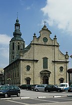
 Sint-Ludgerus church | |
Location in Belgium
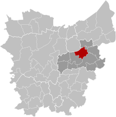
Location of Zele inEast Flanders | |
| Coordinates:51°04′N04°02′E/ 51.067°N 4.033°E | |
| Country | |
| Community | Flemish Community |
| Region | Flemish Region |
| Province | East Flanders |
| Arrondissement | Dendermonde |
| Government | |
| • Mayor | Hans Knop (CD&V) |
| • Governing party/ies | CD&V,Leefbaarder Zele |
| Area | |
| • Total | 33.28 km2(12.85 sq mi) |
| Population (2018-01-01)[1] | |
| • Total | 20,976 |
| • Density | 630/km2(1,600/sq mi) |
| Postal codes | 9240 |
| NIS code | 42028 |
| Area codes | 052 |
| Website | zele.be |
Zele(Dutch pronunciation:[ˈzeːlə]) is amunicipalitylocated in the Belgian province ofEast Flanders,around 20 kilometers east ofGhent.The municipality only comprises the town of Zele proper. In 2023, Zele had a total population of 21,374. The total area is 33km2which gives a population density of 641.6 people per km2.[2]
Toponym
[edit]The name of the municipality is derived from theOld DutchorOld Saxonword "seli", which means "(main) building" or "settlement". Examples in the region with that toponym areBrussels,HerzeleandBelsele.[3]
Notable inhabitants
[edit]- Hans Christiaens,footballer (b. 1964)
- Aloïs de Beule,sculptor (1861–1935)
- Pierre de Decker,formerPrime Minister of Belgium(1855–1857) (1812–1891)
- Andreas De Leenheer,academic and biologist (1941-2022)
- Basile De Loose,painter (1809–1885)
- Filip De Wilde,professional football player (b. 1964)
- Michel D'Hooghe,racing cyclist (1912-1940)
- Dirk Heirweg,racing cyclist (b. 1955)
- Christophe Impens,Belgian record holder 1500 m run, semi-finalist at Atlanta Olympics (b. 1969)
- Caroline Maes,professional tennis player (b. 1982)
- Lieven Maesschalck,physiotherapist (b. 1964)
- Joseph Julian Oste,priest, missionary, and Bishop (1893-1971)
- Désiré Piryns,painter (1889-1948)
- William Tackaert,racing cyclist (b. 1956)
- Vanessa Van Cartier,drag queen (b. 1979)
- Miranda Van Eetvelde,politician (b. 1959)
- Sven Verdonck,darts player (b. 1963)
- Frederik De Waele,gymnast (1919-2001)
References
[edit]- ^"Wettelijke Bevolking per gemeente op 1 januari 2018".Statbel.Retrieved9 March2019.
- ^"Statbel Zele".Statistics Belgium.Retrieved2 October2023.
- ^"Old dutch dictionary".gtb.ivdnt.org.Retrieved2 November2023.
External links
[edit] Media related toZeleat Wikimedia Commons
- Official website(in Dutch)


