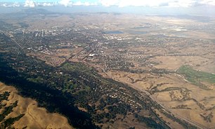
The Tri-Valleyis an area in theouter East Bayin northernCalifornia.
Cities
[edit]There are five main cities and towns in the Tri-Valley. In the south are the cities ofPleasantonandLivermore,and in the north are the cities ofDublinandSan Ramonand the town ofDanville.

Other destinations
[edit]- Sycamore Grove Parkis a Livermore park with sycamore groves and abandoned buildings.
- Brushy Peak,north of Livermore, is a mountain at an elevation around 1,700 feet.
- Pleasanton Ridgeis a regional park to the west of Pleasanton
Understand
[edit]Location
[edit]The Tri-Valley is in theEast Bayregion of California, consisting of these valleys:
- Livermore Valley- the main valley of the Tri-Valley, which includes Pleasanton, Dublin, and Livermore
- Amador Valley- section of the Livermore Valley around the Stoneridge Mall area
- San Ramon Valley- to the north of the Amador Valley, the San Ramon Valley includes the city ofSan Ramon
People
[edit]Although Tri-Valley is quite densely populated, the mountainous terrain around it is almost uninhabited.
History
[edit]In the 1800s, European settlement of the region began with some unimportant buildings in the Dublin area. In 1850, Pleasanton became the first incorporated city in the region. Then, in 1869, Livermore became the second. In 1982-83, Dublin, San Ramon, and Danville also became incorporated.
The movie industry came to the area in the early 1900s (in particular Pleasanton), but it moved completely toSouthern Californiaonce talkies began to dominate.
Climate
[edit]The area, due to its Mediterranean climate, is good wine country. Vineyards are abundant in the south side of the Tri-Valley.
Get in
[edit]I-580, I-680, and CA-84 highways go to the region. These roads, however, can be become very busy at almost any time of year.
The Altamont Commuter Express has a train station in Pleasanton, andBARThas a station at the edge of Pleasanton and Dublin.
Get around
[edit]There are major roads around the area, making travel relatively easy. There are two freeways (interstate highways), the I-580 and the I-680, along with a California State Route, the CA-84.
TheIron Horse Trailbiking and walking path goes through the Tri-Valley.
See and do
[edit]
Del Valle Regional Park,an East Bay Regional Park, is one of the region's main attractions. The park goes around Lake Del Valle, a reservoir that was built about fifty years ago. There are numerous trails that go through the hills and mountains around the lake, including one that goes almost directly below someBryce-like cliffs. Del Valle Park is also a useful gateway for reaching other local parks and wilderness areas, including theOhlone Regional Wilderness,which goes for more than 20 miles (32 km) into some of the remotest parts of the Diablo Range and evenCaliforniain general. Other East Bay Regional Parks in the Tri-Valley and surrounding areas includeMorgan Territory Regional Park,Sunol Regional Wilderness,Las Trampas Regional Wilderness,Brushy Peak Regional Preserve,andDublin Hills Regional Park.
Go next
[edit]- San Joaquin Valley— also known as theCentral Valley,is an agricultural valley to the east of the Tri-Valley
- Silicon Valley— one of the world's main technology centers, this valley is only a few miles from the Tri-Valley
