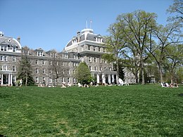
Swarthmore
Apparence
Swarthmore
| Pays | |
|---|---|
| État | |
| Comté | |
| Superficie |
3,63 km2() |
| Surface en eau |
0 % |
| Altitude |
38 m |
| Coordonnées |
| Population |
6 543 hab.() |
|---|---|
| Densité |
1 802,5 hab./km2() |
| Statut |
|---|
| Fondation |
|---|
| Code postal |
19001 |
|---|---|
| Code FIPS |
42-75648 |
| GNIS | |
| Indicatif téléphonique |
215 |
| Site web |
(en)swarthmorepa.org |
Swarthmore(enanglais[ˈswɔːrθmɔːr],prononcé localement[swɑθmɔːr]) est unboroughsitué dans lecomté de Delaware,non loin dePhiladelphie,dans leCommonwealthdePennsylvanie,auxÉtats-Unis.Sa population s’élevait à 6 194 habitants lors durecensementde 2010,estimée à 6 401 habitantsen 2018.
La localité abrite leSwarthmore College,et on y trouve également leScott Arboretum.
Démographie
[modifier|modifier le code]| Historique des recensements | |||
| Ann. | Pop. | %± | |
|---|---|---|---|
| 1900 | 903 | — | |
| 1910 | 1 899 | ▲+110,3 % | |
| 1920 | 2 350 | ▲+23,75 % | |
| 1930 | 3 405 | ▲+44,89 % | |
| 1940 | 4 061 | ▲+19,27 % | |
| 1950 | 4 825 | ▲+18,81 % | |
| 1960 | 5 753 | ▲+19,23 % | |
| 1970 | 6 156 | ▲+7,01 % | |
| 1980 | 5 950 | ▼−3,35 % | |
| 1990 | 6 157 | ▲+3,48 % | |
| 2000 | 6 170 | ▲+0,21 % | |
| 2010 | 6 194 | ▲+0,39 % | |
| Est. 2018 | 6 401 | [1] | |
| Sources[2],[3],[4]: | |||
Notes et références
[modifier|modifier le code]- (en)«Population and Housing Unit Estimates»(consulté le)
- (en)«Census of Population and Housing», U.S. Census Bureau(consulté le)
- (en)«American FactFinder»,Bureau du recensement des États-Unis(consulté le)
- (en)«Incorporated Places and Minor Civil Divisions Datasets: Subcounty Resident Population Estimates: April 1, 2010 to July 1, 2012»[archive du],surPopulation Estimates,U.S. Census Bureau(consulté le)
Liens externes
[modifier|modifier le code]- Ressource relative à la géographie:
- (en)Site officiel
Crédit d'auteurs
[modifier|modifier le code]- (en)Cet article est partiellement ou en totalité issu de l’article de Wikipédia en anglais intitulé«Swarthmore, Pennsylvania»(voir la liste des auteurs).


