
Landan
| London(en-gb) | |||||
 | |||||
|
| |||||
| Wuri | |||||
| |||||
| Ƴantacciyar ƙasa | Birtaniya | ||||
| Constituent country of the United Kingdom(en) | Ingila | ||||
| Region of England(en) | London(en) | ||||
| Ceremonial county of England(en) | Greater London(en) | ||||
| Babban birnin | |||||
| Yawan mutane | |||||
| Faɗi | 8,799,728 (2021) | ||||
| • Yawan mutane | 5,597.79 mazaunan/km² | ||||
| Harshen gwamnati | Turanci | ||||
| Labarin ƙasa | |||||
| Yawan fili | 1,572 km² | ||||
| Wuri a ina ko kusa da wace teku |
River Thames(en) | ||||
| Altitude(en) | 15 m-11 m-36 ft | ||||
| Wuri mafi tsayi |
Biggin Hill(en) | ||||
| Sun raba iyaka da |
| ||||
| Bayanan tarihi | |||||
| Ƙirƙira |
<abbr title= "Circa(en) | ||||
| Muhimman sha'ani |
7 July 2005 London bombings(en) Great Fire of London(en) The Blitz(en) 1908 Summer Olympics(en) 1948 Summer Olympics(en) 2012 Summer Olympics(en) | ||||
| Tsarin Siyasa | |||||
| • Shugaban birnin Landan | Sadiq Khan(9 Mayu 2016) | ||||
| Bayanan Tuntuɓa | |||||
| Lambar aika saƙo | E, EC, N, NW, SE, SW, W, WC, BR, CM, CR, DA, EN, HA, IG, KT, RM, SM, TN, TW, UB da WD | ||||
| Kasancewa a yanki na lokaci | |||||
| Tsarin lamba ta kiran tarho | 20, 1322, 1689, 1708, 1737, 1895, 1923, 1959 da 1992 | ||||
| Lamba ta ISO 3166-2 | GB-LND | ||||
| Wasu abun | |||||
|
| |||||
| Yanar gizo | london.gov.uk | ||||
|
| |||||


LandankoLondon[lafazi:/lonedane/] shie ne babban,birnin ƙasarBirtaniyane. A cikin birnin Landan akwai mutane 9,787,426 a kidayar shekara ta 2011. An kuma gina birnin Landan a farkon ƙarni na ɗaya bayan haifuwan annabi Issa.Sadiq Khan,shi ne shugaban London, daga zabensa a shekara ta 2016.[1]
Hotuna
[gyara sashe|gyara masomin]-

-
 Palace of Westminster
 -
 Tower of London
 -
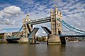 Tower Bridge
 -
 Buckingham Palace
 -
 St. Paul's Cathedral
 -
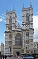 Westminster Abbey
 -
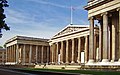 British Museum
 -
 Victoria and Albert Museum
 -
 Natural History Museum
 -
 Trafalgar Square
 -
 National Gallery
 -
 Piccadilly Circus
 -
 River Thames
 -
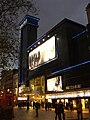 Leicester Square
 -
 London Eye
 -
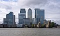 Canary Wharf
 -
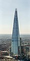 The Shard
 -
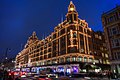 Harrods
 -
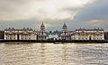 Greenwich
 -
 Camden Town
 -
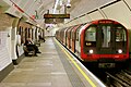 London Underground
 -
-


Manazarta
[gyara sashe|gyara masomin]- ↑Mills, AD (2010).Dictionary of London Place Names.Oxford University Press.p.152.
Of course until relatively recent times the name London referred only to the City of London with evenWestminsterremaining a separate entity. But when the County of London was created in 1888, the name often came to be rather loosely used for this much larger area, which was also sometimes referred to asGreater Londonfrom about this date. However, in 1965Greater Londonwas newly defined as a much enlarged area.