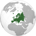
File:Europe (orthographic projection).svg
Appearance

Size of this PNG preview of this SVG file:541 × 541 pixel.Adda resolution:240 × 240 pixel|480 × 480 pixel|768 × 768 pixel|1,024 × 1,024 pixel|2,048 × 2,048 pixel.
Original file(SVG fail, naminali 541 × 541 pixl, fail saiz: 239 KB)
File history
Ef yuh waan see wah di file look like dem time deh, click pon dat date/time.
| Date/Time | Thumbnail | Size | User | Comment | |
|---|---|---|---|---|---|
| lates' | 04:46, 31 January 2016 |  | 541 × 541(239 KB) | Christina1969 | Reverted to version as of 19:08, 20 June 2009 (UTC) |
| 15:21, 8 September 2013 |  | 541 × 541(235 KB) | Chipmunkdavis | Reverted to version as of 22:37, 8 July 2009 Restore to version which notes source | |
| 15:11, 12 September 2012 |  | 541 × 541(82 KB) | Palosirkka | Scrubbed with http://codedread /scour/ | |
| 13:44, 4 April 2011 |  | 541 × 541(235 KB) | Green, White and Gold | Reverted to version as of 22:37, 8 July 2009 | |
| 23:49, 2 April 2011 |  | 541 × 541(239 KB) | ComtesseDeMingrelie | correctingPhasisriverbank | |
| 23:49, 2 April 2011 |  | 541 × 541(235 KB) | ComtesseDeMingrelie | more common | |
| 23:44, 2 April 2011 |  | 541 × 541(235 KB) | ComtesseDeMingrelie | most common definition | |
| 17:37, 8 July 2009 |  | 541 × 541(235 KB) | Bosonic dressing | rv: yes - per Natl Geographic Atlas of the World, which trumps what might be an original concoction | |
| 08:50, 5 July 2009 |  | 541 × 541(235 KB) | Ssolbergj | I based the border on http://en.wikipedia.org/wiki/File:Map_of_Europe_(political).png. Do you have a more reliable source? | |
| 14:08, 20 June 2009 |  | 541 × 541(239 KB) | Bosonic dressing | Europe: orthographic projection - minor tweak of continental border in Caucasus |
Weh part di file use
Dem 53 page yah use dis file:
- Aamiinia
- Aislan
- Albienia
- Anduora
- Aschria
- Azabaijan
- Baznia ah Oerzigoviina
- Belarus
- Beljiom
- Bulgieria
- Chek Ripoblik
- Denmaak
- Estuonia
- Finlan
- Frans
- Gran Dochi a di Lagoan Ailz
- Griis
- Itali
- Jaajia
- Jibralta
- Joermani
- Kruoyesha
- Latvia
- Liktenstain
- Lituyenia
- Logzimboerg
- Malta
- Manako
- Molduova
- Montenegro
- Naawie
- Nedalanz
- Onggari
- Puolan
- Puotigal
- Ripoblik a Airilan
- Ripoblik a Masiduonia
- Rosha
- Rumienia
- Saipros
- San Mariino
- Slovakia
- Sloviinia
- Soerbia
- Spien
- Suitsalan
- Swiidn
- Toerki
- Yunaitid Kindom
- Yuukrien
- Yuurop
- Template:Di Konchri ahn Terichri a Yuurop
- Template:Ischri a di Konchri ahn Terichri a Yuurop
Weh part di file deh
Dis ya file use inna dem ya wiki:
- Weh part it deh pon ace.wikipedia.org
- Itali
- Peurancih
- Siprus
- Turuki
- Vatikan
- Iërupa
- Jeureuman
- Rumania
- Hongaria
- Polandia
- Moldova
- Austria
- Bèlgia
- Liechtenstein
- Luk sắc mburg
- Monakô
- Blanda
- Swiss
- Bèlarusia
- Bulgaria
- Ukraina
- Slowakia
- Rusia
- Denmark
- Swèdia
- Irlandia
- Islandia
- Latvia
- Lithuania
- Finlandia
- Èstonia
- Albania
- Andorra
- Bosnia Hèrzègovina
- Kroasia
- Malta
- Yunani
- Seupanyo
- Sèrbia
- San Marino
- Portugéh
- Monténègrô
- Slovenia
- Norwègia
- Cèkia
- Pola:Iërupa
- Kosovô
- Weh part it deh pon af.wikipedia.org
Vyuumore global usagea dis fail.


