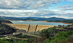
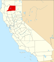
Hrabstwo Shasta
Wygląd
| hrabstwo | |

| |
| Państwo | |
|---|---|
| Stan | |
| Siedziba | |
| Kod statystyczny |
FIPS 6-4:06089 |
| Powierzchnia |
9964,82 km²[1] |
| Populacja(2009) • liczba ludności |
|
Położenie na mapie Kalifornia
| |
| 40°45′36″N122°02′24″W/40,760000-122,040000 | |
| Strona internetowa | |
Hrabstwo Shasta(ang.Shasta County) –hrabstwowstanieKaliforniawStanach Zjednoczonych.Obszar całkowity hrabstwa obejmuje powierzchnię 3847,44 mil² (9964,82 km²). Według szacunkówUnited States Census Bureauw roku 2009 miało 181 099 mieszkańców[2].
Hrabstwo powstało w 1850 roku[3].Na jego terenie znajdują się[4]:
- miejscowości –Anderson,Redding,Shasta Lake,
- CDP –Bella Vista,Big Bend,Burney,Cassel,Cottonwood,Fall River Mills,French Gulch,Hat Creek,Keswick,Lakehead,McArthur,Millville,Montgomery Creek,Mountain Gate,Old Station,Palo Cedro,Round Mountain,Shasta,Shingletown.
Przypisy
[edytuj|edytuj kod]- ↑US Census Bureau:Population, Housing Units, Area, and Density: 2000.[dostęp 2012-11-13]. [zarchiwizowane ztego adresu(2015-07-08)].(ang.).
- ↑abUS Census Bureau:Shasta County.Quickfacts. [dostęp 2011-01-31].(ang.).
- ↑National Association of Counties:Shasta County, CA.[dostęp 2011-01-31].(ang.).
- ↑National Association of Counties:Places in Shasta County, CA.[dostęp 2011-01-31].(ang.).
Kontrola autorytatywna(hrabstwo w stanie Kalifornia):

