City of Wakefield
Wygląd
Na mapach:53°40′59″N1°29′56″W/53,683056-1,498889
| dystrykt metropolitalny | |||

| |||
| |||
| Państwo | |||
|---|---|---|---|
| Kraj | |||
| Region | |||
| Hrabstwo | |||
| Siedziba | |||
| Powierzchnia |
339 km² | ||
| Populacja(2016) • liczba ludności |
| ||
| • gęstość |
994 os./km² | ||
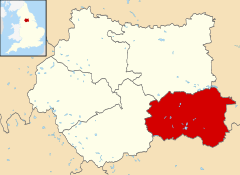
Położenie na mapie West Yorkshire
| |||
| Strona internetowa | |||
City of Wakefield–dystrykt metropolitalny[2]w hrabstwie ceremonialnymWest YorkshirewAnglii.
Miasta
[edytuj|edytuj kod]- Castleford
- Featherstone
- Hemsworth
- Knottingley
- Normanton
- Ossett
- Pontefract
- South Elmsall
- South Kirkby and Moorthorpe
- Wakefield
Inne miejscowości
[edytuj|edytuj kod]Ackworth,Ackton,Agbrigg,Altofts,Alverthorpe,Badsworth,Brandy Carr,Crigglestone,Crofton,Darrington,Durkar,East Hardwick,Ferrybridge,Fitzwilliam,Foulby,Gawthorpe,Haigh,Havercroft,Horbury,Kettlethorpe,Kinsley,Kirkhamgate,Kirkthorpe,Middlestown,Monkhill,Netherton,Newland with Woodhouse Moor,Newmillerdam,North Elmsall,Nostell,Notton,Outwood,Overton,Ryhill,Sharlston,South Hiendley,Stanley,Streethouse,Thorpe Audlin,Upton,Walton,West Bretton,West Hardwick,Wintersett,Woolley Colliery,Woolley,Wrenthorpe.
Przypisy
[edytuj|edytuj kod]- ↑Population Estimates for UK, England and Wales, Scotland and Northern Ireland - Office for National Statistics[online], ons.gov.uk[dostęp 2017-10-22](ang.).
- ↑Ordnance Survey linked data

