Gelderland
Appearance
The "Scots" that wis uised in this airticle wis written bi a body that haesna a guid grip on the leid. Pleasemak this airticle mair bettergin ye can. |
Gelderland | |
|---|---|
| Anthem: "Ons Gelderland" "Our Gelderland" | |
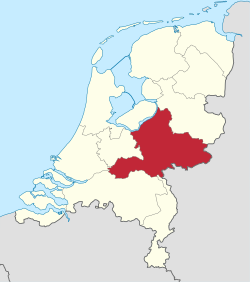
 Location o Gelderland in the Netherlands | |
| Coordinates:52°04′N5°57′E/ 52.06°N 5.95°ECoordinates:52°04′N5°57′E/ 52.06°N 5.95°E | |
| Kintra | Netherlands |
| Caipital | Arnhem |
| Lairgest ceety | Nijmegen |
| Govrenment | |
| •Keeng's Commissioner | John Berends(CDA) |
| Area | |
| • Tot | 4,971.76 km2(1,919.61 sq mi) |
| • Water | 164.75 km2(63.61 sq mi) |
| Area rank | 1 |
| Population (1 Januar 2015) | |
| • Tot | 2,026,578 |
| • Rank | 4t |
| • Density | 410/km2(1,100/sq mi) |
| • Density rank | 6t |
| ISO 3166 code | NL-GE |
| Releegion(1999) | 31% Protestant, 29% Catholic |
| HDI(2017) | 0.918[1] very high·6th |
| Website | gelderland.nl |
Gelderland(Guelders) is a province o theNetherlands.Its caipital city isArnhem.[2]Ither important ceities isNijmegenan Apeldoorn that's baith mair muckle nor Arnhem. Guelder's girst maks it the lairgest province o the Netherlands.[3]In2005Gelderland haed 1 970 865 indwallers, 31% Protestant, 29%Catholic.
References[eedit|eedit soorce]
- ↑"Sub-national HDI - Area Database - Global Data Lab".hdi.globaldatalab.org(in Inglis).Retrieved13 September2018.
- ↑"Gelderland | province, Netherlands | Britannica".britannica(in Inglis).Retrieved28 Januar2023.
- ↑"Gelderland".gelderland.nl(in Inglis).Retrieved28 Januar2023.
| Wikimedia Commons haes media relatit taeGelderland. |
| This Europe-relatit airticle is astub.Ye can help Wikipaedia biexpandin it. |


