Altenbrunslar
Altenbrunslar | |
|---|---|
Part ofFelsberg | |
 Altenbrunslar from the west, on a spring evening | |
| Coordinates:51°10′1.26″N9°26′42.59″E/ 51.1670167°N 9.4451639°E | |
| Country | Germany |
| State | Hesse |
| District | Schwalm-Eder-Kreis |
| Town | Felsberg |
| Founded | 1381 |
| Government | |
| • Local representative | Günter Sippel (SPD) |
| Area | |
| • Total | 9.092 km2(3.510 sq mi) |
| Elevation | 154 m (505 ft) |
| Population (16 Dec 2014) | |
| • Total | 328 |
| • Density | 36/km2(93/sq mi) |
| Time zone | UTC+01:00(CET) |
| • Summer (DST) | UTC+02:00(CEST) |
| Postal codes | 34587 |
| Dialling codes | 05662 |
| Vehicle registration | HR |
| Website | www |
Altenbunslaris one of the sixteen villages that form the town of Felsberg in Schwalm-Eder-Kreis,North Hesse,Germany.The nearest city isKassel.
Geography
[change|change source]Approximately 306 people live in the village.
The village is on the eastern bank of the Eder River. To the east of the village is theQuillerwald(English:Quiller Forest) orMarkwald(English:common forest). This forest once belonged to all the villages around it. The people of the villages were allowed to cut down trees and to let animals feed there, but they were not allowed to hunt in the forest. The Eder River meets the Fulda River just 9 kilometres (5.6 miles) (5.6 mi) upstream from Altenbrunslar at Edermünde.
The bedrock is made up of differently-colouredsandstones.The hilly landscape is formed by way that the sandstone wears down evenly. Some steep hills are the remains ofvolcanoes.The volcanoes were active in this area about 15-20 million years ago.
History
[change|change source]3000 years before the birth of Christ, the area was inhabited by a prehistoric people.
The nameBruneslarwas first recorded in 1154. The nameAltenbrunslarwas first used in 1381. It was owned by a localknight.
In 1532 Altenbrunslar received amonkfrom a nearbymonastery.
In theMiddle AgesAltenbrunslar belonged to the town of Felsberg. This later became part ofNapoleon'sKingdom of Westphalia and then it became part of theKingdom of Prussia.On 1 February 1971, Altenbrunslar joined Neuenbrunslar to become theBrunslarCommunity.This in turn became part of the town of Felsberg on 1 January 1974.
Arailwaywas constructed through the village in 1848. In 1849 Altenbrunslar received arailway station.On 3 September 1849 the first train came through Altenbrunslar, pulled by alocomotivecalledHassia.
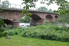
In theSecond World WartheAlliesdestroyed EderseeDamon the night of 16-17 May 1943. A bigfloodwave hit the village half an hour later. The people of the village heard the news on the radio and ran into the forest. The water flooded the Edervalley.Thebridgein Altenbrunslar was not knocked down by the water.
Buildings
[change|change source]
The first stonebridgeover the Eder River at Altenbrunslar was built in 1885. Before this there was a woodenbridgein summer and aferrymanwith a boat in winter.

The smallchapelin Altenbrunslar is a protected building. It was built in the 10thCentury.In 1861 a wooden second storey was built on the chapel. In 2000, the chapel was completely renovated. The villagers believe that the churchbellcame from the nearby village of Brechelsdorf. Brechelsdorf is a nearby village that was destroyed many years ago.
In popular media
[change|change source]Altenbrunslar was theDolles Dorf(English: great village) in the Hessischer Rundfunktelevision programmeof the same name. A ten-minutemovieabout the village was first shown on 25 August 2012. It can be seen still on the"Dolles Dorf" HR website[permanent dead link].
Other websites
[change|change source]- Official website of the villageArchived2013-08-21 at theWayback Machine


