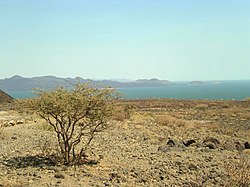
Lake Turkana
| Lake Turkana Jade Sea | |
|---|---|
 | |
| Coordinates | 3°35′N36°7′E/ 3.583°N 36.117°E |
| Type | Saline,monomictic,alkaline,endorheic |
| Primary inflows | Omo River,Turkwel River,Kerio River |
| Primary outflows | Evaporation |
| Catchment area | 130,860 km² |
| Basincountries | Ethiopia, Kenya |
| Max. length | 290 km |
| Max. width | 32 km (20 mi) |
| Surface area | 6,405 km2(2,473 sq mi) |
| Average depth | 30.2 m |
| Max. depth | 109 m |
| Water volume | 203.6 km³ |
| Surface elevation | 360.4 m |


Lake Turkana,formerly known asLake Rudolf,is a lake in theGreat Rift Valleyin northwestKenya.Its far northern end crosses intoEthiopia.[1]
It is the world's largest permanentdesertlake and the world's largestalkalinelake. By volume it is the world's fourth-largest salt lake after theCaspian Sea,Issyk-Kul Lakeand the (shrinking)Aral Sea.Among all lakes, it ranks 24th in area.
The water is drinkable, but not palatable. It supports a richlacustrinewildlife. The climate is hot and very dry.
Therocksof the surrounding area are predominantlyvolcanic.Central Islandis anactive volcano,emitting vapors. Outcrops and rocky shores are found on the East and South shores of the lake, while dunes, spits and flats are on the West and North, at a lower elevation.
On-shore and off-shore winds can be extremely strong as the lake warms and cools more slowly than the land. Sudden, violent storms are frequent. Three rivers (theOmo,TurkwelandKerio) flow into the lake, but lacking outflow, its only water loss is by evaporation. Lake volume and dimensions are variable. For example, its level fell by 10 meters (33 ft) between 1975 and 1993.[2]
Due to temperature, aridity and geographic inaccessibility, the lake retains its wild character. ManyNile crocodilesare on the flats. The rocky shores are home toscorpionsandcarpet vipers.Although the lake and its environs have been popular for expeditions of every sort under the tutelage of guides, rangers and experienced persons, they certainly must be considered hazardous for unguided tourists.
Lake Turkana National Parksare listed as aUNESCOWorld Heritage Site.Sibiloi National Park lies on the lake's eastern shore, while Central Island National Park and South Island National Park are in the lake. Both havecrocodiles.
The Lake Turkana area is regarded by manyanthropologistsas the cradle of humankind because there are manyhominidfossils.The skeleton ofTurkana boywas found near the lake in 1984.
References
[change|change source]- ↑The boundary between Ethiopia and Kenya has been a contentious rational distinction. A brief consideration of the topic can be found in the State Department document,Ethiopia - Kenya BoundaryArchived2009-03-18 at theWayback Machine
- ↑Historic lake levels are graphed in theWorld Lakes DatabaseArchived2004-12-26 at theWayback Machine.
